|
|
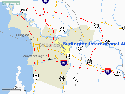
Burlington International Airport |
| Burlington International Airport |
 |
| IATA: BTV – ICAO: KBTV – FAA LID: BTV |
| Summary |
| Airport type |
Public |
| Owner |
City of Burlington |
| Serves |
Burlington, Vermont |
| Location |
South Burlington |
| Elevation AMSL |
335 ft / 102 m |
| Coordinates |
44°28′19″N 073°09′12″W / 44.47194°N 73.15333°W / 44.47194; -73.15333 |
| Website |
www.btv.aero |
| Runways |
| Direction |
Length |
Surface |
| ft |
m |
| 15/33 |
8,320 |
2,536 |
Asphalt |
| 1/19 |
3,611 |
1,101 |
Asphalt |
| Statistics (2008) |
| Aircraft operations |
90,271 |
| Based aircraft |
101 |
| Source: Federal Aviation Administration |
FAA airport diagram Burlington International Airport (IATA: BTV, ICAO: KBTV, FAA LID: BTV) is a joint civil-military public airport in South Burlington, Vermont. The airport is three miles (5 km) east of the central business district of Burlington, Vermont's largest city. BTV is owned by the City of Burlington. History
From 2000 to 2008, the airport experienced an increase in growth and service. Since 2000, $24 million in renovations and expansion has been invested at Burlington. In 2008, the airport authority completed a $15 million expansion project which added five gates — four with boarding bridges — and customer service areas, in addition to a 948-space parking garage and an elevated connected walkway.
For the 12-month period ending May 30, 2008, the airport had 90,271 aircraft operations, an average of 247 per day: 52% general aviation, 31% air taxi, 5% military and 12% scheduled commercial. There are 101 aircraft based at this airport: 50 single engine, 14 multi-engine, 8 jet aircraft, 1 helicopter and 28 military aircraft.
The airport set a local record in July 2008 when 79,154 passengers flew from Burlington, the first time the figure has crossed 70,000.
BTV enplaned over 759,000 people in 2008, a 7.3% increase from 2007.
Burlington International Airport serves the Burlington-South Burlington metropolitan area, which contained over 206,000 residents as of 2006 U.S. Census estimates. Due to the relatively small size of the market, airlines mostly fly regional airliners on their Burlington routes. A few airlines fly larger jets, such as the Airbus A320 family, to BTV; JetBlue Airways is one such carrier.
In 2008, Big Sky Airlines stopped flying the Boston route. Management has been searching for a replacement for this important route.
The airport has used natural resources such as marble and granite, and maple for interior decoration, intended to give the airport a "Vermont Feel". In 2009, the airport had fifteen gates serving seven airlines.
On February 3, 2010 it was announced that AirTran Airways would not be returning to Burlington. Service started in early 2009 on Boeing 717 aircraft operating 55 minute flights from Baltimore, but after only 6 months AirTran demoted BTV to seasonal service, operating only during the summer months. AirTran planned on resuming service in the spring of 2010, but due to various reasons not specified they did not. AirTran service lasted for 8 months in 2009. Southwest Airlines has indicated that it may pick up the route at some point on its Boeing 737 jets.
In 2010, it was announced that Plattsburgh International Airport will receive a federal subsidy to start operating a connection to Boston, thereby attracting the Canadian passengers that Burlington had been relying on.
In 2010, a city-owned cable provider was unable to pay the city of Burlington $17 million it owed. As a result, Moody's downrated the debt for the city. Moody's also downrated the credit rating for the airport, as well.
Airlines and destinations
BTV has flights to airline hubs in the East and Midwest, including New York, Philadelphia, Washington, Chicago, Cleveland, Detroit, and Orlando.
The following airlines offer scheduled flights at Burlington Airport:
| Airlines |
Destinations |
| Continental Connection operated by Colgan Air |
Newark |
| Continental Express operated by ExpressJet Airlines |
Cleveland, Newark |
| Delta Connection operated by Comair |
New York-JFK |
| Delta Connection operated by Freedom Airlines |
Detroit |
| Delta Connection operated by Pinnacle Airlines |
Detroit |
| JetBlue Airways |
New York-JFK, Orlando |
| United Express operated by Atlantic Southeast Airlines |
Washington-Dulles |
| United Express operated by ExpressJet Airlines |
Washington-Dulles |
| United Express operated by GoJet Airlines |
Chicago-O'Hare, Washington-Dulles |
| United Express operated by Mesa Airlines |
Chicago-O'Hare |
| United Express operated by Trans States Airlines |
Washington-Dulles |
| US Airways Express operated by Air Wisconsin |
Philadelphia, Washington-Reagan |
| US Airways Express operated by Piedmont Airlines |
New York-LaGuardia, Philadelphia |
| US Airways Express operated by Republic Airlines |
Philadelphia, Washington-Reagan |
Air cargo service
Both major commercial parcel carriers (UPS Airlines and FedEx Express) fly into BTV, providing service for much of northern Vermont. UPS uses Wiggins Airways to ferry packages between Burlington and larger cargo hubs.
| Cargo Airline |
Destination |
| FedEx Express |
Memphis, Portland (ME), Syracuse |
| UPS Airlines operated by Wiggins Airways |
Bangor, Dutchess County (NY), Manchester (NH), Rutland |
| Royal Air Freight |
Oakland County (MI), Newark |
Facilities
Burlington International Airport covers an area of 942 acres (381 ha) which contains two asphalt paved runways: 15/33 measuring 8,320 x 150 ft (2,536 x 46 m) and 1/19 measuring 3,611 x 75 ft (1,101 x 23 m).
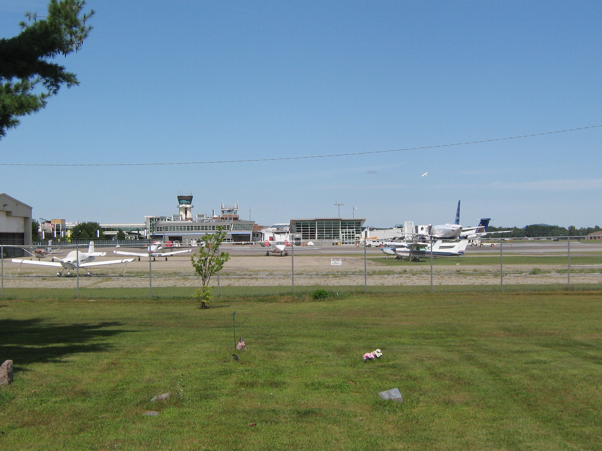
 | |
A general aviation ramp at BTV with the passenger terminal and tower in background |
In 2009, the Airport Authority sought $45 million for an expansion. If approved by Burlington city voters; it would provide 1,400 additional parking space to add onto the current 3 story, 2,100 spaces garage. It would hold 3,500 cars within 5 stories, with a completion date of late 2010 or early 2011.
As a Burlington-owned facility, it purchases its electricity from the city-owned utility.
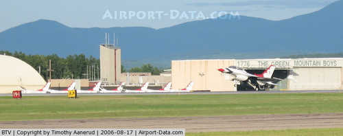
Military Facilities
Two military installations are based there. The first is Burlington Air National Guard Base, which includes the 158th Fighter Wing (158 FW), an Air Combat Command (ACC)-gained unit of the Vermont Air National Guard, flying the F-16C Fighting Falcon. The 158 FW consists of approximately 1000 Air National Guard personnel, both full-time Active Guard and Reserve (AGR) and Air Reserve Technician (ART) personnel and traditional part-time Air National Guardsmen.
The second installation is an Army Aviation Support Facility (AASF) of the Vermont Army National Guard, supporting the 1st Battalion, 103d Aviation Regiment and the 86th Medical Company (Air Ambulance).
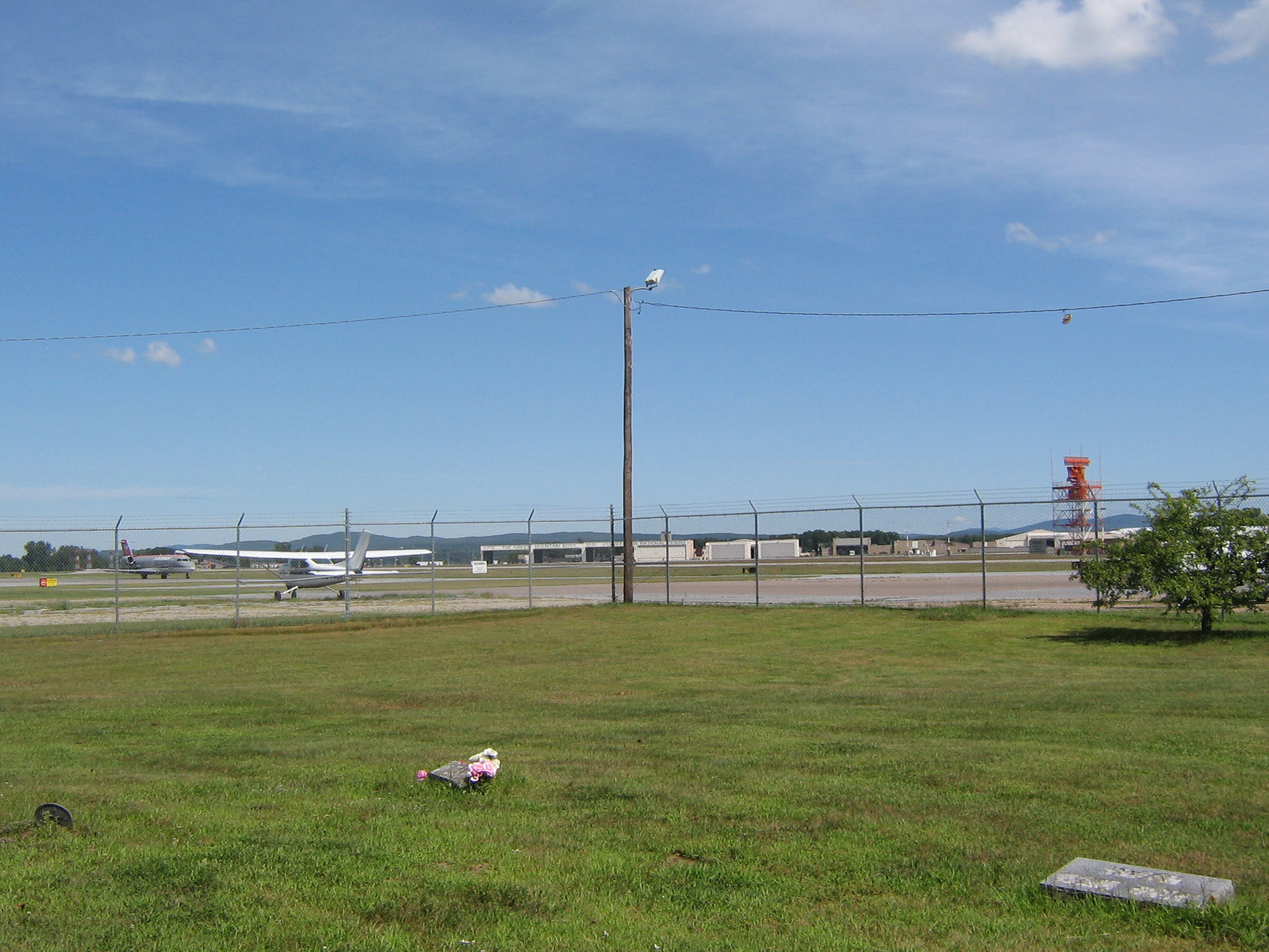
 | |
The ANG ramp now supporting the Green Mountain Boys squadron. |
Fixed base operator (FBO)
There are two fixed base operators at the airport. Each offers services such as de-icing, hangars and customs service for international traffic.
The above content comes from Wikipedia and is published under free licenses – click here to read more.
|
 |
(Click on the photo to enlarge) |
Location & QuickFacts
| FAA Information Effective: | 2008-09-25 |
| Airport Identifier: | BTV |
| Airport Status: | Operational |
| Longitude/Latitude: | 073-09-11.8000W/44-28-18.7000N
-73.153278/44.471861 (Estimated) |
| Elevation: | 335 ft / 102.11 m (Surveyed) |
| Land: | 942 acres |
| From nearest city: | 3 nautical miles E of Burlington, VT |
| Location: | Chittenden County, VT |
| Magnetic Variation: | 15W (2005) |
Owner & Manager
| Ownership: | Publicly owned |
| Owner: | City Of Burlington |
| Address: | City Hall
Burlington, VT 05401 |
| Phone number: | 802-658-9300 |
| Manager: | Brian Searles |
| Address: | 1200 Arpt Dr No 1
South Burlington, VT 05403 |
| Phone number: | 802-863-2874 |
Airport Operations and Facilities
| Airport Use: | Open to public |
| Wind indicator: | Yes |
| Segmented Circle: | No |
| Control Tower: | Yes |
| Lighting Schedule: | DUSK-DAWN
ACTVT PAPI RYS 01,15,19 & 33; MALSR RY 15 & MALSF RY 33 - CTAF. |
| Beacon Color: | Clear-Green (lighted land airport) |
| Landing fee charge: | Yes
FEE FOR ITINERANT ACFT GREATER THAN 3000 LBS. |
| Sectional chart: | Montreal |
| Region: | ANE - New England |
| Boundary ARTCC: | ZBW - Boston |
| Tie-in FSS: | BTV - Burlington |
| FSS on Airport: | No |
| FSS Toll Free: | 1-800-WX-BRIEF |
| NOTAMs Facility: | BTV (NOTAM-d service avaliable) |
| Certification type/date: | I B S 05/1973
ARFF AVBL SKED AIR CARRIER 0100-0500; ARFF UNAVBL UNSKED AIR CARRIER EXCP 24 HR PPR 0100-0500. |
| Federal Agreements: | NGY3P |
Airport Communications
| CTAF: | 118.300 |
| Unicom: | 122.950 |
Airport Services
| Fuel available: | 100LLA
NO SVC & NO ENTRY ACCESS 2200-0600 WITHOUT PPR 802-657-3100. |
| Airframe Repair: | MAJOR |
| Power Plant Repair: | MAJOR |
| Bottled Oxygen: | HIGH |
| Bulk Oxygen: | HIGH |
Runway Information
Runway 01/19
| Dimension: | 3611 x 75 ft / 1100.6 x 22.9 m |
| Surface: | ASPH, Good Condition |
| Weight Limit: | Single wheel: 30000 lbs.
Dual wheel: 40000 lbs.
Dual tandem wheel: 60000 lbs.
S OF RY 15/33 INTXN TO TWY C; SW 100 DTW 355; S OF TWY C INTXN TO S END OF RY; SW 30 DW 60. |
| Edge Lights: | Medium |
| |
Runway 01 |
Runway 19 |
| Longitude: | 073-09-03.6159W | 073-09-11.0393W |
| Latitude: | 44-27-49.7723N | 44-28-25.0303N |
| Elevation: | 334.00 ft | 329.00 ft |
| Alignment: | 127 | 127 |
| Traffic Pattern: | Left | Left |
| Markings: | Non-precision instrument, Good Condition | Basic, Good Condition |
| Crossing Height: | 40.00 ft | 42.00 ft |
| Displaced threshold: | 225.00 ft | 0.00 ft |
| VASI: | 4-light PAPI on right side | 2-light PAPI on right side |
| Visual Glide Angle: | 3.50° | 3.00° |
| Obstruction: | 19 ft tree, 575.0 ft from runway, 75 ft right of centerline, 20:1 slope to clear
18:1 TO DISPLACED THLD. | 50 ft trees, 1700.0 ft from runway, 250 ft right of centerline, 30:1 slope to clear |
| Decleard distances: | Take off run available 3611.00 ft
Take off distance available 3611.00 ft
Actual stop distance available 3611.00 ft
Landing distance available 3386.00 ft
| Take off run available 3611.00 ft
Take off distance available 3611.00 ft
Actual stop distance available 3386.00 ft
Landing distance available 3386.00 ft
|
|
Runway 15/33
| Dimension: | 8320 x 150 ft / 2535.9 x 45.7 m |
| Surface: | ASPH, Good Condition |
| Surface Treatment: | Saw-cut or plastic Grooved |
| Weight Limit: | Single wheel: 100000 lbs.
Dual wheel: 175000 lbs.
Dual tandem wheel: 355000 lbs.
S OF RY 15/33 INTXN TO TWY C; SW 100 DTW 355; S OF TWY C INTXN TO S END OF RY; SW 30 DW 60. |
| Edge Lights: | High |
| |
Runway 15 |
Runway 33 |
| Longitude: | 073-09-57.1761W | 073-08-30.3492W |
| Latitude: | 44-28-50.4358N | 44-27-56.7267N |
| Elevation: | 305.00 ft | 335.00 ft |
| Alignment: | 127 | 127 |
| ILS Type: | ILS/DME
| ILS/DME
|
| Traffic Pattern: | Left | Left |
| Markings: | Precision instrument, Good Condition | Precision instrument, Good Condition |
| Arresting: | MA1A | BAK12 |
| Crossing Height: | 51.00 ft | 53.00 ft |
| Displaced threshold: | 0.00 ft | 500.00 ft |
| VASI: | 4-light PAPI on right side | 4-light PAPI on right side |
| Visual Glide Angle: | 3.00° | 3.20° |
| RVR Equipment: | touchdown, rollout | touchdown, rollout |
| Approach lights: | MALSR | MALSF |
| Runway End Identifier: | | No |
| Obstruction: | 50 ft trees, 190.0 ft from runway, 225 ft left of centerline, 34:1 slope to clear | 35 ft trees, 1400.0 ft from runway, 550 ft left of centerline, 34:1 slope to clear
30:1 TO DSPLCD THLD. |
| Decleard distances: | Take off run available 7820.00 ft
Take off distance available 7820.00 ft
Actual stop distance available 7820.00 ft
Landing distance available 7820.00 ft
| Take off run available 8320.00 ft
Take off distance available 8320.00 ft
Actual stop distance available 8320.00 ft
Landing distance available 7820.00 ft
|
|
Radio Navigation Aids
| ID |
Type |
Name |
Ch |
Freq |
Var |
Dist |
| MPV | FAN MARKER | Brook | | | | 23.2 nm |
| VKN | NDB | Mount Mansfield | | 268.00 | 16W | 20.4 nm |
| JRV | NDB | Morrisville/stowe | | 375.00 | 16W | 25.1 nm |
| DYO | NDB | Smuto | | 221.00 | 15W | 46.8 nm |
| LLX | NDB | Lyndonville | | 353.00 | 16W | 48.2 nm |
| MPV | VOR/DME | Montpelier | 045X | 110.80 | 16W | 38.2 nm |
| SLK | VOR/DME | Saranac Lake | 029X | 109.20 | 14W | 45.4 nm |
| BTV | VORTAC | Burlington | 122X | 117.50 | 15W | 4.7 nm |
| PLB | VORTAC | Plattsburgh | 116X | 116.90 | 15W | 20.4 nm |
| YJN | VORTAC | St Jean | 105X | 115.80 | 16W | 47.7 nm |
| BTV | VOT | Burlington Intl | | 109.00 | | 0.3 nm |
Remarks
- CTN: GENERATING PLANT 2 NM FROM AER 15 PRODUCES STEAM WHICH MAY OBSCURE VSBY ON FAP.
- TWY L CLSD TO ACFT OVR 60000 LBS.
- ANG: PRIM TWY FOR MIL NON-FTR ACFT ARR/DEP IS E.
- ANG: NSTD TWY LGTS ON TWY 'E'.
- TWY D,E & F CLSD TO CIVILIAN OPS AND TWY N.
- A-GEAR: TYPE H/BAK-12A (B) AER 33 LCTD 1000 FT FM DSPLCD THLD.
- A-GEAR: TYPE H/BAK 12A(B) CABLE RAISED BY TWR ON PILOT REQ ONLY.
- CAUTION: PHASE II WILDLIFE ACTIVITY DURG MIGRATION, MAR-MAY & SEP-NOV.
- TWY A CLSD TO ACFT WITH WINGSPAN GREATER THAN 125 FT.
- MIL OPS WHEN TWR CLSD VFR ACFT STRONGLY ADVSD TO CTC ZBW 15 MIN PPR 120.35 2400-0530 DAILY.
- AIR CARRIER RAMP NOT AVAILABLE FOR PRIVATE AND/OR CHARTER AIRCRAFT.
- BIRDS & DEER ON AND INVOF ARPT.
- TWYS D E F & ANG RAMPS HAVE UNCONTROLLED VEHICLE & EQUIP TRAFFIC AND TWY N & ARNG RAMPS.
- TWY K CLSD TO ACFT OVER 68200 LBS.
- FIGHTER ACFT RESTRICTED TO TKOF WINDOW OF 0830-2230 MON-SAT; 1200-2230 SUN.
- EXISTED PRIOR TO 1959.
Images and information placed above are from
http://www.airport-data.com/airport/BTV/
We thank them for the data!
| General Info
|
| Country |
United States
|
| State |
VERMONT
|
| FAA ID |
BTV
|
| Latitude |
44-28-18.700N
|
| Longitude |
073-09-11.800W
|
| Elevation |
335 feet
|
| Near City |
BURLINGTON
|
We don't guarantee the information is fresh and accurate. The data may
be wrong or outdated.
For more up-to-date information please refer to other sources.
|
|