 |
|
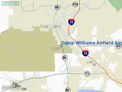
Camp Williams Airfield Airport |
Location & QuickFacts
| FAA Information Effective: | 2008-09-25 |
| Airport Identifier: | UT08 |
| Airport Status: | Operational |
| Longitude/Latitude: | 111-55-50.7660W/40-25-54.8180N
-111.930768/40.431894 (Estimated) |
| Elevation: | 4860 ft / 1481.33 m (Estimated) |
| Land: | 0 acres |
| From nearest city: | 0 nautical miles S of Camp Williams, UT |
| Location: | Utah County, UT |
| Magnetic Variation: | 15E (1985) |
Owner & Manager
| Ownership: | Publicly owned |
| Owner: | Utah National Guard |
| Address: | 12953 S State, Po Box 1776
Draper, UT 84020-9545 |
| Phone number: | 801-576-3309 |
| Manager: | Maj Curtis G Whiteford |
| Address: | 7563 S Airport Road
West Jordan, UT 84084 |
| Phone number: | 801-565-4409
OR 801-565-4414. |
Airport Operations and Facilities
| Airport Use: | Private |
| Wind indicator: | Yes |
| Segmented Circle: | No |
| Control Tower: | No |
| Landing fee charge: | No |
| Sectional chart: | Salt Lake City |
| Region: | ANM - Northwest Mountain |
| Boundary ARTCC: | ZLC - Salt Lake City |
| Tie-in FSS: | CDC - Cedar City |
| FSS on Airport: | No |
| FSS Toll Free: | 1-800-WX-BRIEF |
Airport Services
| Airframe Repair: | NONE |
| Power Plant Repair: | NONE |
Runway Information
Runway 18/36
| Dimension: | 4700 x 60 ft / 1432.6 x 18.3 m |
| Surface: | ASPH, |
| |
Runway 18 |
Runway 36 |
| Traffic Pattern: | Left | Right |
| Displaced threshold: | 300.00 ft | 0.00 ft |
|
Radio Navigation Aids
| ID |
Type |
Name |
Ch |
Freq |
Var |
Dist |
| TVY | NDB | Tooele | | 371.00 | 13E | 21.9 nm |
| DPG | NDB | Dugway | | 284.00 | 15E | 48.5 nm |
| HIF | TACAN | Hill | 049X | | 14E | 41.4 nm |
| MIJ | TACAN | Michael | 079X | | 15E | 47.7 nm |
| PVU | VOR/DME | Provo | 021X | 108.40 | 15E | 16.2 nm |
| FFU | VORTAC | Fairfield | 113X | 116.60 | 16E | 9.4 nm |
| TCH | VORTAC | Wasatch | 115X | 116.80 | 16E | 25.3 nm |
| OGD | VORTAC | Ogden | 104X | 115.70 | 14E | 48.2 nm |
| SLC | VOT | Salt Lake City | | 111.00 | | 11.7 nm |
Remarks
- MTNS & PLINE W.
- EXISTED PRIOR TO 1959.
Images and information placed above are from
http://www.airport-data.com/airport/UT08/
We thank them for the data!
| General Info
|
| Country |
United States
|
| State |
UTAH
|
| FAA ID |
UT08
|
| Latitude |
40-25-54.818N
|
| Longitude |
111-55-50.766W
|
| Elevation |
4860 feet
|
| Near City |
CAMP WILLIAMS
|
We don't guarantee the information is fresh and accurate. The data may
be wrong or outdated.
For more up-to-date information please refer to other sources.
|
|


