 |
|
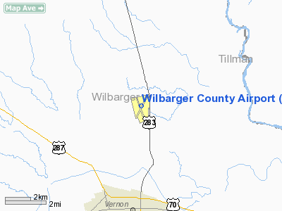
Location & QuickFacts
| FAA Information Effective: | 2008-09-25 |
| Airport Identifier: | F05 |
| Airport Status: | Operational |
| Longitude/Latitude: | 099-17-01.5000W/34-13-32.4000N
-99.283750/34.225667 (Estimated) |
| Elevation: | 1265 ft / 385.57 m (Surveyed) |
| Land: | 600 acres |
| From nearest city: | 4 nautical miles N of Vernon, TX |
| Location: | Wilbarger County, TX |
| Magnetic Variation: | 08E (1980) |
Owner & Manager
| Ownership: | Publicly owned |
| Owner: | Wilbarger County |
| Address: | County Courthouse
Vernon, TX 76384 |
| Phone number: | 940-553-2300 |
| Manager: | Wade Thomas |
| Address: | 12557 Apt Dr
Vernon, TX 76384 |
| Phone number: | 940-552-2182 |
Airport Operations and Facilities
| Airport Use: | Open to public |
| Wind indicator: | Yes |
| Segmented Circle: | Yes |
| Control Tower: | No |
| Lighting Schedule: | DUSK-DAWN
ACTVT VASI RY 20 - CTAF. |
| Beacon Color: | Clear-Green (lighted land airport) |
| Landing fee charge: | No |
| Sectional chart: | Dallas-ft Worth |
| Region: | ASW - Southwest |
| Boundary ARTCC: | ZFW - Fort Worth |
| Tie-in FSS: | FTW - Fort Worth |
| FSS on Airport: | No |
| FSS Phone: | 817-541-3474 |
| FSS Toll Free: | 1-800-WX-BRIEF |
| NOTAMs Facility: | F05 (NOTAM-d service avaliable) |
| Federal Agreements: | NGY3 |
Airport Communications
| CTAF: | 122.800 |
| Unicom: | 122.800 |
Airport Services
| Fuel available: | 100LLA
FOR FUEL AFT HRS CALL 940-839-6365. |
| Bottled Oxygen: | NONE |
| Bulk Oxygen: | NONE |
Runway Information
Runway 02/20
| Dimension: | 5099 x 100 ft / 1554.2 x 30.5 m |
| Surface: | ASPH, Good Condition |
| Weight Limit: | Single wheel: 30000 lbs.
Dual wheel: 40000 lbs.
Dual tandem wheel: 60000 lbs. |
| Edge Lights: | Medium |
| |
Runway 02 |
Runway 20 |
| Longitude: | 099-17-15.9995W | 099-16-43.9147W |
| Latitude: | 34-13-11.3757N | 34-13-54.1977N |
| Elevation: | 1264.00 ft | 1255.00 ft |
| Alignment: | 32 | 127 |
| Traffic Pattern: | Left | Left |
| Markings: | Non-precision instrument, Good Condition | Non-precision instrument, Good Condition |
| Crossing Height: | 0.00 ft | 25.00 ft |
| VASI: | | 4-box on left side |
| Visual Glide Angle: | 0.00° | 3.00° |
| Obstruction: | , 50:1 slope to clear | 10 ft road, 617.0 ft from runway, 317 ft left of centerline, 41:1 slope to clear |
|
Runway 16/34
| Dimension: | 4304 x 80 ft / 1311.9 x 24.4 m |
| Surface: | ASPH, Good Condition |
| Weight Limit: | Single wheel: 10000 lbs. |
| Edge Lights: | Medium |
| |
Runway 16 |
Runway 34 |
| Longitude: | 099-17-09.5406W | 099-16-56.9070W |
| Latitude: | 34-13-52.6692N | 34-13-11.4078N |
| Elevation: | 1258.00 ft | 1259.00 ft |
| Alignment: | 127 | 127 |
| Traffic Pattern: | Left | Left |
| Markings: | Non-precision instrument, Good Condition | Non-precision instrument, Good Condition |
|
Radio Navigation Aids
| ID |
Type |
Name |
Ch |
Freq |
Var |
Dist |
| VRT | NDB | Wilbarger | | 230.00 | 08E | 0.2 nm |
| SKB | NDB | Scotland | | 344.00 | 08E | 47.6 nm |
| PFL | NDB | Post | | 308.00 | 08E | 49.3 nm |
| SHP | TACAN | Sheppard | 045X | | 10E | 42.2 nm |
| LAW | VOR/DME | Lawton | 031X | 109.40 | 09E | 46.2 nm |
| LTS | VORTAC | Altus | 035X | 109.80 | 08E | 26.3 nm |
| SPS | VORTAC | Wichita Falls | 074X | 112.70 | 10E | 37.2 nm |
| HBR | VORTAC | Hobart | 055X | 111.80 | 10E | 40.0 nm |
Remarks
- MDT DUSTER OPNS DURG SPRING/SUMMER.
- PRE-DATES ACT.
Images and information placed above are from
http://www.airport-data.com/airport/F05/
We thank them for the data!
| General Info
|
| Country |
United States
|
| State |
TEXAS
|
| FAA ID |
F05
|
| Latitude |
34-13-32.405N
|
| Longitude |
099-17-01.500W
|
| Elevation |
1265 feet
|
| Near City |
VERNON
|
We don't guarantee the information is fresh and accurate. The data may
be wrong or outdated.
For more up-to-date information please refer to other sources.
|
|


