 |
|
Coordinates: 29°15′15″N 096°09′16″W / 29.25417°N 96.15444°W / 29.25417; -96.15444
| Wharton Regional Airport |
| IATA: WHT – ICAO: KARM – FAA LID: ARM |
| Summary |
| Airport type |
Public |
| Owner |
City of Wharton |
| Serves |
Wharton, Texas |
| Elevation AMSL |
100 ft / 30 m |
| Runways |
| Direction |
Length |
Surface |
| ft |
m |
| 14/32 |
5,004 |
1,525 |
Asphalt |
| Statistics (2005) |
| Aircraft operations |
11,800 |
| Source: Federal Aviation Administration |
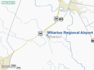
Wharton Regional Airport (IATA: WHT, ICAO: KARM, FAA LID: ARM) is a public airport located five miles (8 km) southwest of the central business district of Wharton, a city in Wharton County, Texas, United States. It is owned by the City of Wharton.
Although most U.S. airports use the same three-letter location identifier for the FAA and IATA, Wharton Regional is assigned ARM by the FAA and WHT by the IATA (which assigned ARM to Armidale Airport in Armidale, New South Wales, Australia). The airport's former FAA indentifier was 5R5.
Facilities and aircraft
Wharton Regional Airport covers an area of 124 acres (50 ha) which contains one asphalt paved runway (14/32) measuring 5,004 x 75 ft (1,525 x 23 m). For the 12-month period ending July 28, 2005, the airport had 11,800 aircraft operations, an average of 32 per day: 99% general aviation and 1% military.
The above content comes from Wikipedia and is published under free licenses – click here to read more.
Location & QuickFacts
| FAA Information Effective: | 2008-09-25 |
| Airport Identifier: | ARM |
| Airport Status: | Operational |
| Longitude/Latitude: | 096-09-15.8000W/29-15-15.4000N
-96.154389/29.254278 (Estimated) |
| Elevation: | 100 ft / 30.48 m (Surveyed) |
| Land: | 124 acres |
| From nearest city: | 5 nautical miles SW of Wharton, TX |
| Location: | Wharton County, TX |
| Magnetic Variation: | 06E (1985) |
Owner & Manager
| Ownership: | Publicly owned |
| Owner: | City Of Wharton |
| Address: | 120 E Caney
Wharton, TX 77488 |
| Phone number: | 409-532-2491
CITY HALL PHONE. |
| Manager: | David Allen |
| Address: | 120 E Caney
Wharton, TX 77488 |
| Phone number: | 979-532-3210
ARPT PHONE. |
Airport Operations and Facilities
| Airport Use: | Open to public |
| Wind indicator: | Yes |
| Segmented Circle: | Yes |
| Control Tower: | No |
| Lighting Schedule: | DUSK-DAWN
ACTVT MIRL RY 14/32 - CTAF. |
| Beacon Color: | Clear-Green (lighted land airport) |
| Landing fee charge: | No |
| Sectional chart: | Houston |
| Region: | ASW - Southwest |
| Boundary ARTCC: | ZHU - Houston |
| Tie-in FSS: | CXO - Montgomery County |
| FSS on Airport: | No |
| FSS Toll Free: | 1-800-WX-BRIEF
FOR FP FILING CALL CXO FSS 1-800-992-7433. |
| NOTAMs Facility: | ARM (NOTAM-d service avaliable) |
| Federal Agreements: | NGY |
Airport Communications
| CTAF: | 122.700 |
| Unicom: | 122.700 |
Airport Services
| Fuel available: | 100LLA
SELF SERVE FUEL AFT HRS WITH CREDIT CARD. |
| Airframe Repair: | MAJOR |
| Power Plant Repair: | MAJOR |
Runway Information
Runway 14/32
| Dimension: | 5004 x 75 ft / 1525.2 x 22.9 m |
| Surface: | ASPH, Good Condition |
| Weight Limit: | Single wheel: 22000 lbs. |
| Edge Lights: | Medium |
| |
Runway 14 |
Runway 32 |
| Longitude: | 096-09-29.6170W | 096-09-02.0650W |
| Latitude: | 29-15-36.9810N | 29-14-53.7330N |
| Elevation: | 100.00 ft | 97.00 ft |
| Alignment: | 127 | 127 |
| Traffic Pattern: | Left | Left |
| Markings: | Non-precision instrument, Good Condition | Non-precision instrument, Good Condition |
| Crossing Height: | 35.00 ft | 31.00 ft |
| VASI: | 4-light PAPI on left side | 4-light PAPI on left side |
| Visual Glide Angle: | 3.00° | 3.00° |
| Obstruction: | 31 ft pline, 1500.0 ft from runway, 41:1 slope to clear | , 50:1 slope to clear |
|
Radio Navigation Aids
| ID |
Type |
Name |
Ch |
Freq |
Var |
Dist |
| ARM | NDB | Wharton | | 245.00 | 06E | 0.1 nm |
| BYY | NDB | Bay City | | 344.00 | 06E | 23.0 nm |
| SGR | NDB | Hull | | 388.00 | 05E | 34.6 nm |
| SYG | NDB | Sandy Point | | 402.00 | 05E | 38.9 nm |
| LYD | NDB | Lakeside | | 249.00 | 05E | 42.0 nm |
| PKV | NDB | Port Lavaca | | 515.00 | 05E | 45.6 nm |
| EYQ | NDB | Weiser | | 286.00 | 06E | 48.9 nm |
| ELA | VOR/DME | Eagle Lake | 111X | 116.40 | 08E | 26.0 nm |
| VCT | VOR/DME | Victoria | 027X | 109.00 | 06E | 48.3 nm |
| PSX | VORTAC | Palacios | 120X | 117.30 | 08E | 30.5 nm |
| IDU | VORTAC | Industry | 039X | 110.20 | 08E | 47.3 nm |
Images and information placed above are from
http://www.airport-data.com/airport/ARM/
We thank them for the data!
| General Info
|
| Country |
United States
|
| State |
TEXAS
|
| FAA ID |
ARM
|
| Time |
UTC-6(-5DT)
|
| Latitude |
29.254278
29° 15' 15.40" N
|
| Longitude |
-96.154389
096° 09' 15.80" W
|
| Elevation |
100 feet
30 meters
|
| Type |
Civil
|
| Magnetic Variation |
004° E (01/06)
|
| Beacon |
Yes
|
| Operating Agency |
U.S.CIVIL AIRPORT WHEREIN PERMIT COVERS USE BY TRANSIT MILITARY AIRCRAFT
|
| Operating Hours |
SEE REMARKS FOR OPERATING HOURS OR COMMUNICATIONS FOR POSSIBLE HOURS
|
| Daylight Saving Time |
Second Sunday in March at 0200 to first Sunday in November at 0200 local time (Exception Arizona and that portion of Indiana in the Eastern Time Zone)
|
We don't guarantee the information is fresh and accurate. The data may
be wrong or outdated.
For more up-to-date information please refer to other sources.
|
|


