 |
|
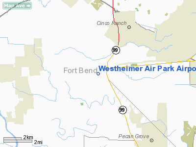
Westheimer Air Park Airport |
| Westheimer Air Park |
| IATA: none – ICAO: none – FAA LID: O07 |
| Summary |
| Airport type |
Public |
| Owner |
Reid Management Co. |
| Serves |
Houston, Texas |
| Location |
Fort Bend County, Texas |
| Elevation AMSL |
117 ft / 36 m |
| Coordinates |
29°41′41″N 095°47′41″W / 29.69472°N 95.79472°W / 29.69472; -95.79472 |
| Runways |
| Direction |
Length |
Surface |
| ft |
m |
| 11/29 |
2,500 |
762 |
Concrete |
| Statistics (2004) |
| Aircraft operations |
6,000 |
| Based aircraft |
28 |
| Source: Federal Aviation Administration |
Westheimer Air Park (FAA LID: O07) is a privately-owned, public-use airport in unincorporated Fort Bend County, Texas, United States. The airport is 20 nautical miles (37 km) west of the central business district of Houston. It is located along Farm to Market Road 1093 east of Fulshear.
Facilities and aircraft
Westheimer Air Park covers an area of 74 acres (30 ha) at an elevation of 117 feet (36 m) above mean sea level. It has one runway designated 11/29 with a 2,500 x 28 ft (762 x 9 m) concrete surface.
For the 12-month period ending September 2, 2004, the airport had 6,000 general aviation aircraft operations, an average of 16 per day. At that time there were 28 aircraft based at this airport: 96% single-engine and 4% multi-engine.
The above content comes from Wikipedia and is published under free licenses – click here to read more.
Location & QuickFacts
| FAA Information Effective: | 2008-09-25 |
| Airport Identifier: | O07 |
| Airport Status: | Operational |
| Longitude/Latitude: | 095-47-40.8210W/29-41-40.8370N
-95.794673/29.694677 (Estimated) |
| Elevation: | 117 ft / 35.66 m (Estimated) |
| Land: | 74 acres |
| From nearest city: | 20 nautical miles W of Houston, TX |
| Location: | Fort Bend County, TX |
| Magnetic Variation: | 06E (1985) |
Owner & Manager
| Ownership: | Privately owned |
| Owner: | Reid Management Co |
| Address: | 24215 Fm 1093
Richmond, TX 77469 |
| Phone number: | 281-468-6688 |
| Manager: | Bill Reid |
| Address: | 24215 Fm 1093
Richmond, TX 77469 |
| Phone number: | 281-341-9641 |
Airport Operations and Facilities
| Airport Use: | Open to public |
| Wind indicator: | Yes |
| Segmented Circle: | No |
| Control Tower: | No |
| Lighting Schedule: | RDO-CTL
ACTVT ROTG BCN - CTAF. |
| Beacon Color: | Clear-Green (lighted land airport) |
| Landing fee charge: | No |
| Sectional chart: | Houston |
| Region: | ASW - Southwest |
| Boundary ARTCC: | ZHU - Houston |
| Tie-in FSS: | CXO - Montgomery County |
| FSS on Airport: | No |
| FSS Toll Free: | 1-800-WX-BRIEF
FOR FP FILING CALL CXO FSS 1-800-833-5602. |
| NOTAMs Facility: | CXO (NOTAM-d service avaliable) |
Airport Communications
| CTAF: | 122.700 |
| Unicom: | 122.700 |
Airport Services
| Fuel available: | 100LL |
| Airframe Repair: | MINOR |
| Power Plant Repair: | MINOR |
Runway Information
Runway 11/29
| Dimension: | 2500 x 28 ft / 762.0 x 8.5 m |
| Surface: | CONC, Good Condition |
| Edge Lights: | Low |
| |
Runway 11 |
Runway 29 |
| Traffic Pattern: | Left | Left |
| Markings: | Nonstandard, Good Condition
NSTD NRS; NRS 30 FT TALL. NO CNTRLN STRIPE. | Nonstandard, Good Condition
NSTD NRS; NRS 30 FT TALL. NO CNTRLN STRIPE. |
| Obstruction: | 90 ft pline, 1500.0 ft from runway, 14:1 slope to clear
4 FT FENCE PARALLEL TO THLD 96 FT AWAY. +30 FT TREES 125 FT R OF CNTRLN. | 20 ft tree, 200.0 ft from runway, 15 ft left of centerline
4 FT FENCE AT THLD 75 FT L OF CNTRLN. |
|
Radio Navigation Aids
| ID |
Type |
Name |
Ch |
Freq |
Var |
Dist |
| SGR | NDB | Hull | | 388.00 | 05E | 8.2 nm |
| LYD | NDB | Lakeside | | 249.00 | 05E | 9.5 nm |
| EYQ | NDB | Weiser | | 286.00 | 06E | 16.5 nm |
| SYG | NDB | Sandy Point | | 402.00 | 05E | 20.6 nm |
| DWH | NDB | David Hooks | | 521.00 | 05E | 28.5 nm |
| ARM | NDB | Wharton | | 245.00 | 06E | 32.4 nm |
| BVP | NDB | Nixin | | 326.00 | 05E | 35.2 nm |
| JPA | NDB | Sanjac | | 347.00 | 05E | 37.9 nm |
| BYY | NDB | Bay City | | 344.00 | 06E | 43.5 nm |
| BNH | NDB | Brenham | | 362.00 | 06E | 43.8 nm |
| EFD | TACAN | Ellington | 031X | | 05E | 33.6 nm |
| HUB | VOR/DME | Hobby | 118X | 117.10 | 05E | 27.2 nm |
| ELA | VOR/DME | Eagle Lake | 111X | 116.40 | 08E | 27.4 nm |
| IAH | VORTAC | Humble | 113X | 116.60 | 05E | 28.2 nm |
| TNV | VORTAC | Navasota | 106X | 115.90 | 08E | 38.2 nm |
| IDU | VORTAC | Industry | 039X | 110.20 | 08E | 43.0 nm |
| HOU | VOT | Houston Wm P Hobby | | 108.40 | | 27.1 nm |
Remarks
- PRVDD A MINIMUM OF 20:1 SLOPE TO BOTH ENDS OF RWY IS MAINTAINED.
Images and information placed above are from
http://www.airport-data.com/airport/O07/
We thank them for the data!
| General Info
|
| Country |
United States
|
| State |
TEXAS
|
| FAA ID |
O07
|
| Latitude |
29-41-40.837N
|
| Longitude |
095-47-40.821W
|
| Elevation |
117 feet
|
| Near City |
HOUSTON
|
We don't guarantee the information is fresh and accurate. The data may
be wrong or outdated.
For more up-to-date information please refer to other sources.
|
|


