 |
|
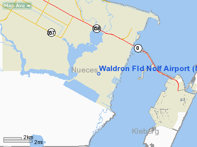
Location & QuickFacts
| FAA Information Effective: | 2008-09-25 |
| Airport Identifier: | NWL |
| Airport Status: | Operational |
| Longitude/Latitude: | 097-18-44.0000W/27-38-06.0000N
-97.312222/27.635000 (Estimated) |
| Elevation: | 25 ft / 7.62 m (Estimated) |
| Land: | 0 acres |
| From nearest city: | 6 nautical miles SS of Corpus Christi, TX |
| Location: | Nueces County, TX |
| Magnetic Variation: | () |
Owner & Manager
| Ownership: | Publicly owned |
| Owner: | U.s. Navy |
| Address: | 11001 D Street Suite 143
Corpus Christi, TX 78419 |
| Phone number: | 361-961-2332 |
| Manager: | Commander Officer, Nas |
| Address: | 11001 D Street Suite 143
Corpus Christi, TX 78419 |
| Phone number: | 361-961-2332 |
Airport Operations and Facilities
| Airport Use: | Private |
| Control Tower: | Yes |
| Lighting Schedule: | DUSK-DAWN |
| Sectional chart: | Brownsville |
| Region: | ASW - Southwest |
| Boundary ARTCC: | ZHU - Houston |
| Tie-in FSS: | SJT - San Angelo |
| FSS Toll Free: | 1-800-WX-BRIEF |
Runway Information
Runway 13/31
| Dimension: | 5000 x 200 ft / 1524.0 x 61.0 m |
| Surface: | ASPH, |
| Pavement Class: | 35 /F/B/W/T |
| Edge Lights: | Medium |
| |
Runway 13 |
Runway 31 |
| Traffic Pattern: | Left | Left |
| Displaced threshold: | 300.00 ft | 270.00 ft |
|
Runway 17/35
| Dimension: | 5000 x 200 ft / 1524.0 x 61.0 m |
| Surface: | ASPH, |
| Pavement Class: | 25 /F/B/W/T |
| Edge Lights: | Medium |
| |
Runway 17 |
Runway 35 |
| Traffic Pattern: | Left | Left |
| Displaced threshold: | 420.00 ft | 185.00 ft |
|
Radio Navigation Aids
| ID |
Type |
Name |
Ch |
Freq |
Var |
Dist |
| RKP | NDB | Rockport | | 391.00 | 06E | 30.8 nm |
| MNO | NDB | Mellon Ranch | | 375.00 | 06E | 39.2 nm |
| TKB | NDB | Kleberg County | | 347.00 | 06E | 41.2 nm |
| NQI | TACAN | Kingsville | 125X | | 09E | 27.5 nm |
| NOG | TACAN | Orange Grove | 063X | | 09E | 41.9 nm |
| ALI | VOR | Alice | | 114.50 | 06E | 38.3 nm |
| NGP | VORTAC | Truax | 087X | 114.00 | 06E | 3.2 nm |
| CRP | VORTAC | Corpus Christi | 102X | 115.50 | 09E | 17.6 nm |
Remarks
- RSTD: AVBL FOR NAVY TRNG ONLY.
- RSTD: NO FAC.
- RWY LGTS: RWYS 13 & 31 - OLS.
- RWY LGTS: RWYS 17 & 35 - OLS.
- CAUTION: IF EQUIPPED ALL ACFT SHALL UTILIZE UHF ATC FREQUENCIES UNLESS ASSIGNED VHF.
Images and information placed above are from
http://www.airport-data.com/airport/NWL/
We thank them for the data!
| General Info
|
| Country |
United States
|
| State |
TEXAS
|
| FAA ID |
NWL
|
| Time |
UTC-6(-5DT)
|
| Latitude |
27.635000
27° 38' 06.00" N
|
| Longitude |
-97.312225
097° 18' 44.01" W
|
| Elevation |
25 feet
8 meters
|
| Type |
Military
|
| Magnetic Variation |
005° E (01/06)
|
| Operating Agency |
US Navy
|
| Near City |
Corpus Christi
|
| Operating Hours |
SEE REMARKS FOR OPERATING HOURS OR COMMUNICATIONS FOR POSSIBLE HOURS
|
| Daylight Saving Time |
Second Sunday in March at 0200 to first Sunday in November at 0200 local time (Exception Arizona and that portion of Indiana in the Eastern Time Zone)
|
We don't guarantee the information is fresh and accurate. The data may
be wrong or outdated.
For more up-to-date information please refer to other sources.
|
|


