|
|
- For the radio stations in Andrews, Texas, see KACT (AM) and KACT-FM.
Coordinates: 31°36′41″N 097°13′50″W / 31.61139°N 97.23056°W / 31.61139; -97.23056
| Waco Regional Airport |
 |
| IATA: ACT – ICAO: KACT – FAA LID: ACT |
| Summary |
| Airport type |
Public |
| Owner |
City of Waco |
| Serves |
Waco, Texas |
| Elevation AMSL |
516 ft / 157 m |
| Website |
waco-texas.com/airport/... |
| Runways |
| Direction |
Length |
Surface |
| ft |
m |
| 1/19 |
6,596 |
2,010 |
Asphalt |
| 14/32 |
5,896 |
1,797 |
Asphalt |
| Statistics (2006) |
| Aircraft operations |
36,011 |
| Based aircraft |
100 |
| Source: Federal Aviation Administration |
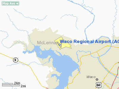
Waco Regional Airport (IATA: ACT, ICAO: KACT, FAA LID: ACT) is a public airport located five miles (8 km) northwest of the central business district of Waco, a city in McLennan County, Texas, United States. It is owned by the City of Waco.
The airport is a 20-25 minute drive by street to Downtown Waco and the Baylor University Campus. Facilities and aircraft
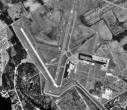
Waco Regional Airport covers an area of 1,369 acres (554 ha) which contains two asphalt paved runways: 1/19 measuring 6,596 x 150 ft (2,010 x 46 m) and 14/32 measuring 5,896 x 150 ft (1,797 x 46 m).
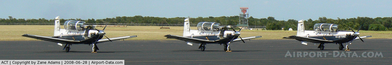
For the 12-month period ending December 31, 2006, the airport had 36,011 aircraft operations, an average of 98 per day: 65% general aviation, 27% air taxi, 8% military and 1% scheduled commercial. There are 100 aircraft based at this airport: 53% single-engine, 38% multi-engine, 6% jet and 3% helicopter.
The airport is currently planning for an expansion which would create three jetways, along with a larger lobby area and holding room. There is no wireless access at the airport; however, it is planned in the expansion.
Airlines and destinations
| Airlines |
Destinations |
| American Eagle |
Dallas/Fort Worth |
| Continental Connection operated by Colgan Air |
Houston-Intercontinental |
History
The airport was built by the United States Army Air Forces as a pilot training airfield, and was activated on 2 July 1942. It was initially named China Springs Army Air Field and was also known as Waco Army Air Field No. 2 before being renamed Blackland Army Airfield after the local black soil.
It was first a glider training school and in October 1942 Blackland was assigned to the AAF Gulf Coast Training Center, with the Army Air Force Pilot School (Advanced Twin-Engine) activated (phase 3 pilot training). The school's mission was to train cadets to fly transports and bombers. Pilot wings were awarded upon graduation and were sent on to group combat training by First, Second, Third or Fourth Air Force. Graduates were usually graded as Flight Officers (Warrant Officers); cadets who graduated at the top of their class were graded as Second Lieutenants.
The school used a number of trainers, including the AT-8, AT-9, AT-10, and B-25. On 8 January 1943, the War Department constituted and activated the 33d Flying Training Wing (Advanced Twin-Engine) at Blackland and assigned it to the AAF Central Flying Training Command.
Flying training at the airfield ended on 4 February 1945 and it became a sub-base of Waco Army Airfield. The field became inactive on October 31, 1945. By 1950 the facility was disposed of by the War Assets Administration (WAA) and deeded to the local government, being operated as Waco Municipal Airport. Some buildings were used as a public housing project.
The above content comes from Wikipedia and is published under free licenses – click here to read more.
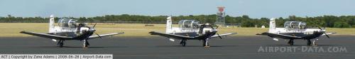 |
(Click on the photo to enlarge) |
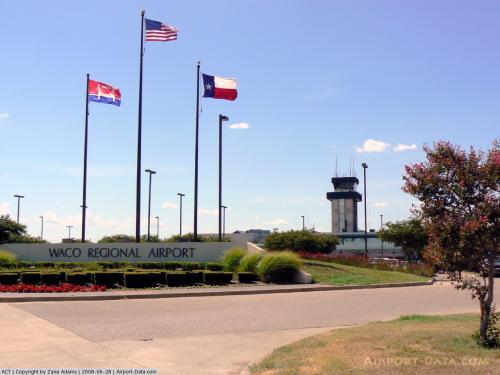 |
(Click on the photo to enlarge) |
 |
(Click on the photo to enlarge) |
Location & QuickFacts
| FAA Information Effective: | 2008-09-25 |
| Airport Identifier: | ACT |
| Airport Status: | Operational |
| Longitude/Latitude: | 097-13-49.8690W/31-36-40.6380N
-97.230519/31.611288 (Estimated) |
| Elevation: | 516 ft / 157.28 m (Surveyed) |
| Land: | 1369 acres |
| From nearest city: | 5 nautical miles NW of Waco, TX |
| Location: | Mc Lennan County, TX |
| Magnetic Variation: | 07E (1985) |
Owner & Manager
| Ownership: | Publicly owned |
| Owner: | City Of Waco |
| Address: | Po Box 2570
Waco, TX 76702-2570 |
| Phone number: | 254-750-5640 |
| Manager: | Richard C. Howell, A.a.e. |
| Address: | 7909 Karl May Drive
Waco, TX 76708 |
| Phone number: | 254-750-8657 |
Airport Operations and Facilities
| Airport Use: | Open to public |
| Segmented Circle: | Yes |
| Control Tower: | Yes |
| Lighting Schedule: | DUSK-DAWN
WHEN ATCT CLSD: HIRL RY 01/19 & MALSR RY 19 PRESET LOW INTST; TO INCR INTST ACTVT - CTAF. MIRL RY 14/32; REIL RY 14 & TWY LGTS PRESET LOW INTST WHEN WIND FAVORS; OTHERWISE NOT AVBL. |
| Beacon Color: | Clear-Green (lighted land airport) |
| Landing fee charge: | No |
| Sectional chart: | San Antonio |
| Region: | ASW - Southwest |
| Boundary ARTCC: | ZFW - Fort Worth |
| Tie-in FSS: | FTW - Fort Worth |
| FSS on Airport: | No |
| FSS Phone: | 817-541-3474 |
| FSS Toll Free: | 1-800-WX-BRIEF |
| NOTAMs Facility: | ACT (NOTAM-d service avaliable) |
| Certification type/date: | I A S 05/1973
PPR FOR UNSKED ACR OPNS CALL AMGR 254-750-8657. |
| Federal Agreements: | NGRY3 |
Airport Communications
| CTAF: | 119.300 |
| Unicom: | 122.950 |
Airport Services
| Fuel available: | 100LLA |
| Airframe Repair: | MAJOR |
| Power Plant Repair: | MAJOR |
| Bottled Oxygen: | NONE |
| Bulk Oxygen: | HIGH |
Runway Information
Runway 01/19
| Dimension: | 6596 x 150 ft / 2010.5 x 45.7 m |
| Surface: | ASPH, Good Condition |
| Surface Treatment: | Saw-cut or plastic Grooved |
| Weight Limit: | Single wheel: 50000 lbs.
Dual wheel: 82000 lbs. |
| Edge Lights: | High |
| |
Runway 01 |
Runway 19 |
| Longitude: | 097-13-47.8420W | 097-13-29.0920W |
| Latitude: | 31-36-12.7220N | 31-37-15.9910N |
| Elevation: | 508.00 ft | 502.00 ft |
| Alignment: | 14 | 127 |
| ILS Type: | | ILS/DME
|
| Traffic Pattern: | Left | Left |
| Markings: | Precision instrument, Good Condition | Precision instrument, Good Condition |
| Crossing Height: | 54.00 ft | 0.00 ft |
| VASI: | 4-box on right side | |
| Visual Glide Angle: | 3.00° | 0.00° |
| RVR Equipment: | | touchdown |
| Approach lights: | | MALSR |
| Obstruction: | 10 ft road, 650.0 ft from runway, 45:1 slope to clear | , 50:1 slope to clear |
| Decleard distances: | Take off run available 6596.00 ft
Take off distance available 6596.00 ft
Actual stop distance available 6596.00 ft
Landing distance available 6596.00 ft
| Take off run available 6596.00 ft
Take off distance available 6596.00 ft
Actual stop distance available 6596.00 ft
Landing distance available 6596.00 ft
|
|
Runway 14/32
| Dimension: | 5896 x 150 ft / 1797.1 x 45.7 m |
| Surface: | ASPH, Good Condition |
| Weight Limit: | Single wheel: 50000 lbs.
Dual wheel: 82000 lbs. |
| Edge Lights: | Medium |
| |
Runway 14 |
Runway 32 |
| Longitude: | 097-14-20.0590W | 097-13-45.1850W |
| Latitude: | 31-37-01.5300N | 31-36-11.3950N |
| Elevation: | 509.00 ft | 506.00 ft |
| Alignment: | 127 | 127 |
| Traffic Pattern: | Left | Left |
| Markings: | Non-precision instrument, Fair Condition | Non-precision instrument, Fair Condition |
| Crossing Height: | 59.00 ft | 59.00 ft |
| VASI: | 4-box on left side | 4-box on left side |
| Visual Glide Angle: | 3.00° | 3.00° |
| Runway End Identifier: | Yes | |
| Obstruction: | , 50:1 slope to clear | 10 ft road, 550.0 ft from runway, 35:1 slope to clear |
| Decleard distances: | Take off run available 5896.00 ft
Take off distance available 5896.00 ft
Actual stop distance available 5896.00 ft
Landing distance available 5896.00 ft
| Take off run available 5896.00 ft
Take off distance available 5896.00 ft
Actual stop distance available 5896.00 ft
Landing distance available 5896.00 ft
|
|
Radio Navigation Aids
| ID |
Type |
Name |
Ch |
Freq |
Var |
Dist |
| ROB | NDB | Robinson | | 400.00 | 07E | 10.5 nm |
| LXY | NDB | Mexia | | 329.00 | 07E | 36.8 nm |
| HLR | NDB | Hood | | 347.00 | 07E | 38.1 nm |
| GR | NDB | Starn | | 323.00 | 07E | 42.6 nm |
| IL | NDB | Iresh | | 278.00 | 07E | 43.0 nm |
| MNZ | NDB | Hamilton | | 251.00 | 07E | 46.9 nm |
| CGQ | NDB | Powell | | 344.00 | 06E | 49.2 nm |
| CRS | NDB | Corsicana | | 396.00 | 06E | 49.5 nm |
| TPL | VOR/DME | Temple | 041X | 110.40 | 09E | 26.1 nm |
| GNL | VOR/DME | Groesbeck | 025X | 108.80 | 05E | 34.9 nm |
| GRK | VOR/DME | Gray | 055X | 111.80 | 07E | 45.9 nm |
| ACT | VORTAC | Waco | 100X | 115.30 | 09E | 3.6 nm |
| JEN | VORTAC | Glen Rose | 097X | 115.00 | 06E | 46.7 nm |
Remarks
Images and information placed above are from
http://www.airport-data.com/airport/ACT/
We thank them for the data!
| General Info
|
| Country |
United States
|
| State |
TEXAS
|
| FAA ID |
ACT
|
| Latitude |
31-36-40.638N
|
| Longitude |
097-13-49.869W
|
| Elevation |
516 feet
|
| Near City |
WACO
|
We don't guarantee the information is fresh and accurate. The data may
be wrong or outdated.
For more up-to-date information please refer to other sources.
|
|