|
|
| Victoria Regional Airport |
 |
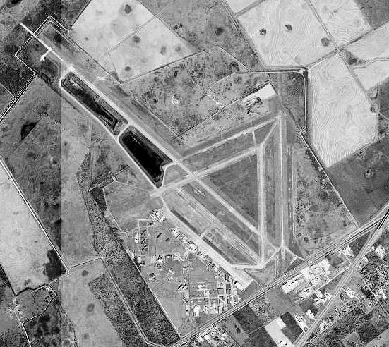
| Victoria Regional Airport, 27 Jan 1996 |
| IATA: VCT – ICAO: KVCT – FAA LID: VCT |
| Summary |
| Airport type |
Public |
| Operator |
County of Victoria |
| Location |
Victoria, Texas |
| Elevation AMSL |
115 ft / 35.1 m |
| Coordinates |
28°51′09″N 96°55′07″W / 28.8525°N 96.91861°W / 28.8525; -96.91861Coordinates: 28°51′09″N 96°55′07″W / 28.8525°N 96.91861°W / 28.8525; -96.91861 |
| Runways |
| Direction |
Length |
Surface |
| ft |
m |
| 12L/30R |
9,101 |
2,774 |
Asphalt |
| 12R/30L |
4,643 |
1,415 |
Concrete |
| 17/35 |
4,899 |
1,493 |
Asphalt |
| 6/24 |
4,200 |
1,280 |
Asphalt |
| Helipads |
| Number |
Length |
Surface |
| ft |
m |
| H1 |
60 |
18 |
Asphalt |
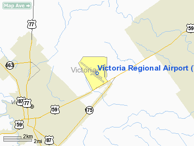
A twelve-ship formation over the Guadalupe River in the vicinity of Foster Field, Texas, Summer 1942 Victoria Regional Airport (IATA: VCT, ICAO: KVCT, FAA LID: VCT), formerly Foster Air Force Base, is a public airport located five miles (8 km) northeast of the central business district (CBD) of Victoria, in Victoria County, Texas, USA. The airport covers 1,766 acres (715 ha) and has four runways and one helipad. It is mostly used for general aviation, but is also served by one commercial airline. Service is subsidized by the Essential Air Service program. Airlines and destinations
| Airlines |
Destinations |
| Continental Connection operated by Colgan Air |
Houston-Intercontinental |
History
World War IIFoster Field began as a United States Army Air Forces (USAAF) facility that was established in 1941 as an advanced single-engine flying school for fighter pilots. Originally known as Victoria Field, it was renamed in 1942 in memory of 1st Lt Arthur L. Foster, a United States Army Air Corps instructor killed in a crash at Brooks Field in 1925. Foster's son received his training and commission at the base in the spring of 1942.
After World War II, Foster Field was deactivated and the site was returned to its private owners, the Buhler and Braman estates. It was later reactivated as an Air Force base from 1951-1958, during which time it operated F-86 Sabre and F-100 Super Sabre aircraft and served as Headquarters for 19th Air Force (19 AF). The base closed in Decmebr 1958 and formally inactivated in January 1959.
Post Military Use
The local economy suffered greatly from the closure of Foster AFB. In the summer of 1960, the General Services Administration approved the exchange of Aloe Field for Foster Field, and Victoria County Airport was moved to the latter site. The growth of the county airport slowly replaced the loss of Foster AFB as numerous businesses located there.
Two of the largest businesses to locate at Victoria County Airport were the Devereux Foundation, a therapeutic-education center, and Gary Aircraft, which repaired surplus C-54 Skymaster (Douglas DC-4) aircraft in 1968. In 1976 Foster became the site of Victoria Regional Airport, which provides passenger service and connections with major carriers.
The above content comes from Wikipedia and is published under free licenses – click here to read more.
Location & QuickFacts
| FAA Information Effective: | 2008-09-25 |
| Airport Identifier: | VCT |
| Airport Status: | Operational |
| Longitude/Latitude: | 096-55-06.5540W/28-51-09.2000N
-96.918487/28.852556 (Estimated) |
| Elevation: | 115 ft / 35.05 m (Surveyed) |
| Land: | 1766 acres |
| From nearest city: | 5 nautical miles NE of Victoria, TX |
| Location: | Victoria County, TX |
| Magnetic Variation: | 06E (1995) |
Owner & Manager
| Ownership: | Publicly owned |
| Owner: | County Of Victoria |
| Address: | Victoria Co Courthouse Rm 102
Victoria, TX 77901 |
| Phone number: | 361-575-4558 |
| Manager: | Larry Blackwell |
| Address: | 609 Foster Field Dr Suite F
Victoria, TX 77904 |
| Phone number: | 361-578-2704 |
Airport Operations and Facilities
| Airport Use: | Open to public |
| Wind indicator: | Yes |
| Segmented Circle: | Yes |
| Control Tower: | Yes |
| Lighting Schedule: | DUSK-DAWN
HIRL RY 12L/30R PRESET LOW INTST; TO INCR INTST & ACTVT MALSR RY 12L - CTAF. MIRL RY 17/35 PRESET MED INTST ONLY. PAPI RYS 30R, 17 & 35 OPERS CONTINUOUSLY. |
| Beacon Color: | Clear-Green (lighted land airport) |
| Landing fee charge: | No |
| Sectional chart: | Houston |
| Region: | ASW - Southwest |
| Boundary ARTCC: | ZHU - Houston |
| Tie-in FSS: | CXO - Montgomery County |
| FSS on Airport: | No |
| FSS Toll Free: | 1-800-WX-BRIEF
FOR FP FILING CALL CXO FSS 1-800-833-5602 |
| NOTAMs Facility: | VCT (NOTAM-d service avaliable) |
| Certification type/date: | I A S 09/1982
CLSD TO UNSCHEDULED ACR OPNS WITH MORE THAN 9 PSGR SEATS EXCP PPR CALL 361-578-2704; AFT HRS 361-575-0651. |
| Federal Agreements: | NGPY |
Airport Communications
| CTAF: | 126.075 |
| Unicom: | 122.700 |
Airport Services
| Fuel available: | 100LLA |
| Airframe Repair: | MINOR |
| Power Plant Repair: | MINOR |
Runway Information
Runway 06/24
| Dimension: | 4200 x 75 ft / 1280.2 x 22.9 m |
| Surface: | ASPH, Fair Condition |
| Weight Limit: | Single wheel: 28000 lbs.
Dual wheel: 49000 lbs.
Dual tandem wheel: 87000 lbs. |
| |
Runway 06 |
Runway 24 |
| Longitude: | 096-55-30.2880W | 096-54-46.6990W |
| Latitude: | 28-51-01.6580N | 28-51-17.6580N |
| Elevation: | 103.00 ft | 104.00 ft |
| Alignment: | 67 | 127 |
| Traffic Pattern: | Left | Left |
| Markings: | Basic, Good Condition | Basic, Good Condition |
| Obstruction: | 31 ft pline, 1600.0 ft from runway, 45:1 slope to clear | , 50:1 slope to clear |
| Decleard distances: | Take off run available 4200.00 ft
Take off distance available 4200.00 ft
Actual stop distance available 4200.00 ft
Landing distance available 4200.00 ft
| Take off run available 4200.00 ft
Take off distance available 4200.00 ft
Actual stop distance available 4200.00 ft
Landing distance available 4200.00 ft
|
|
Runway 12L/30R
| Dimension: | 9101 x 150 ft / 2774.0 x 45.7 m |
| Surface: | ASPH, Good Condition |
| Surface Treatment: | Saw-cut or plastic Grooved |
| Weight Limit: | Single wheel: 28000 lbs.
Dual wheel: 49000 lbs.
Dual tandem wheel: 87000 lbs. |
| Edge Lights: | High |
| |
Runway 12L |
Runway 30R |
| Longitude: | 096-56-02.6720W | 096-54-47.1640W |
| Latitude: | 28-51-49.4990N | 28-50-48.6790N |
| Elevation: | 115.00 ft | 103.00 ft |
| Alignment: | 127 | 127 |
| ILS Type: | ILS/DME
| |
| Traffic Pattern: | Left | Right |
| Markings: | Precision instrument, Good Condition | Non-precision instrument, Good Condition |
| Crossing Height: | 0.00 ft | 55.00 ft |
| VASI: | | 4-light PAPI on left side |
| Visual Glide Angle: | 0.00° | 3.00° |
| Approach lights: | MALSR | |
| Decleard distances: | Take off run available 9101.00 ft
Take off distance available 9101.00 ft
Actual stop distance available 9101.00 ft
Landing distance available 9101.00 ft
| Take off run available 9101.00 ft
Take off distance available 9101.00 ft
Actual stop distance available 9101.00 ft
Landing distance available 9101.00 ft
|
|
Runway 12R/30L
| Dimension: | 4643 x 150 ft / 1415.2 x 45.7 m |
| Surface: | CONC, Fair Condition |
| Weight Limit: | Single wheel: 28000 lbs.
Dual wheel: 49000 lbs.
Dual tandem wheel: 87000 lbs. |
| |
Runway 12R |
Runway 30L |
| Longitude: | 096-55-21.4060W | 096-54-42.8890W |
| Latitude: | 28-51-06.1920N | 28-50-35.1660N |
| Elevation: | 104.00 ft | 102.00 ft |
| Alignment: | 127 | 127 |
| Traffic Pattern: | Right | Left |
| Markings: | Basic, Good Condition | Basic, Fair Condition |
| Displaced threshold: | 431.00 ft | 551.00 ft |
| Obstruction: | , 50:1 slope to clear
APCH RATIO 50+:1 FROM DSPLCD THR. | 29 ft pole, 947.0 ft from runway, 64 ft left of centerline, 25:1 slope to clear
APCH RATIO 50+:1 FROM DSPLCD THR. |
| Decleard distances: | Take off run available 4643.00 ft
Take off distance available 4643.00 ft
Actual stop distance available 4643.00 ft
Landing distance available 4212.00 ft
| Take off run available 4643.00 ft
Take off distance available 4643.00 ft
Actual stop distance available 4643.00 ft
Landing distance available 4092.00 ft
|
|
Runway 17/35
| Dimension: | 4899 x 75 ft / 1493.2 x 22.9 m |
| Surface: | ASPH, Good Condition |
| Surface Treatment: | Saw-cut or plastic Grooved |
| Weight Limit: | Single wheel: 28000 lbs.
Dual wheel: 49000 lbs.
Dual tandem wheel: 87000 lbs. |
| Edge Lights: | Medium |
| |
Runway 17 |
Runway 35 |
| Longitude: | 096-54-35.1840W | 096-54-35.0610W |
| Latitude: | 28-51-32.1560N | 28-50-43.6590N |
| Elevation: | 106.00 ft | 103.00 ft |
| Alignment: | 127 | 127 |
| Traffic Pattern: | Left | Left |
| Markings: | Basic, Good Condition | Basic, Good Condition |
| Crossing Height: | 40.00 ft | 40.00 ft |
| VASI: | 2-light PAPI on left side | 2-light PAPI on left side |
| Visual Glide Angle: | 3.00° | 3.00° |
| Runway End Identifier: | Yes | Yes |
| Obstruction: | 6 ft fence, 400.0 ft from runway, 33:1 slope to clear | 29 ft pole, 1544.0 ft from runway, 44 ft left of centerline, 46:1 slope to clear |
| Decleard distances: | Take off run available 4899.00 ft
Take off distance available 4899.00 ft
Actual stop distance available 4899.00 ft
Landing distance available 4899.00 ft
| Take off run available 4899.00 ft
Take off distance available 4899.00 ft
Actual stop distance available 4899.00 ft
Landing distance available 4899.00 ft
|
|
Helipad H1
| Dimension: | 60 x 60 ft / 18.3 x 18.3 m |
| Surface: | ASPH, Good Condition |
| |
Runway H1 |
Runway |
| Traffic Pattern: | Left | Left |
|
Radio Navigation Aids
| ID |
Type |
Name |
Ch |
Freq |
Var |
Dist |
| PKV | NDB | Port Lavaca | | 515.00 | 05E | 17.4 nm |
| OKT | NDB | Yoakum | | 350.00 | 06E | 29.9 nm |
| MNO | NDB | Mellon Ranch | | 375.00 | 06E | 37.6 nm |
| RKP | NDB | Rockport | | 391.00 | 06E | 46.3 nm |
| ARM | NDB | Wharton | | 245.00 | 06E | 47.0 nm |
| VCT | VOR/DME | Victoria | 027X | 109.00 | 06E | 4.3 nm |
| PSX | VORTAC | Palacios | 120X | 117.30 | 08E | 32.7 nm |
Remarks
- RYS 06/24; 12R/30L & 17/35 NOT AVBL FOR ACR OPNS WITH MORE THAN 9 PSGR SEATS.
Images and information placed above are from
http://www.airport-data.com/airport/VCT/
We thank them for the data!
| General Info
|
| Country |
United States
|
| State |
TEXAS
|
| FAA ID |
VCT
|
| Latitude |
28-51-09.200N
|
| Longitude |
096-55-06.554W
|
| Elevation |
115 feet
|
| Near City |
VICTORIA
|
We don't guarantee the information is fresh and accurate. The data may
be wrong or outdated.
For more up-to-date information please refer to other sources.
|
|