 |
|
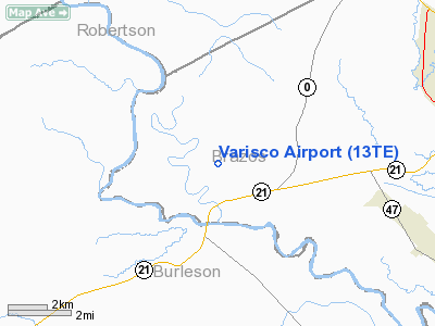
Location & QuickFacts
| FAA Information Effective: | 2008-09-25 |
| Airport Identifier: | 13TE |
| Airport Status: | Operational |
| Longitude/Latitude: | 096-32-17.8850W/30-39-21.7150N
-96.538301/30.656032 (Estimated) |
| Elevation: | 240 ft / 73.15 m (Estimated) |
| Land: | 15 acres |
| From nearest city: | 9 nautical miles W of Bryan, TX |
| Location: | Brazos County, TX |
| Magnetic Variation: | 06E (1985) |
Owner & Manager
| Ownership: | Privately owned |
| Owner: | Tony Varisco, Jr. |
| Address: | 5358 Steele Store Road
Bryan, TX 77809 |
| Phone number: | 409-823-0397 |
| Manager: | Tony Varisco, Jr. |
| Address: | 5358 Steele Store Road
Bryan, TX 77809 |
| Phone number: | 409-822-2135 |
Airport Operations and Facilities
| Airport Use: | Private |
| Wind indicator: | Yes |
| Segmented Circle: | No |
| Control Tower: | No |
| Landing fee charge: | No |
| Sectional chart: | Houston |
| Region: | ASW - Southwest |
| Boundary ARTCC: | ZHU - Houston |
| Tie-in FSS: | CXO - Montgomery County |
| FSS on Airport: | No |
| FSS Toll Free: | 1-800-WX-BRIEF
FOR FP FILING CALL CXO FSS 1-800-833-5602. |
Airport Services
| Fuel available: | 100LL |
| Airframe Repair: | NONE |
| Power Plant Repair: | NONE |
| Bottled Oxygen: | NONE |
| Bulk Oxygen: | NONE |
Runway Information
Runway 04/22
| Dimension: | 2330 x 100 ft / 710.2 x 30.5 m |
| Surface: | ASPH-TURF,
SW 827' OF RWY IS ASPH (CENTER 20' ONLY). |
| |
Runway 04 |
Runway 22 |
| Traffic Pattern: | Left | Left |
| Obstruction: | 20 ft bldg, 400.0 ft from runway, 100 ft right of centerline
+18' TANKS 7' FROM THR 104' RIGHT OF CNTRLN. +20' HANGAR 100' RIGHT OF CNTRLN. | , 50:1 slope to clear |
|
Radio Navigation Aids
| ID |
Type |
Name |
Ch |
Freq |
Var |
Dist |
| BNH | NDB | Brenham | | 362.00 | 06E | 27.4 nm |
| GYB | NDB | Lee County | | 385.00 | 07E | 37.1 nm |
| UTS | NDB | Huntsville | | 308.00 | 06E | 49.2 nm |
| CLL | VORTAC | College Station | 080X | 113.30 | 08E | 6.8 nm |
| TNV | VORTAC | Navasota | 106X | 115.90 | 08E | 33.3 nm |
| LOA | VORTAC | Leona | 045X | 110.80 | 08E | 40.7 nm |
| IDU | VORTAC | Industry | 039X | 110.20 | 08E | 42.1 nm |
Remarks
- ASPH COND-GOOD; TURF COND-GOOD.
- MAY BE EXEMPT UNDER GRANDFATHER CLAUSE.
Images and information placed above are from
http://www.airport-data.com/airport/13TE/
We thank them for the data!
| General Info
|
| Country |
United States
|
| State |
TEXAS
|
| FAA ID |
13TE
|
| Latitude |
30-39-21.715N
|
| Longitude |
096-32-17.885W
|
| Elevation |
240 feet
|
| Near City |
BRYAN
|
We don't guarantee the information is fresh and accurate. The data may
be wrong or outdated.
For more up-to-date information please refer to other sources.
|
|


