 |
|
Tyler Pounds Rgnl Airport |
| Tyler Pounds Regional Airport |
 |
| IATA: TYR – ICAO: KTYR |
| Summary |
| Airport type |
Public |
| Operator |
City of Tyler |
| Location |
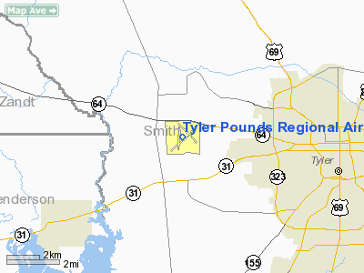
Smith County, near Tyler, Texas |
| Elevation AMSL |
544 ft / 165 m |
| Coordinates |
32°21′15.165″N 95°24′08.709″W / 32.3542125°N 95.40241917°W / 32.3542125; -95.40241917Coordinates: 32°21′15.165″N 95°24′08.709″W / 32.3542125°N 95.40241917°W / 32.3542125; -95.40241917 |
| Runways |
| Direction |
Length |
Surface |
| ft |
m |
| 4/22 |
7,199 |
2,194 |
Asphalt |
| 17/35 |
4,859 |
1,481 |
Asphalt |
| 13/31 |
5,201 |
1,585 |
Asphalt |
Tyler Pounds Regional Airport (IATA: TYR, ICAO: KTYR) is an airport located six miles west of Tyler, Texas (USA). The airport currently has three paved runways. In recent years, the airport has been expanding in order to meet goals outlined within "The Tyler Master Plan." On August 17, 2002, the airport opened a new terminal building, which doubled the available space.
Tyler Pounds Regional is a large center for General Aviation. The airport has three public parking lots for General Aviation arrivals. Commercial Service
American Eagle and Continental Connection currently offer service to and from Dallas-Fort Worth International Airport, in Dallas/Fort Worth, and George Bush Intercontinental Airport, in Houston. As of fall 2008, American Eagle operates Embraer ERJ 145 to Dallas-Fort Worth while Continental Connection continues to operate Saab 340B to George Bush Intercontinental Airport.
In early 2006, American Eagle announced it would be cutting flights to Tyler from eight per day to four per day in protest for the city of Tyler not taking the side of American Airlines in the battle over the Wright Amendment that involves Southwest Airlines hub in Dallas, Love Field Airport.
On November 11, 2008, Tyler-Pounds Regional airport has announced plans to add a fourth American Eagle regional jet departure from Tyler, starting January 6, 2009. The new American Eagle flight is expected to leave Dallas-Fort Worth International Airport at 4:40 pm and land in Tyler at 5:25 pm; then depart from Tyler at 5:50 pm and arrive back at Dallas-Fort Worth International Airport at 6:35 pm.
Continental Connection announced that it will be adding a daily flight to Tyler from George Bush Intercontinental Airport that will begin the same month as American Eagle plans to cut service from Dallas-Fort Worth International Airport.
Airlines and destinations
| Airlines |
Destinations |
| American Eagle |
Dallas/Fort Worth |
| Continental Connection operated by Colgan Air |
Houston-Intercontinental |
History
The airport was opened in November 1937 as Tyler Municipal Airport . During World War II the airfield was used by the United States Army Air Forces as a training base and renamed Pounds Field. At the end of the war the airfield was returned over to the local government for civil use and it was given its current name Tyler Pounds Regional Airport.
The Historic Aviation Memorial Museum (HAMM), a large aviation museum at the airport rented and moved into the old terminal building that has been closed since 2002.
The above content comes from Wikipedia and is published under free licenses – click here to read more.
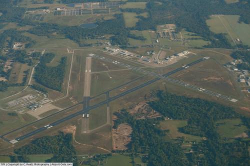 |
(Click on the photo to enlarge) |
Location & QuickFacts
| FAA Information Effective: | 2008-09-25 |
| Airport Identifier: | TYR |
| Airport Status: | Operational |
| Longitude/Latitude: | 095-24-08.5900W/32-21-14.9000N
-95.402386/32.354139 (Estimated) |
| Elevation: | 544 ft / 165.81 m (Surveyed) |
| Land: | 1200 acres |
| From nearest city: | 3 nautical miles W of Tyler, TX |
| Location: | Smith County, TX |
| Magnetic Variation: | 06E (1985) |
Owner & Manager
| Ownership: | Publicly owned |
| Owner: | City Of Tyler |
| Address: | Po Box 2039
Tyler, TX 75710 |
| Phone number: | 903-531-1250 |
| Manager: | Davis Dickson |
| Address: | 150 Airport Dr Suite 210
Tyler, TX 75704 |
| Phone number: | 903-531-2343 |
Airport Operations and Facilities
| Airport Use: | Open to public |
| Wind indicator: | Yes |
| Segmented Circle: | Yes |
| Control Tower: | Yes |
| Lighting Schedule: | DUSK-DAWN
WHEN ATCT CLSD ACTVT MIRL RYS 04/22 & 17/35, MALSR RY 13, ODALS RY 31, PAPI RY 04, VASI RYS 22 & 31 AND TWY LGTS - 120.1; HIRL RY 13/31 PRESET MED INTST, TO INCR INTST ACTVT - 120.1. |
| Beacon Color: | Clear-Green (lighted land airport) |
| Landing fee charge: | No |
| Sectional chart: | Dallas-ft Worth |
| Region: | ASW - Southwest |
| Boundary ARTCC: | ZFW - Fort Worth |
| Tie-in FSS: | FTW - Fort Worth |
| FSS on Airport: | No |
| FSS Phone: | 817-541-3474 |
| FSS Toll Free: | 1-800-WX-BRIEF |
| NOTAMs Facility: | TYR (NOTAM-d service avaliable) |
| Certification type/date: | I A S 05/1973 |
| Federal Agreements: | NGY3 |
Airport Communications
| CTAF: | 120.100 |
| Unicom: | 122.950 |
Airport Services
| Fuel available: | 100LLA |
| Airframe Repair: | MAJOR |
| Power Plant Repair: | MAJOR |
| Bottled Oxygen: | HIGH |
| Bulk Oxygen: | HIGH |
Runway Information
Runway 04/22
| Dimension: | 7200 x 150 ft / 2194.6 x 45.7 m |
| Surface: | ASPH, Good Condition |
| Surface Treatment: | Saw-cut or plastic Grooved |
| Weight Limit: | Single wheel: 40000 lbs.
Dual wheel: 60000 lbs.
Dual tandem wheel: 100000 lbs. |
| Edge Lights: | Medium |
| |
Runway 04 |
Runway 22 |
| Longitude: | 095-24-38.4790W | 095-23-39.0120W |
| Latitude: | 32-20-45.3990N | 32-21-35.6740N |
| Elevation: | 541.00 ft | 525.00 ft |
| Alignment: | 45 | 127 |
| Traffic Pattern: | Left | Left |
| Markings: | Non-precision instrument, Good Condition | Non-precision instrument, Good Condition |
| Crossing Height: | 45.00 ft | 50.00 ft |
| VASI: | 4-light PAPI on left side | 4-box on left side |
| Visual Glide Angle: | 3.00° | 3.00° |
| Runway End Identifier: | Yes | Yes |
| Obstruction: | , 50:1 slope to clear | 28 ft tree, 1146.0 ft from runway, 80 ft right of centerline, 33:1 slope to clear |
| Decleard distances: | Take off run available 7200.00 ft
Take off distance available 7200.00 ft
Actual stop distance available 7200.00 ft
Landing distance available 7200.00 ft
| Take off run available 7200.00 ft
Take off distance available 7200.00 ft
Actual stop distance available 7200.00 ft
Landing distance available 7200.00 ft
|
|
Runway 13/31
| Dimension: | 5200 x 150 ft / 1585.0 x 45.7 m |
| Surface: | ASPH, Good Condition |
| Surface Treatment: | Saw-cut or plastic Grooved |
| Weight Limit: | Single wheel: 40000 lbs.
Dual wheel: 60000 lbs.
Dual tandem wheel: 100000 lbs. |
| Edge Lights: | High |
| |
Runway 13 |
Runway 31 |
| Longitude: | 095-24-19.4860W | 095-23-36.7310W |
| Latitude: | 32-21-40.3780N | 32-21-03.9010N |
| Elevation: | 516.00 ft | 542.00 ft |
| Alignment: | 127 | 127 |
| ILS Type: | ILS
| |
| Traffic Pattern: | Left | Left |
| Markings: | Precision instrument, Good Condition | Precision instrument, Good Condition |
| Crossing Height: | 0.00 ft | 54.00 ft |
| VASI: | | 4-box on left side |
| Visual Glide Angle: | 0.00° | 3.00° |
| Approach lights: | MALSR | ODALS |
| Obstruction: | 28 ft pole, 1550.0 ft from runway, 550 ft right of centerline, 49:1 slope to clear | 14 ft road, 600.0 ft from runway, 520 ft right of centerline, 28:1 slope to clear |
| Decleard distances: | Take off run available 5200.00 ft
Take off distance available 5200.00 ft
Actual stop distance available 5200.00 ft
Landing distance available 5200.00 ft
| Take off run available 5200.00 ft
Take off distance available 5200.00 ft
Actual stop distance available 5200.00 ft
Landing distance available 5200.00 ft
|
|
Runway 17/35
| Dimension: | 4850 x 150 ft / 1478.3 x 45.7 m |
| Surface: | ASPH, Fair Condition |
| Weight Limit: | Single wheel: 40000 lbs.
Dual wheel: 60000 lbs.
Dual tandem wheel: 100000 lbs. |
| Edge Lights: | Medium |
| |
Runway 17 |
Runway 35 |
| Longitude: | 095-24-19.5550W | 095-24-19.7070W |
| Latitude: | 32-21-37.4450N | 32-20-49.4610N |
| Elevation: | 517.00 ft | 543.00 ft |
| Alignment: | 127 | 0 |
| Traffic Pattern: | Left | Left |
| Markings: | Basic, Good Condition | Basic, Good Condition |
| Obstruction: | 38 ft tree, 1100.0 ft from runway, 13 ft left of centerline, 23:1 slope to clear | 43 ft tree, 1158.0 ft from runway, 239 ft left of centerline, 30:1 slope to clear |
| Decleard distances: | Take off run available 4850.00 ft
Take off distance available 4850.00 ft
Actual stop distance available 4850.00 ft
Landing distance available 4850.00 ft
| Take off run available 4850.00 ft
Take off distance available 4850.00 ft
Actual stop distance available 4850.00 ft
Landing distance available 4850.00 ft
|
|
Radio Navigation Aids
| ID |
Type |
Name |
Ch |
Freq |
Var |
Dist |
| TY | NDB | Tyler | | 320.00 | 06E | 5.0 nm |
| ABG | NDB | Ambassador | | 404.00 | 07E | 20.2 nm |
| AHX | NDB | Athens | | 269.00 | 06E | 24.7 nm |
| HNO | NDB | Henderson | | 371.00 | 06E | 29.3 nm |
| JSO | NDB | Cherokee County | | 263.00 | 05E | 30.6 nm |
| CSZ | NDB | Crossroads | | 215.00 | 08E | 33.2 nm |
| LIQ | NDB | Lochridge Ranch | | 335.00 | 09E | 34.8 nm |
| PSN | NDB | Palestine | | 375.00 | 04E | 37.7 nm |
| LST | NDB | Lone Star | | 305.00 | 05E | 48.0 nm |
| AVZ | NDB | Travis | | 260.00 | 06E | 49.4 nm |
| TYR | VOR/DME | Tyler | 089X | 114.20 | 06E | 0.1 nm |
| FZT | VOR/DME | Frankston | 051X | 111.40 | 06E | 18.0 nm |
| UIM | VOR/DME | Quitman | 087X | 114.00 | 08E | 31.7 nm |
| GGG | VORTAC | Gregg County | 070X | 112.30 | 07E | 33.2 nm |
| CQY | VORTAC | Cedar Creek | 095X | 114.80 | 06E | 42.7 nm |
Remarks
- HELICOPTERS OPERATING INBOUND OR OUTBOUND TO/FROM THE DOWNTOWN HOSPITALS STATE INTENTION ON 123.075.
- CRANE 260 FT AGL 2 NM ESE OF RY 31 THLD; FLAGGED DAYTIME & LGTD NIGHTTIME.
Images and information placed above are from
http://www.airport-data.com/airport/TYR/
We thank them for the data!
| General Info
|
| Country |
United States
|
| State |
TEXAS
|
| FAA ID |
TYR
|
| Latitude |
32-21-14.900N
|
| Longitude |
095-24-08.590W
|
| Elevation |
544 feet
|
| Near City |
TYLER
|
We don't guarantee the information is fresh and accurate. The data may
be wrong or outdated.
For more up-to-date information please refer to other sources.
|
|


