 |
|
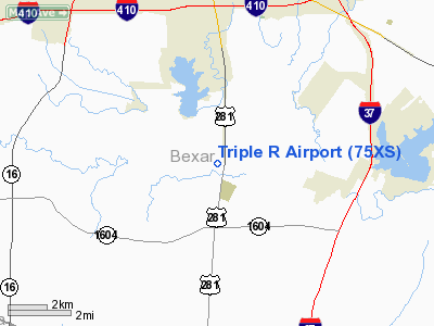
Location & QuickFacts
| FAA Information Effective: | 2008-09-25 |
| Airport Identifier: | 75XS |
| Airport Status: | Operational |
| Longitude/Latitude: | 098-28-34.0550W/29-14-57.8610N
-98.476126/29.249406 (Estimated) |
| Elevation: | 510 ft / 155.45 m (Estimated) |
| Land: | 18 acres |
| From nearest city: | 3 nautical miles S of San Antonio, TX |
| Location: | Bexar County, TX |
| Magnetic Variation: | 07E (1985) |
Owner & Manager
| Ownership: | Privately owned |
| Owner: | Thomas O Richardson |
| Address: | 1221 F.m. 2537
San Antonio, TX 78221 |
| Phone number: | 512-333-3940 |
| Manager: | Thomas O Richardson |
| Address: | 4207 Springview Drive
San Antonio, TX 78222 |
| Phone number: | 512-333-3940 |
Airport Operations and Facilities
| Airport Use: | Private |
| Wind indicator: | No |
| Segmented Circle: | No |
| Control Tower: | No |
| Landing fee charge: | No |
| Sectional chart: | San Antonio |
| Region: | ASW - Southwest |
| Boundary ARTCC: | ZHU - Houston |
| Tie-in FSS: | SJT - San Angelo |
| FSS on Airport: | No |
| FSS Toll Free: | 1-800-WX-BRIEF |
Airport Services
| Airframe Repair: | MINOR |
| Power Plant Repair: | MINOR |
Runway Information
Runway 02/20
| Dimension: | 2100 x 100 ft / 640.1 x 30.5 m |
| Surface: | TURF, Fair Condition |
| |
Runway 02 |
Runway 20 |
| Traffic Pattern: | Left | Left |
| Obstruction: | 15 ft tree, 50.0 ft from runway, 110 ft right of centerline, 3:1 slope to clear | 20 ft trees, 20.0 ft from runway, 25 ft right of centerline, 1:1 slope to clear |
|
Radio Navigation Aids
| ID |
Type |
Name |
Ch |
Freq |
Var |
Dist |
| PEZ | NDB | Pleasanton | | 275.00 | 07E | 17.8 nm |
| CVB | NDB | Castroville | | 338.00 | 08E | 20.4 nm |
| HHH | NDB | Devine | | 359.00 | 07E | 25.2 nm |
| HMA | NDB | Hondo | | 329.00 | 08E | 37.2 nm |
| ER | NDB | Shein | | 263.00 | 08E | 48.8 nm |
| KSY | TACAN | Kelly | 057X | | 07E | 10.2 nm |
| DHK | TACAN | Randolph | 036X | | 09E | 20.4 nm |
| SSF | VOR | Stinson | | 108.40 | 09E | 1.8 nm |
| HDO | VOR/DME | Hondo | 31X | 109.40 | 08E | 37.3 nm |
| RND | VORTAC | Randolph | 70X | 112.30 | 09E | 19.1 nm |
| SAT | VORTAC | San Antonio | 115X | 116.80 | 08E | 23.7 nm |
| THX | VORTAC | Three Rivers | 051X | 111.40 | 08E | 47.9 nm |
| SAT | VOT | San Antonio Intl | | 110.40 | | 17.1 nm |
Remarks
- CAUTION: 60' STRAIGHT DOWN DROP OFF INTO RIVER 20' FROM RWY 20 THR.
- VFR USE ONLY.
Images and information placed above are from
http://www.airport-data.com/airport/75XS/
We thank them for the data!
| General Info
|
| Country |
United States
|
| State |
TEXAS
|
| FAA ID |
75XS
|
| Latitude |
29-14-57.861N
|
| Longitude |
098-28-34.055W
|
| Elevation |
510 feet
|
| Near City |
SAN ANTONIO
|
We don't guarantee the information is fresh and accurate. The data may
be wrong or outdated.
For more up-to-date information please refer to other sources.
|
|


