 |
|
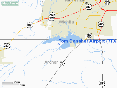
Location & QuickFacts
| FAA Information Effective: | 2008-09-25 |
| Airport Identifier: | 7TX0 |
| Airport Status: | Operational |
| Longitude/Latitude: | 098-34-21.9010W/33-49-41.4560N
-98.572750/33.828182 (Estimated) |
| Elevation: | 986 ft / 300.53 m (Surveyed) |
| Land: | 20 acres |
| From nearest city: | 5 nautical miles SW of Wichita Falls, TX |
| Location: | Archer County, TX |
| Magnetic Variation: | 10E (1965) |
Owner & Manager
| Ownership: | Privately owned |
| Owner: | Tom Danaher |
| Address: | Rt 3 Box 495
Wichita Falls, TX 76308 |
| Phone number: | 940-691-1111 |
| Manager: | Tom Danaher |
| Address: | Rt 3 Box 495
Wichita Falls, TX 76308 |
| Phone number: | 940-691-1111 |
Airport Operations and Facilities
| Airport Use: | Private |
| Wind indicator: | Yes |
| Segmented Circle: | No |
| Control Tower: | No |
| Landing fee charge: | No |
| Sectional chart: | Dallas-ft Worth |
| Region: | ASW - Southwest |
| Boundary ARTCC: | ZFW - Fort Worth |
| Tie-in FSS: | FTW - Fort Worth |
| FSS on Airport: | No |
| FSS Phone: | 817-541-3474 |
| FSS Toll Free: | 1-800-WX-BRIEF
LD TO FSS 855-5574. |
Airport Services
| Fuel available: | 100LL |
| Airframe Repair: | MAJOR |
| Power Plant Repair: | MAJOR |
| Bottled Oxygen: | NONE |
| Bulk Oxygen: | NONE |
Runway Information
Runway 17/35
| Dimension: | 3798 x 45 ft / 1157.6 x 13.7 m
SOUTH 400 FT CLSD INDEFLY. |
| Surface: | ASPH, Poor Condition
HAS HEAVY GRASS ENCROACHMENT ON BOTH SIDES. |
| Weight Limit: | Single wheel: 10000 lbs. |
| |
Runway 17 |
Runway 35 |
| Longitude: | 098-34-21.9130W | 098-34-21.9280W |
| Latitude: | 33-50-00.2770N | 33-49-22.7030N |
| Elevation: | 982.00 ft | 982.00 ft |
| Alignment: | 127 | 127 |
| Traffic Pattern: | Left | Left |
| Markings: | Numbers only, Poor Condition
17/35 MARKINGS FADED. | Numbers only, Poor Condition |
| Obstruction: | , 50:1 slope to clear
+4' FENCE AT THR 76' L; +4' FENCE 50' FM THR ACRS APCH; +5' FENCE 100' R OF CNTRLN AT THR; +25' TREES 125' R AT THR. | 3 ft fence, 200.0 ft from runway, 100 ft right of centerline
+15 FT TREE 42 FT FM RY END 65 FT R; +3 FT FENCE 100 FT R OF CNTRLN AT THLD; +10 FT BRUSH 50 FT L 125 FT FM THLD. |
|
Radio Navigation Aids
| ID |
Type |
Name |
Ch |
Freq |
Var |
Dist |
| SKB | NDB | Scotland | | 344.00 | 08E | 4.9 nm |
| ONY | NDB | Olney | | 272.00 | 07E | 31.2 nm |
| GHX | NDB | Graham | | 371.00 | 07E | 40.0 nm |
| GMZ | NDB | Grindstone Mountain | | 356.00 | 07E | 42.2 nm |
| VRT | NDB | Wilbarger | | 230.00 | 08E | 42.5 nm |
| PFL | NDB | Post | | 308.00 | 08E | 47.7 nm |
| SHP | TACAN | Sheppard | 045X | | 10E | 10.2 nm |
| LAW | VOR/DME | Lawton | 031X | 109.40 | 09E | 40.9 nm |
| DUC | VOR/DME | Duncan | 047X | 111.00 | 09E | 46.7 nm |
| SPS | VORTAC | Wichita Falls | 074X | 112.70 | 10E | 9.6 nm |
| UKW | VORTAC | Bowie | 071X | 112.40 | 06E | 41.5 nm |
Images and information placed above are from
http://www.airport-data.com/airport/7TX0/
We thank them for the data!
| General Info
|
| Country |
United States
|
| State |
TEXAS
|
| FAA ID |
7TX0
|
| Latitude |
33-49-41.456N
|
| Longitude |
098-34-21.901W
|
| Elevation |
986 feet
|
| Near City |
WICHITA FALLS
|
We don't guarantee the information is fresh and accurate. The data may
be wrong or outdated.
For more up-to-date information please refer to other sources.
|
|


