 |
|
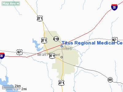
Titus Rgnl Medical Center Heliport |
Location & QuickFacts
| FAA Information Effective: | 2008-09-25 |
| Airport Identifier: | 2TS1 |
| Airport Status: | Operational |
| Longitude/Latitude: | 094-58-15.0000W/33-10-34.0000N
-94.970833/33.176111 (Estimated) |
| Elevation: | 422 ft / 128.63 m (Estimated) |
| Land: | 0 acres |
| From nearest city: | 1 nautical miles N of Mount Pleasant, TX |
| Location: | Titus County, TX |
| Magnetic Variation: | 05E (1990) |
Owner & Manager
| Ownership: | Privately owned |
| Owner: | Titus Regional Medical Center |
| Address: | 2001 N Jefferson
Mount Pleasant, TX 75455 |
| Phone number: | 903-577-6050 |
| Manager: | Wayne Ogburn
ADMINISTRATOR. |
| Address: | 2001 N Jefferson
Mount Pleansant, TX 75455 |
| Phone number: | 903-577-6050 |
Airport Operations and Facilities
| Airport Use: | Private
MEDICAL. |
| Wind indicator: | Yes |
| Segmented Circle: | No |
| Control Tower: | No |
| Lighting Schedule: | PHONE REQ
FOR PERIMETER LGTS CALL 903-577-6050. |
| Sectional chart: | Memphis |
| Region: | ASW - Southwest |
| Boundary ARTCC: | ZFW - Fort Worth |
| Tie-in FSS: | FTW - Fort Worth |
| FSS on Airport: | No |
| FSS Phone: | 817-541-3474 |
| FSS Toll Free: | 1-800-WX-BRIEF |
Runway Information
Helipad H1
| Dimension: | 25 x 25 ft / 7.6 x 7.6 m |
| Surface: | ASPH,
ROOFTOP. |
| |
Runway H1 |
Runway |
| Traffic Pattern: | Left | Left |
|
Radio Navigation Aids
| ID |
Type |
Name |
Ch |
Freq |
Var |
Dist |
| LST | NDB | Lone Star | | 305.00 | 05E | 18.8 nm |
| ABG | NDB | Ambassador | | 404.00 | 07E | 36.2 nm |
| ATA | NDB | Atlanta | | 347.00 | 04E | 39.5 nm |
| IBO | NDB | Idabel | | 271.00 | 03E | 44.3 nm |
| UIM | VOR/DME | Quitman | 087X | 114.00 | 08E | 26.7 nm |
| SLR | VOR/DME | Sulphur Springs | 027X | 109.00 | 08E | 28.8 nm |
| PRX | VOR/DME | Paris | 083X | 113.60 | 07E | 32.5 nm |
| GGG | VORTAC | Gregg County | 070X | 112.30 | 07E | 46.9 nm |
| TXK | VORTAC | Texarkana | 110X | 116.30 | 07E | 49.4 nm |
Remarks
- PRVDD PLINES TO SOUTH & EAST ARE RELOCATED TO PROVIDE A 8:1 SLOPE.
Images and information placed above are from
http://www.airport-data.com/airport/2TS1/
We thank them for the data!
| General Info
|
| Country |
United States
|
| State |
TEXAS
|
| FAA ID |
2TS1
|
| Latitude |
33-10-34.000N
|
| Longitude |
094-58-15.000W
|
| Elevation |
422 feet
|
| Near City |
MOUNT PLEASANT
|
We don't guarantee the information is fresh and accurate. The data may
be wrong or outdated.
For more up-to-date information please refer to other sources.
|
|


