 |
|
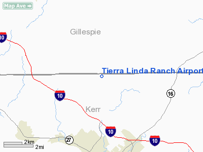
Tierra Linda Ranch Airport |
Location & QuickFacts
| FAA Information Effective: | 2008-09-25 |
| Airport Identifier: | 60TE |
| Airport Status: | Operational |
| Longitude/Latitude: | 099-09-01.1540W/30-08-00.7430N
-99.150321/30.133540 (Estimated) |
| Elevation: | 1990 ft / 606.55 m (Estimated) |
| Land: | 0 acres |
| From nearest city: | 6 nautical miles N of Kerrville, TX |
| Location: | Gillespie County, TX |
| Magnetic Variation: | 07E (1985) |
Owner & Manager
| Ownership: | Privately owned |
| Owner: | Tierra Linda Homeowners Assn |
| Address: | 389 Oak Alley
Kerrville, TX 78028 |
| Phone number: | 512-896-0510 |
| Manager: | Ricky Randall |
| Address: | 389 Oak Alley
Kerrville, TX 78028 |
| Phone number: | 830-257-4154 |
Airport Operations and Facilities
| Airport Use: | Private |
| Wind indicator: | Yes |
| Segmented Circle: | No |
| Control Tower: | No |
| Landing fee charge: | No |
| Sectional chart: | San Antonio |
| Region: | ASW - Southwest |
| Boundary ARTCC: | ZHU - Houston |
| Tie-in FSS: | SJT - San Angelo |
| FSS on Airport: | No |
| FSS Toll Free: | 1-800-WX-BRIEF |
Airport Communications
Airport Services
| Airframe Repair: | NONE |
| Power Plant Repair: | NONE |
Runway Information
Runway 16/34
| Dimension: | 3000 x 50 ft / 914.4 x 15.2 m |
| Surface: | ASPH, |
| |
Runway 16 |
Runway 34 |
| Traffic Pattern: | Left | Left |
|
Radio Navigation Aids
| ID |
Type |
Name |
Ch |
Freq |
Var |
Dist |
| ER | NDB | Shein | | 263.00 | 08E | 15.0 nm |
| HMA | NDB | Hondo | | 329.00 | 08E | 45.7 nm |
| MFS | NDB | Horseshoe Bay Resort | | 403.00 | 07E | 47.3 nm |
| CVB | NDB | Castroville | | 338.00 | 08E | 49.9 nm |
| HDO | VOR/DME | Hondo | 31X | 109.40 | 08E | 47.2 nm |
| CSI | VORTAC | Center Point | 122X | 117.50 | 08E | 13.1 nm |
| STV | VORTAC | Stonewall | 085X | 113.80 | 08E | 23.5 nm |
| LLO | VORTAC | Llano | 019X | 108.20 | 08E | 44.1 nm |
| JCT | VORTAC | Junction | 107X | 116.00 | 08E | 44.5 nm |
| SAT | VORTAC | San Antonio | 115X | 116.80 | 08E | 46.4 nm |
Remarks
- WATCH FOR DEER ON RY.
- RESTRICTED TO ASSN MEMBERS & THEIR GUESTS.
Images and information placed above are from
http://www.airport-data.com/airport/60TE/
We thank them for the data!
| General Info
|
| Country |
United States
|
| State |
TEXAS
|
| FAA ID |
60TE
|
| Latitude |
30-08-00.743N
|
| Longitude |
099-09-01.154W
|
| Elevation |
1990 feet
|
| Near City |
KERRVILLE
|
We don't guarantee the information is fresh and accurate. The data may
be wrong or outdated.
For more up-to-date information please refer to other sources.
|
|


