 |
|
| Terrell Municipal Airport |
 |
| IATA: TRL – ICAO: KTRL |
| Summary |
| Airport type |
City of Terrell, Texas |
| Operator |
474 |
| Location |
Terrell, Texas |
| Elevation AMSL |
144.5 ft / m |
| Coordinates |
32°42′33.04″N 096°16′02.609″W / 32.7091778°N 96.26739139°W / 32.7091778; -96.26739139Coordinates: 32°42′33.04″N 096°16′02.609″W / 32.7091778°N 96.26739139°W / 32.7091778; -96.26739139 |
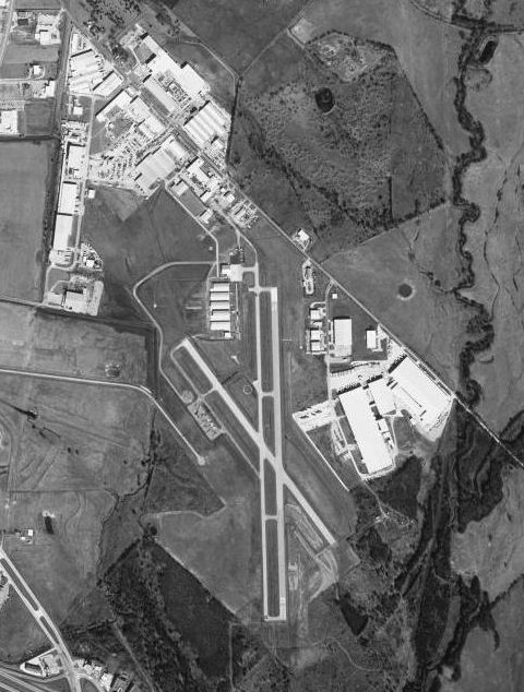
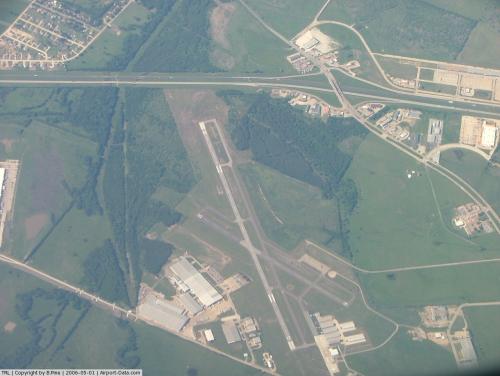
| Runways |
| Direction |
Length |
Surface |
| ft |
m |
| 17/35 |
5,006 |
1,526 |
Asphalt |
| 14/32 |
3,014 |
919 |
Asphalt |
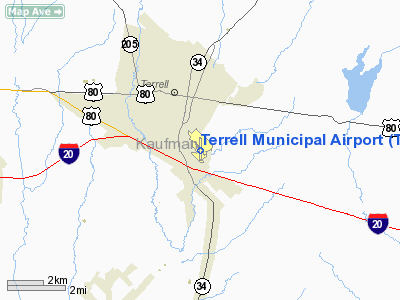
Terrell Municipal Airport (IATA: TRL, ICAO: KTRL) is a public access airport located within the city limits of Terrell, Texas, 1 mile SE of central Terrell.
The airport has services for commercial and private aviation. Aircraft operations, including local general aviation, transient general aviation, and air taxi, average 70 per day. The Airport Industrial Park is adjacent to the field.
It is owned and operated by the city of Terrell, Texas. History
The airport, actually only a grass field, was first used by a local flying club beginning in the Fall of 1940. In June 1941, the field was leased to Major William Long of Dallas, a civilian flight school operator, to be the home of the new No. 1 British Flying Training School, the first of seven British contract flight schools in the United States. This training was part of Lend-Lease aid where British Royal Air Force flying cadets were provided a 20-week flying course of 150 flight hours, taught by civilian instructors under the supervision of a Royal Air Force and civilian staff. Toward the end of the war the course had grown to a 32-week course of 220 hours. The new school, known as the Terrell Aviation School, offered flight training from primary through advanced instruction at the field. The school initially used the Stearman PT-18 primary trainer, the Vultee BT-13 basic trainer, and the AT-6 advanced trainer. After November 1943 the BT-13 was removed and students transitioned from the Stearman directly to the AT-6.
From November 1942 until June 1944, small numbers of American Army Air Forces flight cadets trained alongside the RAF students. During 1943 the school was expanded from 200 students to 300 students and two 3,000' asphalt hard surface runways were constructed by the Defense Plant Corporation (an agency of the US Government which had assumed ownership of the physical assets of all civiliam flight schools in the United States). These runways remain in use today, with 17/35 being extended to 5000' after the war.
British RAF pilot training at the airfield ended in early September 1945. With the end of World War II the airfield was determined to be excess by the military and turned over to the local government for civil use.
The above content comes from Wikipedia and is published under free licenses – click here to read more.
 |
(Click on the photo to enlarge) |
Location & QuickFacts
| FAA Information Effective: | 2008-09-25 |
| Airport Identifier: | TRL |
| Airport Status: | Operational |
| Longitude/Latitude: | 096-16-02.6090W/32-42-33.0410N
-96.267391/32.709178 (Estimated) |
| Elevation: | 474 ft / 144.48 m (Surveyed) |
| Land: | 400 acres |
| From nearest city: | 1 nautical miles SE of Terrell, TX |
| Location: | Kaufman County, TX |
| Magnetic Variation: | 04E (2005) |
Owner & Manager
| Ownership: | Publicly owned |
| Owner: | City Of Terrell |
| Address: | Po Box 310
Terrell, TX 75160 |
| Phone number: | 972-551-6604 |
| Manager: | Torry Edwards
CITY MANAGER. |
| Address: | Po Box 310
Terrell, TX 75160 |
| Phone number: | 972-551-6604 |
Airport Operations and Facilities
| Airport Use: | Open to public |
| Wind indicator: | Yes |
| Segmented Circle: | Yes |
| Control Tower: | No |
| Lighting Schedule: | DUSK-DAWN
ACTVT LDIN & PAPI RY 17 & PAPI RY 35 - CTAF. |
| Beacon Color: | Clear-Green (lighted land airport) |
| Landing fee charge: | No |
| Sectional chart: | Dallas-ft Worth |
| Region: | ASW - Southwest |
| Boundary ARTCC: | ZFW - Fort Worth |
| Tie-in FSS: | FTW - Fort Worth |
| FSS on Airport: | No |
| FSS Phone: | 817-541-3474 |
| FSS Toll Free: | 1-800-WX-BRIEF |
| NOTAMs Facility: | TRL (NOTAM-d service avaliable) |
| Federal Agreements: | NGRY |
Airport Communications
| CTAF: | 122.800 |
| Unicom: | 122.800 |
Airport Services
| Fuel available: | 100LLA |
| Airframe Repair: | MAJOR |
| Power Plant Repair: | MAJOR |
Runway Information
Runway 14/32
| Dimension: | 3014 x 75 ft / 918.7 x 22.9 m |
| Surface: | ASPH, Fair Condition |
| Weight Limit: | Single wheel: 12000 lbs. |
| Edge Lights: | Medium |
| |
Runway 14 |
Runway 32 |
| Longitude: | 096-16-14.3580W | 096-15-54.2240W |
| Latitude: | 32-42-49.3020N | 32-42-24.8150N |
| Elevation: | 472.00 ft | 468.00 ft |
| Alignment: | 127 | 127 |
| Traffic Pattern: | Left | Left |
| Markings: | Basic, Fair Condition | Basic, Good Condition |
| VASI: | 2-light PAPI on left side | 2-light PAPI on left side |
| Obstruction: | 8 ft road, 350.0 ft from runway, 145 ft right of centerline, 18:1 slope to clear | 18 ft trees, 392.0 ft from runway, 10 ft right of centerline, 10:1 slope to clear |
|
Runway 17/35
| Dimension: | 5006 x 75 ft / 1525.8 x 22.9 m |
| Surface: | ASPH, Good Condition |
| Weight Limit: | Single wheel: 12000 lbs. |
| Edge Lights: | Medium |
| |
Runway 17 |
Runway 35 |
| Longitude: | 096-16-01.5978W | 096-16-01.4856W |
| Latitude: | 32-42-55.3542N | 32-42-05.8155N |
| Elevation: | 474.00 ft | 456.00 ft |
| Alignment: | 127 | 127 |
| Traffic Pattern: | Left | Left |
| Markings: | Non-precision instrument, Good Condition | Non-precision instrument, Good Condition |
| VASI: | 4-light PAPI on left side | 4-light PAPI on left side |
| Approach lights: | LDIN | |
| Runway End Identifier: | Yes | Yes |
| Obstruction: | 57 ft tree, 1169.0 ft from runway, 267 ft right of centerline, 17:1 slope to clear | 32 ft trees, 1200.0 ft from runway, 31:1 slope to clear |
|
Radio Navigation Aids
| ID |
Type |
Name |
Ch |
Freq |
Var |
Dist |
| AVZ | NDB | Travis | | 260.00 | 06E | 3.2 nm |
| JUG | NDB | Jecca | | 388.00 | 06E | 13.6 nm |
| PQF | NDB | Mesquite | | 248.00 | 06E | 14.5 nm |
| SYW | NDB | Cash | | 428.00 | 05E | 19.3 nm |
| MII | NDB | Caddo Mills | | 316.00 | 06E | 19.9 nm |
| LNC | NDB | Lancaster | | 239.00 | 06E | 24.3 nm |
| RBD | NDB | Redbird | | 287.00 | 06E | 30.6 nm |
| XQH | NDB | Cedar Hill | | 353.00 | 08E | 36.6 nm |
| CGQ | NDB | Powell | | 344.00 | 06E | 39.6 nm |
| AHX | NDB | Athens | | 269.00 | 06E | 39.8 nm |
| CRS | NDB | Corsicana | | 396.00 | 06E | 41.5 nm |
| CSZ | NDB | Crossroads | | 215.00 | 08E | 41.9 nm |
| TY | NDB | Tyler | | 320.00 | 06E | 44.1 nm |
| LIQ | NDB | Lochridge Ranch | | 335.00 | 09E | 44.9 nm |
| MJF | TACAN | Arvilla | 033X | | 05E | 23.8 nm |
| CVE | VOR/DME | Cowboy | 109X | 116.20 | 06E | 34.0 nm |
| TTT | VOR/DME | Maverick | 078X | 113.10 | 06E | 40.2 nm |
| UIM | VOR/DME | Quitman | 087X | 114.00 | 08E | 46.7 nm |
| SLR | VOR/DME | Sulphur Springs | 027X | 109.00 | 08E | 46.9 nm |
| TYR | VOR/DME | Tyler | 089X | 114.20 | 06E | 48.7 nm |
| CQY | VORTAC | Cedar Creek | 095X | 114.80 | 06E | 31.6 nm |
| FUZ | VORTAC | Ranger | 104X | 115.70 | 06E | 47.3 nm |
| BYP | VORTAC | Bonham | 093X | 114.60 | 06E | 49.8 nm |
| DAL | VOT | Dallas Love Field | | 113.30 | | 30.7 nm |
Remarks
- BIRDS ON AND IN VICINITY OF AIRPORT.
Images and information placed above are from
http://www.airport-data.com/airport/TRL/
We thank them for the data!
| General Info
|
| Country |
United States
|
| State |
TEXAS
|
| FAA ID |
TRL
|
| Latitude |
32-42-36.168N
|
| Longitude |
096-16-02.723W
|
| Elevation |
474 feet
|
| Near City |
TERRELL
|
We don't guarantee the information is fresh and accurate. The data may
be wrong or outdated.
For more up-to-date information please refer to other sources.
|
|


