 |
|
| Taylor Municipal Airport |
| IATA: none – ICAO: none – FAA LID: T74 |
| Summary |
| Airport type |
Public |
| Owner |
City of Taylor |
| Serves |
Taylor, Texas |
| Elevation AMSL |
600 ft / 183 m |
| Coordinates |
30°34′22″N 097°26′36″W / 30.57278°N 97.44333°W / 30.57278; -97.44333 |
| Website |
www.TaylorMunicipalAirport.com |
| Runways |
| Direction |
Length |
Surface |
| ft |
m |
| 17/35 |
4,000 |
1,219 |
Asphalt |
| Statistics (2008) |
| Aircraft operations |
26,100 |
| Based aircraft |
11 |
| Source: Federal Aviation Administration |
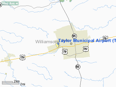
Taylor Municipal Airport (FAA LID: T74) is a city-owned public-use airport located two nautical miles (4 km) west of the central business district of Taylor, a city in Williamson County, Texas, United States.
The airport is located on Highway 79 and it is an important component of economic development for the City of Taylor and the region. The Texas Department of Transportation Aviation Division has classified the airport as a general utility business service airport.
Airport fly-in events are scheduled several times a year and include aircraft from all over the region.
Lodging, food, and ground transportation at or near the airport include: Best Western Hotel, Mas Fajitas Restaurant and Bar, and Enterprise Car Rental. History
Originally a grass airstrip built in the 1930s, the runway was paved in the 1970s. The airport was acquired by the City of Taylor in 1998. In 2000, the runway was expanded from 3,000 to 4,000 feet.
Facilities and aircraft
Taylor Municipal Airport covers an area of 106 acres (43 ha) at an elevation of 600 feet (183 m) above mean sea level. It has one runway designated 17/35 with a 4,000 by 75 ft (1,219 x 23 m) asphalt surface. For the 12-month period ending July 16, 2008, the airport had 26,100 aircraft operations, an average of 71 per day, all of which were100% general aviation. At that time there were 11 aircraft based at this airport: 91% single-engine and 9% multi-engine.
The above content comes from Wikipedia and is published under free licenses – click here to read more.
Location & QuickFacts
| FAA Information Effective: | 2008-09-25 |
| Airport Identifier: | T74 |
| Airport Status: | Operational |
| Longitude/Latitude: | 097-26-35.5000W/30-34-21.5000N
-97.443194/30.572639 (Estimated) |
| Elevation: | 600 ft / 182.88 m (Surveyed) |
| Land: | 106 acres |
| From nearest city: | 2 nautical miles W of Taylor, TX |
| Location: | Williamson County, TX |
| Magnetic Variation: | 05E (2010) |
Owner & Manager
| Ownership: | Publicly owned |
| Owner: | City Of Taylor |
| Address: | Po Box 810
Taylor, TX 76574 |
| Phone number: | 512-352-5990 |
| Manager: | Danny Thomas |
| Address: | 1 Airport Road
Taylor, TX 76574 |
| Phone number: | 512-352-5747 |
Airport Operations and Facilities
| Airport Use: | Open to public |
| Wind indicator: | Yes |
| Segmented Circle: | Yes |
| Control Tower: | No |
| Lighting Schedule: | DUSK-DAWN |
| Beacon Color: | Clear-Green (lighted land airport) |
| Landing fee charge: | No |
| Sectional chart: | San Antonio |
| Region: | ASW - Southwest |
| Boundary ARTCC: | ZHU - Houston |
| Tie-in FSS: | SJT - San Angelo |
| FSS on Airport: | No |
| FSS Toll Free: | 1-800-WX-BRIEF |
| NOTAMs Facility: | SJT (NOTAM-d service avaliable) |
| Federal Agreements: | NP |
Airport Communications
| CTAF: | 122.800 |
| Unicom: | 122.800 |
Airport Services
| Fuel available: | 100LLA |
| Airframe Repair: | MAJOR
HELICOPTER SERVICES ALSO AVBL. |
| Power Plant Repair: | MAJOR |
| Bottled Oxygen: | NONE |
| Bulk Oxygen: | NONE |
Runway Information
Runway 17/35
| Dimension: | 4000 x 75 ft / 1219.2 x 22.9 m |
| Surface: | ASPH, Good Condition |
| Weight Limit: | Single wheel: 12500 lbs. |
| Edge Lights: | Medium |
| |
Runway 17 |
Runway 35 |
| Longitude: | 097-26-36.0554W | 097-26-34.9845W |
| Latitude: | 30-34-41.2486N | 30-34-01.6753N |
| Elevation: | 600.00 ft | 548.00 ft |
| Alignment: | 127 | 127 |
| Traffic Pattern: | Right | Left |
| Markings: | Non-precision instrument, Good Condition | Non-precision instrument, Good Condition |
| Displaced threshold: | 0.00 ft | 249.00 ft |
| VASI: | nonstandard system
& RY 35 NSTD SINGLE BOX VASI ON LEFT SIDE. | nonstandard system |
| Runway End Identifier: | | No |
| Obstruction: | 26 ft pole, 1037.0 ft from runway, 145 ft left of centerline, 32:1 slope to clear
+5 FT BANK 100 FT R OF CNTRLN AT THLD. | 5 ft tree, 225.0 ft from runway, 15 ft right of centerline, 5:1 slope to clear
APCH RATIO 9:1 FM DSPLCD THLD TO TREES 280 FT FM DSPLCD THLD 250 FT LEFT.
+3 FT BRUSH 100-150 FT FM RY END ON RY CENTERLINE. +5-35 FT TREES FM RY END TO 200 FT , 150 FT LEFT. |
|
Radio Navigation Aids
| ID |
Type |
Name |
Ch |
Freq |
Var |
Dist |
| GUO | NDB | Georgetown | | 332.00 | 06E | 14.0 nm |
| IL | NDB | Iresh | | 278.00 | 07E | 30.4 nm |
| GYB | NDB | Lee County | | 385.00 | 07E | 34.2 nm |
| HLR | NDB | Hood | | 347.00 | 07E | 36.2 nm |
| BMQ | NDB | Burnet | | 341.00 | 07E | 42.2 nm |
| GR | NDB | Starn | | 323.00 | 07E | 42.2 nm |
| MFS | NDB | Horseshoe Bay Resort | | 403.00 | 07E | 47.4 nm |
| GRK | VOR/DME | Gray | 055X | 111.80 | 07E | 33.6 nm |
| TPL | VOR/DME | Temple | 041X | 110.40 | 09E | 38.3 nm |
| CWK | VORTAC | Centex | 075X | 112.80 | 06E | 12.5 nm |
Remarks
- NUMEROUS AGRICULTURAL OPNS INVOF ARPT DURG DALGT HRS.
- PAEW EAST SIDE OF ARPT.
Images and information placed above are from
http://www.airport-data.com/airport/T74/
We thank them for the data!
| General Info
|
| Country |
United States
|
| State |
TEXAS
|
| FAA ID |
T74
|
| Latitude |
30-34-19.000N
|
| Longitude |
097-26-35.400W
|
| Elevation |
590 feet
|
| Near City |
TAYLOR
|
We don't guarantee the information is fresh and accurate. The data may
be wrong or outdated.
For more up-to-date information please refer to other sources.
|
|


