|
|
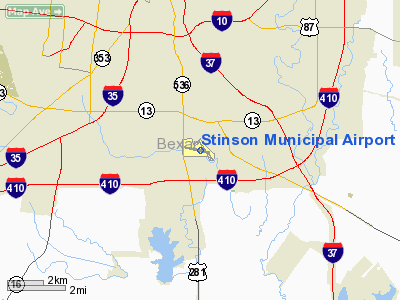
Stinson Municipal Airport
Stinson Field |
 |
| IATA: SSF – ICAO: KSSF |
| Summary |
| Airport type |
Public / Municipal |
| Owner |
City of San Antonio |
| Operator |
City of San Antonio Aviation Department |
| Serves |
San Antonio |
| Location |
San Antonio, Texas United States |
| Elevation AMSL |
577 ft / 175.9 m |
| Coordinates |
29°20′13.2270″N 98°28′16.1060″W / 29.3370075°N 98.47114056°W / 29.3370075; -98.47114056 |
| Website |
www.sanantonio.gov/aviation/ |
| Runways |
| Direction |
Length |
Surface |
| ft |
m |
| 14/32 |
4,129 |
|
Asphalt |
| 9/27 |
5,002 |
|
Asphalt |
| Helipads |
| Number |
Length |
Surface |
| ft |
m |
| H1 |
|
|
Asphalt |
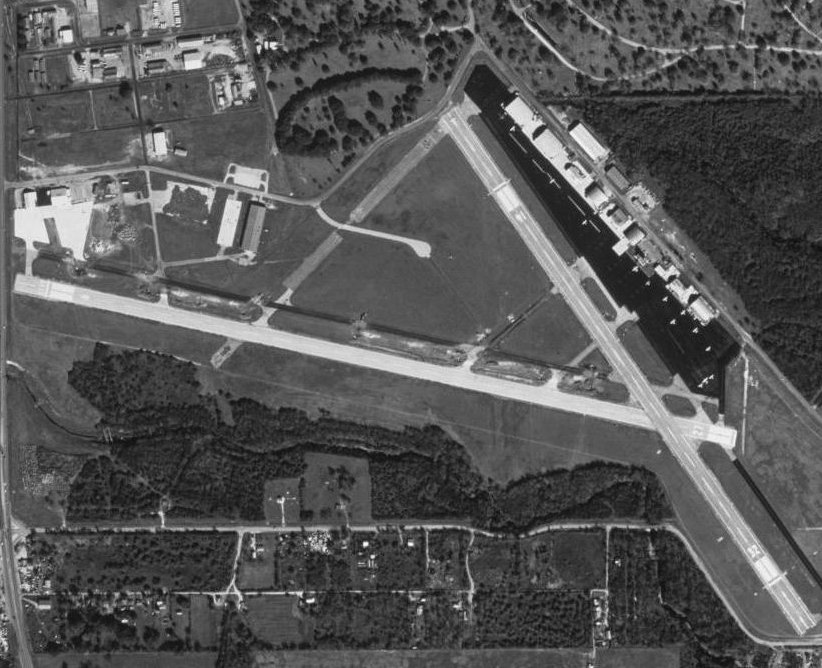
Stinson Municipal Airport (IATA: SSF, ICAO: KSSF), originally called Stinson Field, is a reliever airport located six miles south of downtown San Antonio’s central business district. The airport has two runways and its elevation is 577 feet (176 m) above sea level. History
Established in 1915 when the Stinson family initially leased the land from the City of San Antonio, Stinson Municipal Airport is the second oldest general aviation airport in continuous operation in the United States.
During World War II the airfield was used by the United States Army Air Forces as a training base. At the end of the war the airfield was returned over to the local government for civil use.
The airport currently has an FBO, two flight schools, police and state aviation units, a part 135 operator, two aerial photography outfits, and numerous general aviation aircraft. It is also home to the Texas Air Museum. The historic terminal was completely renovated in the 2006-2008 time period and runway 9-27 re-opened on March 11, 2010 after being re-surfaced and extended to 5002 feet, allowing the airfield to receive more private and business jet traffic.
The above content comes from Wikipedia and is published under free licenses – click here to read more.
Location & QuickFacts
| FAA Information Effective: | 2008-09-25 |
| Airport Identifier: | SSF |
| Airport Status: | Operational |
| Longitude/Latitude: | 098-28-16.1060W/29-20-13.2270N
-98.471141/29.337007 (Estimated) |
| Elevation: | 577 ft / 175.87 m (Surveyed) |
| Land: | 300 acres |
| From nearest city: | 6 nautical miles S of San Antonio, TX |
| Location: | Bexar County, TX |
| Magnetic Variation: | 08E (1980) |
Owner & Manager
| Ownership: | Publicly owned |
| Owner: | City Of San Antonio |
| Address: | 9800 Airport Blvd
San Antonio, TX 78216 |
| Phone number: | 210-207-3450 |
| Manager: | Jennifer Hogancamp |
| Address: | 8535 Mission Rd
San Antonio, TX 78214 |
| Phone number: | 210-923-4357 |
Airport Operations and Facilities
| Airport Use: | Open to public |
| Wind indicator: | Yes |
| Segmented Circle: | No |
| Control Tower: | Yes |
| Lighting Schedule: | DUSK-DAWN
MIRL RY 09/27 & 14/32 PRESET MED INTST WHEN ATCT CLSD. ACTVT VASI RY 32 - CTAF. |
| Beacon Color: | Clear-Green (lighted land airport) |
| Landing fee charge: | No |
| Sectional chart: | San Antonio |
| Region: | ASW - Southwest |
| Boundary ARTCC: | ZHU - Houston |
| Tie-in FSS: | SJT - San Angelo |
| FSS on Airport: | No |
| FSS Toll Free: | 1-800-WX-BRIEF |
| NOTAMs Facility: | SSF (NOTAM-d service avaliable) |
| Federal Agreements: | NGPY |
Airport Communications
| CTAF: | 118.200 |
| Unicom: | 122.950 |
Airport Services
| Fuel available: | 100LLA |
| Airframe Repair: | MAJOR |
| Power Plant Repair: | MAJOR |
| Bottled Oxygen: | NONE |
| Bulk Oxygen: | NONE |
Runway Information
Runway 09/27
| Dimension: | 4835 x 100 ft / 1473.7 x 30.5 m |
| Surface: | ASPH, Fair Condition |
| Weight Limit: | Single wheel: 12000 lbs.
Dual wheel: 20000 lbs. |
| Edge Lights: | Non-standard lighting system
NSTD MIRL; THLD LGTS LCTD 30 FT IN FM DSPLCD THLD. |
| |
Runway 09 |
Runway 27 |
| Longitude: | 098-28-51.3770W | 098-27-58.0590W |
| Latitude: | 29-20-18.7710N | 29-20-08.3870N |
| Elevation: | 577.00 ft | 564.00 ft |
| Alignment: | 103 | 127 |
| Traffic Pattern: | Left | Left |
| Markings: | Non-precision instrument, Fair Condition | Non-precision instrument, Fair Condition |
| Displaced threshold: | 206.00 ft | 0.00 ft |
| Runway End Identifier: | Yes
REIL LCTD 30 FT IN FM DSPLD THLD. | Yes |
| Obstruction: | 30 ft pline, 644.0 ft from runway, 14:1 slope to clear
APCH SLOPE 21:1 TO DSPLCD THLD FM +60 FT TREE AT 1286 FT FM DSPLCD THLD 100 FT RT OF CNTRLN.
+7 FT FENCE AT 25 FT; ROAD AT 75 FT ACROSS APCH. | , 50:1 slope to clear |
|
Runway 14/32
| Dimension: | 4128 x 100 ft / 1258.2 x 30.5 m |
| Surface: | ASPH, Good Condition |
| Weight Limit: | Single wheel: 12000 lbs.
Dual wheel: 20000 lbs. |
| Edge Lights: | Medium
NSTD MIRL; THLD LGTS LCTD 30 FT IN FM DSPLCD THLD. |
| |
Runway 14 |
Runway 32 |
| Longitude: | 098-28-19.2760W | 098-27-52.7690W |
| Latitude: | 29-20-29.6260N | 29-19-56.0040N |
| Elevation: | 571.00 ft | 552.00 ft |
| Alignment: | 127 | 127 |
| Traffic Pattern: | Left | Left |
| Markings: | Non-precision instrument, Good Condition | Non-precision instrument, Good Condition |
| Crossing Height: | 57.00 ft | 60.00 ft |
| Displaced threshold: | 584.00 ft | 372.00 ft |
| VASI: | 2-box on right side | 4-box on left side |
| Visual Glide Angle: | 4.00° | 3.00° |
| Runway End Identifier: | Yes
REIL OTS INDEFLY. | Yes |
| Obstruction: | 42 ft trees, 200.0 ft from runway, 75 ft right of centerline
APCH SLOPE 20:1 TO DSPLCD THLD +36 FT TREE AT 745 FT FM DSPLCD THLD 125 FT L.
+7 FT FENCE AT 21 FT; ROAD AT 52 FT ACROSS APCH. | 25 ft trees, 200.0 ft from runway
APCH SLOPE 25:1 TO DSPLCD THLD +40 FT TREE AT 1000 FT FM DSPLCD THLD 50 FT RIGHT OF CNTRLN.
+5 FT FENCE 75 FT FM THLD; ROAD AT THLD 100 FT L; +25 FT TREES 0 FT FM THLD 200 FT LEFT. |
|
Radio Navigation Aids
| ID |
Type |
Name |
Ch |
Freq |
Var |
Dist |
| CVB | NDB | Castroville | | 338.00 | 08E | 19.8 nm |
| PEZ | NDB | Pleasanton | | 275.00 | 07E | 23.1 nm |
| HHH | NDB | Devine | | 359.00 | 07E | 27.3 nm |
| HMA | NDB | Hondo | | 329.00 | 08E | 36.8 nm |
| ER | NDB | Shein | | 263.00 | 08E | 44.7 nm |
| KSY | TACAN | Kelly | 057X | | 07E | 6.6 nm |
| DHK | TACAN | Randolph | 036X | | 09E | 16.1 nm |
| SSF | VOR | Stinson | | 108.40 | 09E | 4.9 nm |
| HDO | VOR/DME | Hondo | 31X | 109.40 | 08E | 37.0 nm |
| RND | VORTAC | Randolph | 70X | 112.30 | 09E | 14.7 nm |
| SAT | VORTAC | San Antonio | 115X | 116.80 | 08E | 18.5 nm |
| SAT | VOT | San Antonio Intl | | 110.40 | | 11.8 nm |
Remarks
- NUMEROUS ACFT OPERATING AT OR ABOVE 2500 FT MSL IN THE STINSON ARPT TFC AREA UNDER THE CTL OF SAN ANTONIO APCH.
- PAEW ADJ ALL TWYS & RAMP AREAS MON-FRI 0700-1759.
Images and information placed above are from
http://www.airport-data.com/airport/SSF/
We thank them for the data!
| General Info
|
| Country |
United States
|
| State |
TEXAS
|
| FAA ID |
SSF
|
| Latitude |
29-20-13.227N
|
| Longitude |
098-28-16.106W
|
| Elevation |
577 feet
|
| Near City |
SAN ANTONIO
|
We don't guarantee the information is fresh and accurate. The data may
be wrong or outdated.
For more up-to-date information please refer to other sources.
|
|