 |
|
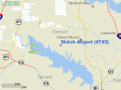
Location & QuickFacts
| FAA Information Effective: | 2008-09-25 |
| Airport Identifier: | 0TX5 |
| Airport Status: | Operational |
| Longitude/Latitude: | 097-07-11.0410W/33-01-26.4420N
-97.119734/33.024012 (Estimated) |
| Elevation: | 635 ft / 193.55 m (Estimated) |
| Land: | 0 acres |
| From nearest city: | 1 nautical miles NW of Flower Mound, TX |
| Location: | Denton County, TX |
| Magnetic Variation: | 07E (1985) |
Owner & Manager
| Ownership: | Privately owned |
| Owner: | John R. Todd |
| Address: | 5600 Wichita Trail
Flower Mound, TX 75028 |
| Phone number: | 817-430-1916 |
| Manager: | John R. Todd |
| Address: | 5600 Wichita Trail
Flower Mound, TX 75028 |
| Phone number: | 817-430-1916 |
Airport Operations and Facilities
| Airport Use: | Private |
| Wind indicator: | Yes |
| Segmented Circle: | No |
| Control Tower: | No |
| Sectional chart: | Dallas-ft Worth |
| Region: | ASW - Southwest |
| Boundary ARTCC: | ZFW - Fort Worth |
| Tie-in FSS: | FTW - Fort Worth |
| FSS Phone: | 817-541-3474 |
| FSS Toll Free: | 1-800-WX-BRIEF |
Runway Information
Runway 17/35
| Dimension: | 1800 x 50 ft / 548.6 x 15.2 m |
| Surface: | TURF, |
| |
Runway 17 |
Runway 35 |
| Traffic Pattern: | Left | Left |
| Obstruction: | 25 ft trees, 100.0 ft from runway | 5 ft fence, 100.0 ft from runway |
|
Radio Navigation Aids
| ID |
Type |
Name |
Ch |
Freq |
Var |
Dist |
| RBD | NDB | Redbird | | 287.00 | 06E | 24.3 nm |
| XQH | NDB | Cedar Hill | | 353.00 | 08E | 27.0 nm |
| PQF | NDB | Mesquite | | 248.00 | 06E | 32.5 nm |
| LNC | NDB | Lancaster | | 239.00 | 06E | 33.5 nm |
| JUG | NDB | Jecca | | 388.00 | 06E | 36.6 nm |
| GLE | NDB | Gainesville | | 330.00 | 06E | 41.9 nm |
| MII | NDB | Caddo Mills | | 316.00 | 06E | 43.9 nm |
| AVZ | NDB | Travis | | 260.00 | 06E | 46.7 nm |
| GMZ | NDB | Grindstone Mountain | | 356.00 | 07E | 47.9 nm |
| MWL | NDB | Mineral Wells | | 266.00 | 06E | 49.4 nm |
| NFW | TACAN | Nas Jrb Fort Worth | 024X | | 07E | 22.2 nm |
| TTT | VOR/DME | Maverick | 078X | 113.10 | 06E | 10.1 nm |
| CVE | VOR/DME | Cowboy | 109X | 116.20 | 06E | 13.5 nm |
| FUZ | VORTAC | Ranger | 104X | 115.70 | 06E | 8.6 nm |
| UKW | VORTAC | Bowie | 071X | 112.40 | 06E | 46.8 nm |
| MQP | VORTAC | Millsap | 124X | 117.70 | 09E | 47.8 nm |
| DAL | VOT | Dallas Love Field | | 113.30 | | 17.2 nm |
| FTW | VOT | Fort Worth Meacham | | 108.20 | | 17.3 nm |
Remarks
- PRVDD TFC PTN IS ESTABLISHED BLO 2000' MSL DUE TO TERMINAL CTL AREA FROM 2000' MSL UP TO & INCLUDING 8000' MSL & COMPATIBLE TFC PTNS ARE ESTABLISHED WITH WIND MILL HILL ARPT.
Images and information placed above are from
http://www.airport-data.com/airport/0TX5/
We thank them for the data!
| General Info
|
| Country |
United States
|
| State |
TEXAS
|
| FAA ID |
0TX5
|
| Latitude |
33-01-26.442N
|
| Longitude |
097-07-11.041W
|
| Elevation |
635 feet
|
| Near City |
FLOWER MOUND
|
We don't guarantee the information is fresh and accurate. The data may
be wrong or outdated.
For more up-to-date information please refer to other sources.
|
|


