 |
|
| Sherman Municipal Airport |
| IATA: none – ICAO: KSWI – FAA LID: SWI |
| Summary |
| Airport type |
Public |
| Owner |
City of Sherman |
| Serves |
Sherman, Texas |
| Elevation AMSL |
745 ft / 227 m |
| Coordinates |
33°37′27″N 096°35′10″W / 33.62417°N 96.58611°W / 33.62417; -96.58611 |
| Runways |
| Direction |
Length |
Surface |
| ft |
m |
| 16/34 |
4,006 |
1,221 |
Asphalt |
| Statistics (2007) |
| Aircraft operations |
13,800 |
| Based aircraft |
19 |
| Source: Federal Aviation Administration |
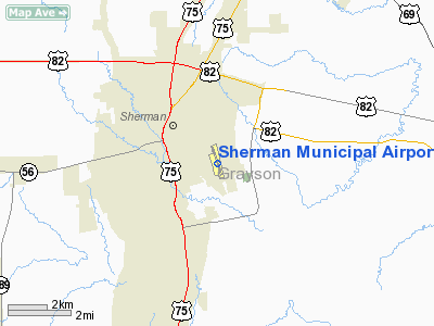
Sherman Municipal Airport (ICAO: KSWI, FAA LID: SWI) is a city-owned, public-use airport located one nautical mile (1.85 km) southeast of the central business district of Sherman, a city in Grayson County, Texas, United States.
Although many U.S. airports use the same three-letter location identifier for the FAA and IATA, this airport is assigned SWI by the FAA and no designation from the IATA (which assigned SWI to Swindon Airport in Swindon, England).
Facilities and aircraft
Sherman Municipal Airport covers an area of 144 acres (58 ha) at an elevation of 745 feet (227 m) above mean sea level. It has one runway designated 16/34 with an asphalt surface measuring 4,006 by 75 feet (1,221 x 23 m).
For the 12-month period ending April 30, 2007, the airport had 13,800 general aviation aircraft operations, an average of 37 per day. At that time there were 19 aircraft based at this airport: 95% single-engine and 5% multi-engine.
The above content comes from Wikipedia and is published under free licenses – click here to read more.
Location & QuickFacts
| FAA Information Effective: | 2008-09-25 |
| Airport Identifier: | SWI |
| Airport Status: | Operational |
| Longitude/Latitude: | 096-35-10.1010W/33-37-26.9810N
-96.586139/33.624161 (Estimated) |
| Elevation: | 745 ft / 227.08 m (Surveyed) |
| Land: | 144 acres |
| From nearest city: | 1 nautical miles SE of Sherman, TX |
| Location: | Grayson County, TX |
| Magnetic Variation: | 07E (1980) |
Owner & Manager
| Ownership: | Publicly owned |
| Owner: | City Of Sherman |
| Address: | Po Box 1106
Sherman, TX 75090 |
| Phone number: | 903-892-7035 |
| Manager: | Jeffrey Miller |
| Address: | Po Box 1106
Sherman, TX 75090 |
| Phone number: | 903-892-7035 |
Airport Operations and Facilities
| Airport Use: | Open to public |
| Wind indicator: | Yes |
| Segmented Circle: | Yes |
| Control Tower: | No |
| Lighting Schedule: | DUSK-DAWN |
| Beacon Color: | Clear-Green (lighted land airport) |
| Landing fee charge: | No |
| Sectional chart: | Dallas-ft Worth |
| Region: | ASW - Southwest |
| Traffic Pattern Alt: | 1055 ft |
| Boundary ARTCC: | ZFW - Fort Worth |
| Tie-in FSS: | FTW - Fort Worth |
| FSS on Airport: | No |
| FSS Phone: | 817-541-3474 |
| FSS Toll Free: | 1-800-WX-BRIEF |
| NOTAMs Facility: | FTW (NOTAM-d service avaliable) |
| Federal Agreements: | 1Y |
Airport Communications
| CTAF: | 122.800 |
| Unicom: | 122.800 |
Airport Services
| Fuel available: | 100LL
FUEL AVBL WITH MAJOR CREDIT CARD. |
| Airframe Repair: | MAJOR |
| Power Plant Repair: | MAJOR |
| Bottled Oxygen: | NONE |
| Bulk Oxygen: | NONE |
Runway Information
Runway 16/34
| Dimension: | 4006 x 75 ft / 1221.0 x 22.9 m |
| Surface: | ASPH, Good Condition |
| Weight Limit: | Single wheel: 19000 lbs. |
| Edge Lights: | Medium |
| |
Runway 16 |
Runway 34 |
| Longitude: | 096-35-15.8008W | 096-35-04.4019W |
| Latitude: | 33-37-46.2123N | 33-37-07.7496N |
| Elevation: | 745.00 ft | 711.00 ft |
| Alignment: | 127 | 127 |
| Traffic Pattern: | Left | Left |
| Markings: | Non-precision instrument, Good Condition | Non-precision instrument, Good Condition |
| Obstruction: | 15 ft tree, 500.0 ft from runway, 130 ft right of centerline, 20:1 slope to clear
+10 FT PLINE 40 FT FM THLD 250 FT RIGHT OF CNTRLN. | 41 ft tree, 278.0 ft from runway, 160 ft left of centerline, 1:1 slope to clear
+30 FT TREES 240 FT LEFT OF CNTRLN 20 FT FM THLD. |
|
Radio Navigation Aids
| ID |
Type |
Name |
Ch |
Freq |
Var |
Dist |
| DNI | NDB | Denison | | 341.00 | 06E | 12.7 nm |
| HJM | NDB | Rayburn | | 415.00 | 06E | 20.5 nm |
| DUA | NDB | Durant | | 359.00 | 05E | 21.3 nm |
| GLE | NDB | Gainesville | | 330.00 | 06E | 31.2 nm |
| MII | NDB | Caddo Mills | | 316.00 | 06E | 39.0 nm |
| AUV | NDB | Arbuckle | | 284.00 | 07E | 41.5 nm |
| SYW | NDB | Cash | | 428.00 | 05E | 46.6 nm |
| PQF | NDB | Mesquite | | 248.00 | 06E | 49.1 nm |
| MJF | TACAN | Arvilla | 033X | | 05E | 42.6 nm |
| URH | VOR/DME | Texoma | 090X | 114.30 | 05E | 21.5 nm |
| CVE | VOR/DME | Cowboy | 109X | 116.20 | 06E | 46.9 nm |
| BYP | VORTAC | Bonham | 093X | 114.60 | 06E | 18.4 nm |
| ADM | VORTAC | Ardmore | 114X | 116.70 | 06E | 45.7 nm |
| DAL | VOT | Dallas Love Field | | 113.30 | | 48.6 nm |
Remarks
- CITY ORDINANCE MANDATES ALL TAKE-OFFS ON RY 34 COMMENCE AT THLD MARKINGS. HIGH SPEED, LOW LEVEL PASSES ARE PROHIBITED.
Images and information placed above are from
http://www.airport-data.com/airport/SWI/
We thank them for the data!
| General Info
|
| Country |
United States
|
| State |
TEXAS
|
| FAA ID |
SWI
|
| Latitude |
33-37-26.983N
|
| Longitude |
096-35-10.066W
|
| Elevation |
745 feet
|
| Near City |
SHERMAN
|
We don't guarantee the information is fresh and accurate. The data may
be wrong or outdated.
For more up-to-date information please refer to other sources.
|
|


