|
|
| San Marcos Municipal Airport |
 |
| USGS aerial photo - 28 January 1995 |
| IATA: none – ICAO: KHYI – FAA LID: HYI |
| Summary |
| Airport type |
Public |
| Owner/Operator |
City of San Marcos |
| Serves |
San Marcos, Texas |
| Location |
San Marcos, Caldwell County, Texas, USA |
| Elevation AMSL |
597 ft / 182 m |
| Coordinates |
29°53′34″N 097°51′47″W / 29.89278°N 97.86306°W / 29.89278; -97.86306 |
| Runways |
| Direction |
Length |
Surface |
| ft |
m |
| 8/26 |
6,330 |
1,929 |
Asphalt |
| 13/31 |
5,603 |
1,708 |
Asphalt |
| 17/35 |
5,213 |
1,589 |
Asphalt |
| Statistics (2008) |
| Aircraft operations |
118,997 |
| Based aircraft |
108 |
| Source: Federal Aviation Administration |
 | |
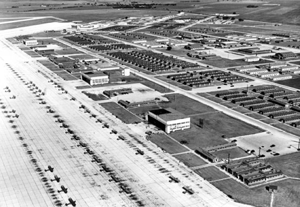
San Marcos Army Airfield, 1946, looking east along the flightline. |
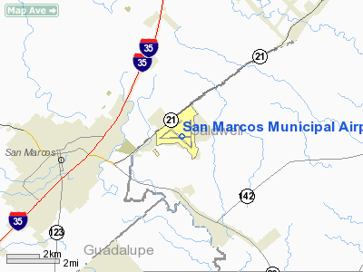
San Marcos Municipal Airport (ICAO: KHYI, FAA LID: HYI) is a public use airport located in Caldwell County, Texas, United States. It is four nautical miles (7 km) east of the central business district of San Marcos, a city that is mostly in Hays County. The airport is owned and operated by the City of San Marcos. It is located east of the border of Caldwell County and Hays County.
Although most U.S. airports use the same three-letter location identifier for the FAA and IATA, this airport is assigned HYI by the FAA but has no designation from the IATA. History
Shortly after the bombing of Pearl Harbor, San Marcos was selected as a training site for pilots and became the San Marcos Army Air Field. On 25 August 1943, the 80th Flying Training Wing (Navigation & Glider) was activated at San Marcos as part of Army Air Force Technical Training Command. Over a 2 year period, approximately 10,000 highly trained air navigators were trained there. Shortly after the end of hostilities with Japan, the Army Air Forces decided to consolidate all navigator training at Ellington Field near Houston. This consolidation occurred during September 1945, although the school at San Marcos remained open until November when the airfield was closed.
However, with the aid of Congressman Lyndon Johnson and Senator Tom Connally, the facility was reactivated in May 1946 to operate the Army Air Force helicopter and liaison school, which was transferred from Sheppard Field, Texas. With the change in status, San Marcos was reassigned to the Army Air Force Flying Training Command. With the establishment of the United States Air Force in 1947, the facility was renamed San Marcos Air Force Base. The 3585th Pilot Training Wing (Liaison-Helicopter) was activated as the Operational Training Unit on 25 August 1948. The wing remained active until 1 March 1949 when it was inactivated and helicopter training was moved from San Marcos to Waco (later James Connally) AFB. On 31 March, San Marcos AFB was inactivated.
On 15 January 1951, Air Training Command (ATC) reactivated San Marcos AFB and moved helicopter and liaison training back from Connally AFB. The availability of several small secondary airfields, as well as the hilly, rough terrain around San Marcos (similar to that of Korea) precipitated the change. In addition to the flying training, ATC moved ground helicopter mechanics training to San Marcos from Sheppard AFB to make room for its F-80 and F-89 training. On 1 February 1951, ATC reactivated and assigned the 3585th Pilot Training Wing (Liaison-Helicopter) to San Marcos. With nearly 5000 men on duty, the base was home to the largest helicopter training facility in the nation. It trained mechanics as well as pilots.
On Armed Forces Day, May 16, 1953, the base once again received a new name, the Edward Gary Air Force Base in honor of Lieutenant Arthur Edward Gary, the first Hays County soldier killed in World War II.
In 1956, the Department of Defense gave the Army approval to train helicopter pilots and operate liaison aircraft. To accommodate the transfer of training, the Air Force transferred Gary AFB to the Department of the Army in December 1956. Under Army control, the facility underwent yet another name change, one which is still referred to by some locals today, Camp Gary. A civilian contractor trained pilots for fixed wing aircraft until the summer of 1959. In 1963, the base was essentially closed and marked for disposal.
Organized San Marcans fought to save the base, and on November 20, 1964, President Lyndon B. Johnson announced in a speech at his alma mater, Southwest Texas State University, that the abandoned Camp Gary would be the site of a new federal vocational training facility called Job Corps. Today it's known as the Gary Job Corps Center, the largest in the nation.
Facilities and aircraft
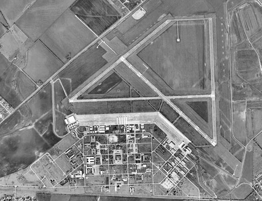
San Marcos Municipal Airport covers an area of 1,303 acres (527 ha) at an elevation of 597 feet (182 m) above mean sea level. It has three asphalt paved runways: 8/26 is 6,330 by 100 feet (1,929 x 30 m), 13/31 is 5,603 by 150 feet (1,708 x 46 m) and 17/35 is 5,213 by 100 feet (1,589 x 30 m).
For the 12-month period ending July 9, 2008, the airport had 118,997 aircraft operations, an average of 326 per day: 98% general aviation, 2% military and <1% air taxi. At that time there were 108 aircraft based at this airport: 76% single-engine, 20% multi-engine and 4% jet.
The above content comes from Wikipedia and is published under free licenses – click here to read more.
Location & QuickFacts
| FAA Information Effective: | 2008-09-25 |
| Airport Identifier: | HYI |
| Airport Status: | Operational |
| Longitude/Latitude: | 097-51-46.8150W/29-53-33.8920N
-97.863004/29.892748 (Estimated) |
| Elevation: | 597 ft / 181.97 m (Surveyed) |
| Land: | 1303 acres |
| From nearest city: | 4 nautical miles E of San Marcos, TX |
| Location: | Caldwell County, TX |
| Magnetic Variation: | 07E (1985) |
Owner & Manager
| Ownership: | Publicly owned |
| Owner: | City Of San Marcos |
| Address: | 630 E. Hopkins Street
San Marcos, TX 78666 |
| Phone number: | 512-393-8160 |
| Manager: | Scott Gallagher |
| Address: | 630 E. Hopkins
San Marcos, TX 78666 |
| Phone number: | 512-393-8160 |
Airport Operations and Facilities
| Airport Use: | Open to public |
| Wind indicator: | Yes |
| Segmented Circle: | Yes |
| Control Tower: | No |
| Lighting Schedule: | DUSK-DAWN
MIRL RYS 08/26, 13/31 & 17/35 PRESET LOW INTST; TO INCR INTST AND ACTVT MALSR RY 13; VASI RY 31; REIL RYS 08 & 26 - CTAF. |
| Beacon Color: | Clear-Green (lighted land airport) |
| Landing fee charge: | No |
| Sectional chart: | San Antonio |
| Region: | ASW - Southwest |
| Boundary ARTCC: | ZHU - Houston |
| Tie-in FSS: | SJT - San Angelo |
| FSS on Airport: | No |
| FSS Toll Free: | 1-800-WX-BRIEF |
| NOTAMs Facility: | HYI (NOTAM-d service avaliable) |
| Federal Agreements: | NGPY |
Airport Communications
| CTAF: | 123.050 |
| Unicom: | 123.050 |
Airport Services
| Fuel available: | 100LLA |
| Airframe Repair: | MAJOR |
| Power Plant Repair: | MAJOR |
| Bottled Oxygen: | LOW |
| Bulk Oxygen: | LOW |
Runway Information
Runway 08/26
| Dimension: | 6330 x 100 ft / 1929.4 x 30.5 m |
| Surface: | ASPH, Good Condition |
| Weight Limit: | Single wheel: 80000 lbs. |
| Edge Lights: | Medium |
| |
Runway 08 |
Runway 26 |
| Longitude: | 097-52-37.4940W | 097-51-25.6360W |
| Latitude: | 29-53-30.5010N | 29-53-32.8470N |
| Elevation: | 588.00 ft | 580.00 ft |
| Alignment: | 88 | 127 |
| Traffic Pattern: | Left | Left |
| Markings: | Non-precision instrument, Fair Condition | Non-precision instrument, Fair Condition |
| Runway End Identifier: | Yes | Yes |
| Obstruction: | 15 ft road, 660.0 ft from runway, 30:1 slope to clear | , 50:1 slope to clear |
|
Runway 13/31
| Dimension: | 5603 x 150 ft / 1707.8 x 45.7 m |
| Surface: | ASPH, Good Condition |
| Weight Limit: | Single wheel: 60000 lbs. |
| Edge Lights: | Medium |
| |
Runway 13 |
Runway 31 |
| Longitude: | 097-52-12.0950W | 097-51-25.4560W |
| Latitude: | 29-53-49.3200N | 29-53-11.5860N |
| Elevation: | 593.00 ft | 574.00 ft |
| Alignment: | 127 | 127 |
| ILS Type: | ILS
| |
| Traffic Pattern: | Left | Left |
| Markings: | Precision instrument, Good Condition | Precision instrument, Good Condition |
| Crossing Height: | 0.00 ft | 56.00 ft |
| VASI: | | 4-box on left side |
| Visual Glide Angle: | 0.00° | 3.00° |
| Approach lights: | MALSR | |
|
Runway 17/35
| Dimension: | 5213 x 100 ft / 1588.9 x 30.5 m |
| Surface: | ASPH, Good Condition |
| Weight Limit: | Single wheel: 20000 lbs. |
| Edge Lights: | Medium |
| |
Runway 17 |
Runway 35 |
| Longitude: | 097-51-27.8990W | 097-51-25.6990W |
| Latitude: | 29-54-06.0630N | 29-53-14.4960N |
| Elevation: | 594.00 ft | 574.00 ft |
| Alignment: | 127 | 127 |
| Traffic Pattern: | Left | Left |
| Markings: | Non-precision instrument, Good Condition | Non-precision instrument, Good Condition |
|
Radio Navigation Aids
| ID |
Type |
Name |
Ch |
Freq |
Var |
Dist |
| MFS | NDB | Horseshoe Bay Resort | | 403.00 | 07E | 45.8 nm |
| GUO | NDB | Georgetown | | 332.00 | 06E | 48.5 nm |
| GYB | NDB | Lee County | | 385.00 | 07E | 48.9 nm |
| DHK | TACAN | Randolph | 036X | | 09E | 30.1 nm |
| KSY | TACAN | Kelly | 057X | | 07E | 48.1 nm |
| SSF | VOR | Stinson | | 108.40 | 09E | 48.7 nm |
| RND | VORTAC | Randolph | 70X | 112.30 | 09E | 31.5 nm |
| CWK | VORTAC | Centex | 075X | 112.80 | 06E | 34.0 nm |
| SAT | VORTAC | San Antonio | 115X | 116.80 | 08E | 34.6 nm |
| STV | VORTAC | Stonewall | 085X | 113.80 | 08E | 47.7 nm |
| SAT | VOT | San Antonio Intl | | 110.40 | | 38.3 nm |
Remarks
- EQUIVALENT ARFF INDEX A EQUIPMENT AVBL ON REQUEST.
- 6'-8' CULTIVATION OCCASIONALLY OBSTRUCTS APCHS.
- EXPECT EXTENSIVE PRACTICE INSTRUMENT APPROACH TRAFFIC TO RY 13 AT ANY TIME.
- ESTABLISHED PRIOR TO 1940.
Images and information placed above are from
http://www.airport-data.com/airport/HYI/
We thank them for the data!
| General Info
|
| Country |
United States
|
| State |
TEXAS
|
| FAA ID |
HYI
|
| Latitude |
29-53-37.000N
|
| Longitude |
097-51-52.900W
|
| Elevation |
597 feet
|
| Near City |
SAN MARCOS
|
We don't guarantee the information is fresh and accurate. The data may
be wrong or outdated.
For more up-to-date information please refer to other sources.
|
|