|
 |
|
||||
|
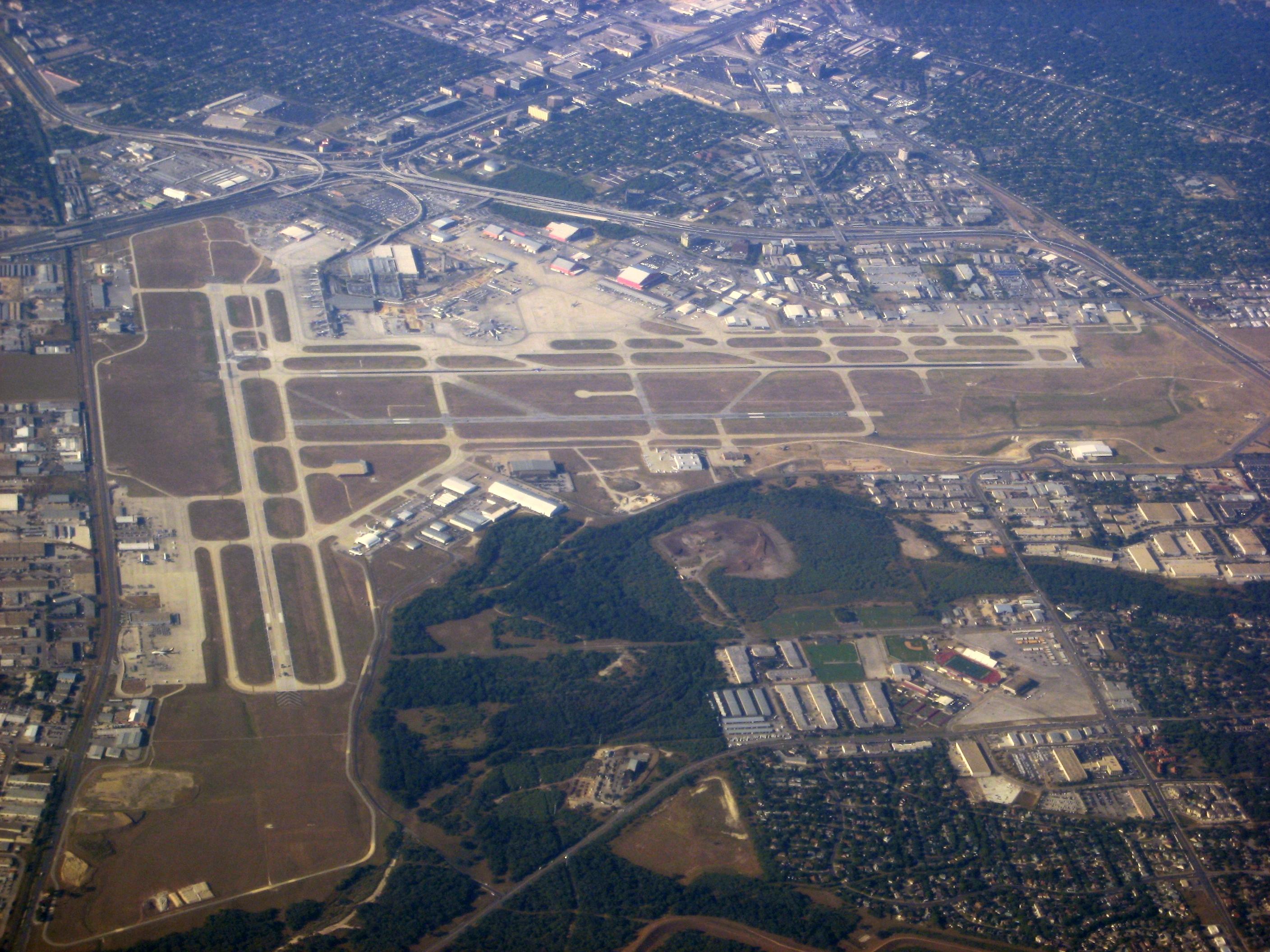
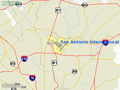
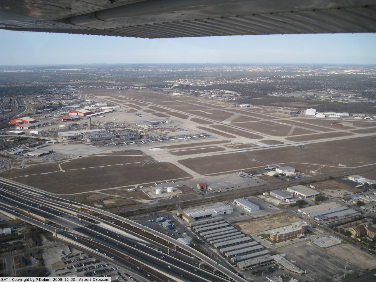
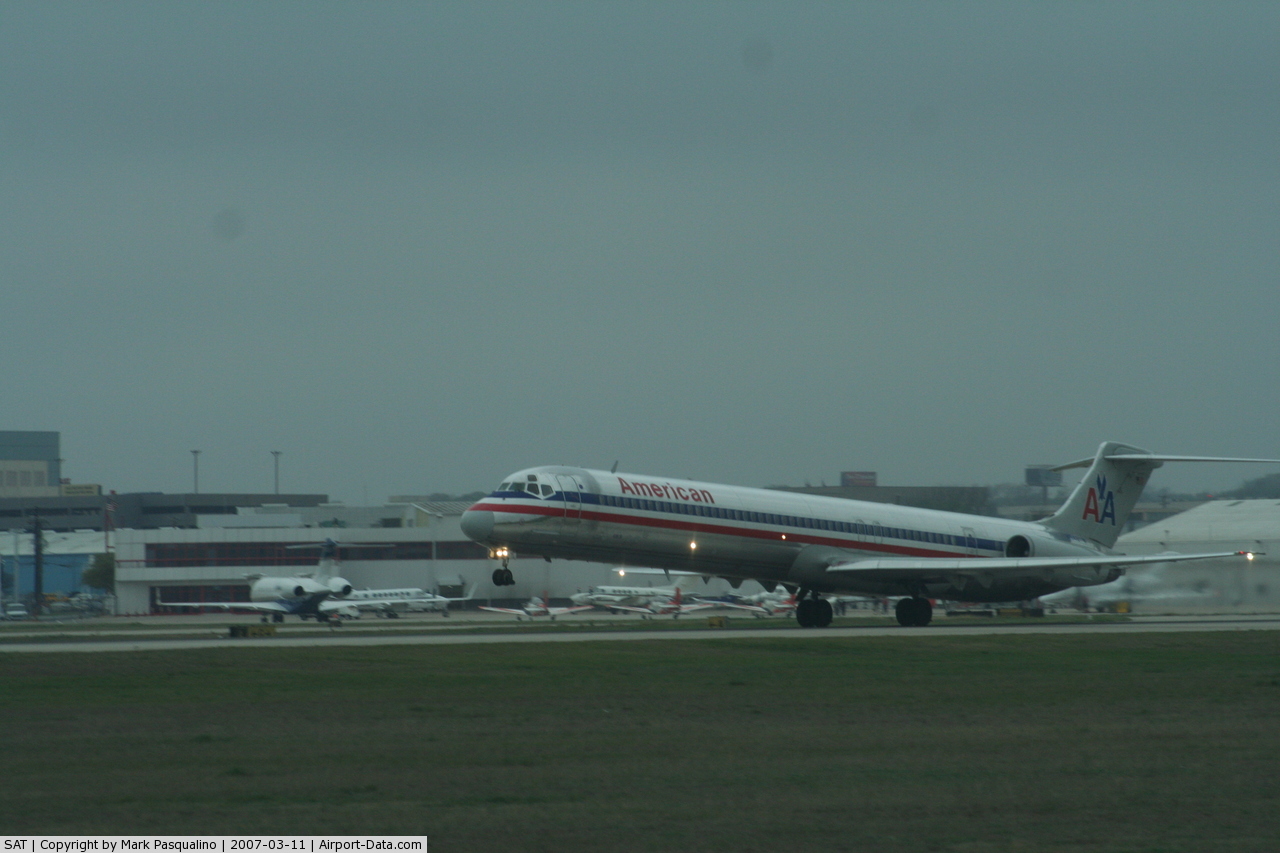
San Antonio International Airport (IATA: SAT, ICAO: KSAT, FAA LID: SAT) is a commercial airport in San Antonio, Texas, USA. The airport has three runways and covers 2,600 acres (1,100 ha). Its elevation is 809 feet (247 m) above sea level. SAT is a Class C airport. OverviewIn 2008, San Antonio International Airport handled 8,358,515 passengers, up 3.5 percent from the 2007 total, making this the airports fourth consecutive year of increasing passenger numbers. SAT averages 280 daily departures and arrivals at its 27 gates, which serve 16 airlines flying to 31 metro areas, including Mexico City. The airport's top-ranked destinations are Dallas, Houston, Las Vegas, Chicago, Baltimore, New York, Los Angeles, Phoenix, Atlanta and Washington, D.C. As of December 2006, Southwest Airlines is the airport's largest passenger air carrier, enplaning 35.24 percent of the airport's total passengers. American, Continental, and Northwest are the next three largest carriers. From February to September 2006, the airport was a "focus city" for United Airlines (which it called a 'hublet') with flights to 12 cities in conjunction with their partner Trans States Airlines. Trans States Airlines redeployed their aircraft elsewhere, eliminating service to seven cities. Mexicana celebrated 50 years serving the airport in September 2007, only to suspend service to San Antonio in August 2010 when the airline when bankrupt and suspended operations. The airport is undergoing a major, multi-million dollar expansion project which will add new terminals and parking facilities. The master plan for the project will increase gate capacity to 35. In addition, construction projects involving Interstate 410 and U.S. Highway 281 have improved access to the airport. (The airport sits near the northeast corner of the I-410/US 281 intersection.) Future plans also call for Stinson Municipal Airport, currently serving general aviation, to become the city's secondary commercial airport. Airport officials produce a 30-minute news program about once every quarter. "Airport Airwaves" airs on Tuesdays at 9 p.m., Wednesdays at 11 a.m., and Fridays at 1:30 p.m. on the Government Access cable channel. The longest flight (by flight time due to head winds) from San Antonio International Airport is to San Francisco International Airport, a distance of 1,482 miles, with an average duration of 3 hours 34 minutes. (Served by United Airlines, Canadair CRJ-700) The longest flight (by distance) from San Antonio International Airport is to Newark Liberty International Airport, a distance of 1,567 miles, with an average duration of 3 hours 1 minute. (Served by Continental Airlines, Boeing 737) The shortest flight from San Antonio International Airport is to Houston George Bush Intercontinental Airport, a distance of 191 miles, with an average duration of 50 minutes. (Served by Continental Airlines, Boeing 737 and Continental Express operated by ExpressJet Airlines, Embraer ERJ-145). HistorySan Antonio International Airport was founded in 1941 when the City of San Antonio purchased 1,200 acres (4.9 km) of undeveloped land north of the city limits for a project to be called “San Antonio Municipal Airport.” World War II Wartime needs meant the unfinished airport was pressed into government service. The airport was opened in July 1942 as Alamo Field and was used by the United States Army Air Forces as a training base. The 77th Reconnaissance Group, equipped with various aircraft (P-39, P-40, A-20, B-25, O-47, O-52, and L-5) trained reconnaissance personnel who later served overseas. One squadron (113th) flew antisubmarine patrols over the Gulf of Mexico. At the end of the war the airfield was not needed by the military and was turned over to the local government for civil use. The current Terminal 2, began construction in 1951 and was completed in 1953. In addition to the new terminal the FAA control tower and a baggage claim system were built. When news of the 1968 World Fair coming to San Antonio came, a new satellite concourse with eight jet bridge gates and passenger holding ares was built. In 1975, the city adopted its first Airport Master Plan. It included plans for a new 1,300 space parking garage, and a new 360,000 sq ft (33,000 m) Terminal (now called Terminal 1). Once the new terminal was completed in 1984, it brought the airport's capacity up from eight gates to 27 gates. In 1986, a new 221-foot (67 m) FAA Air Traffic Control Tower was built at a new location. In 1994, a second Airport Master Plan was developed that would take the airport well into the 21st century. This master plan included major updates for the airport. It called for more parking spaces made available through a new 3,000 space parking garage that would be completed by 2007. In addition it had plans for improved airport access, as well as an improved concession program. Two new terminals were planned to replace the aging Terminal 2, to increase the airports gate-capacity to 35. San Antonio closed the end of the 20th century with over 3.5 million passenger boardings in 1999. Since 1966, the airport has boarded more than 80 million people. Terminals, airlines and destinationsSan Antonio International Airport has two terminals with an overall 24 jet-bridge gates (as well as three seldom-used, common-use ground-loading gates). The original one-level terminal (now Terminal 2) opened in 1953 with ground-loading holding areas and was expanded twice, once in 1959 with new east and west wings and again in 1968 with an eight-gate satellite concourse, which was built to handle visitors to HemisFair '68. A second terminal (now Terminal 1) opened in 1984 with a 16-gate concourse. The U.S. Customs Federal Inspection Station (FIS) is located in Terminal 1. Gates 1-2 and 10-11 have direct access to the FIS. There is a gap in gate numbers between the two terminals. Terminal 1 has gates numbered 1-16, and Terminal 2's gates are numbered 30-41. Gate numbers 17-29 were to be used in a concourse planned for the western end of Terminal 1, which will now be built as the new Terminal B. A two-level parking garage immediately across from Terminal 1 opened in 1982, and the five-level parking garage opened in 1999. Completion of an expansion of the five-level parking garage was completed in mid 2008. The FAA control tower became operational in 1986. Public transportation to and from the airport is provided by VIA bus #5. Passenger operations
Cargo operations
ExpansionAn expansion program began in 2006 to add additional parking, two new terminals, and roadway improvements. The plan calls for the recently renovated Terminal 2 to be razed after a new two-level 8-gate concourse is completed in 2010. Terminal 1 will then be renamed Terminal A, and the new concourse will be named Terminal B. Another new terminal, Terminal C, will then be constructed beginning in 2012. It will include five gates and will subsequently be expanded to 11 gates as passenger counts require. Terminal C should be completed in 2015, bringing San Antonio's total number of jet-bridge gates to 28. This number will eventually increase to 35 gates as Terminal C is expanded. There are preliminary plans for Terminal D, which could have up to 20 gates, to be built as needed. The bi-level roadway in front of Terminal 1 is also being extended to provide service to the new terminals. A 1,100,000-square-foot (102,000 m) 3,000-space expansion to the existing five-level long-term parking garage was completed in mid 2008. Various ancillary utility projects and upgrades are also being performed as part of this program. To see a map of the construction click here. Other operationsThe San Antonio Spurs' charter Champion Air used SAT but the airline ceased operations in May 2008. San Antonio Aerospace occasionally receives VIP aircraft under maintenance contracts. They also maintain commercial airline aircraft. San Antonio airport houses the flight operations for Seven Q Seven which operates a modified 707 in-air tanker. Its hangar is along Wetmore Road. The plane is gray with tail number OMEGA71. San Antonio receives a share of Dallas- and Houston-area diverted flights during bad weather. These diversions are more frequent during the thunderstorm-prone summer months than during the winter months. Past visitors have included trans-Atlantic flights. Incidents and accidentsOn January 31, 1967, a Saturn Airways DC-6 was operating on a cargo flight to Kelly AFB. The crew decided to divert to San Antonio International Airport and commenced the approach. The airplane descended 1100 feet below the glide slope, flew through trees and collided with a cliff. The above content comes from Wikipedia and is published under free licenses – click here to read more.
Location & QuickFacts
Owner & Manager
Airport Operations and Facilities
Airport Communications
Airport Services
Runway InformationRunway 03/21
Runway 12L/30R
Runway 12R/30L
Radio Navigation Aids
Remarks
Images and information placed above are from We thank them for the data!
We don't guarantee the information is fresh and accurate. The data may
be wrong or outdated.
|
|||||||||||||||||||||||||||||||||||||||||||||||||||||||||||||||||||||||||||||||||||||||||||||||||||||||||||||||||||||||||||||||||||||||||||||||||||||||||||||||||||||||||||||||||||||||||||||||||||||||||||||||||||||||||||||||||||||||||||||||||||||||||||||||||||||||||||||||||||||||||||||||||||||||||||||||||||||||||||||||||||||||||||||||||||||||||||||||||||||||||||||||||||||||||||||||||||||||||||||||||||||||||||||||||||||||||||||||||||||||||||||||||||||||||||||||||||||||||||||||||||||||||||||||||||||||||||||||||||||||||||||||||||||||||||||||||||||||||||||||||||||

 |
|
Copyright 2004-2026 © by Airports-Worldwide.com, Vyshenskoho st. 36, Lviv 79010, Ukraine Legal Disclaimer |