 |
|
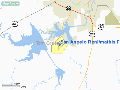
San Angelo Rgnl/mathis Field Airport |
San Angelo Regional Airport
Mathis Field |
 |
| IATA: SJT – ICAO: KSJT – FAA LID: SJT |
| Summary |
| Airport type |
Public |
| Operator |
City of San Angelo |
| Location |
San Angelo, Texas |
| Elevation AMSL |
1,919 ft / 584.9 m |
| Coordinates |
31°21′28″N 100°29′47″W / 31.35778°N 100.49639°W / 31.35778; -100.49639Coordinates: 31°21′28″N 100°29′47″W / 31.35778°N 100.49639°W / 31.35778; -100.49639 |
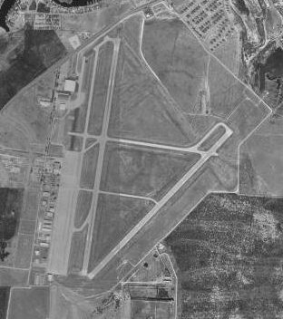
| Runways |
| Direction |
Length |
Surface |
| ft |
m |
| 18/36 |
8,049 |
2,453 |
Asphalt |
| 3/21 |
5,939 |
1,810 |
Asphalt |
| 9/27 |
4,402 |
1,342 |
Asphalt |
San Angelo Regional Airport (IATA: SJT, ICAO: KSJT, FAA LID: SJT), also known as Mathis Field, is a public airport serving the city of San Angelo, in Tom Green County, Texas, USA. The airport covers 1,503 acres (608 ha) and has three runways. The airport also offers free parking. Airlines
| Airlines |
Destinations |
| American Eagle |
Dallas/Fort Worth |
| American Eagle operated by Executive Airlines |
Dallas/Fort Worth |
History
The airport, originally named Carr Field, was built in 1941 by the United States Army Air Forces as a pilot training airfield. Activated on 1 June 1942, the airfield was assigned to the AAF Gulf Coast Training Center, with the Army Air Force Pilot School (Bomber and Specialized 2/4-Engine) activated (phase 3 pilot training). The school's mission was to train cadets to fly transports and bombers. Pilot wings were awarded upon graduation and were sent on to group combat training by First, Second, Third or Fourth Air Force. Graduates were usually graded as Flight Officers (Warrant Officers); cadets who graduated at the top of their class were graded as Second Lieutenants.
On 8 January 1943, the War Department constituted and activated the 34th Flying Training Wing (Bomber and Specialized 2/4-Engine) at Carr and assigned it to the AAF Central Flying Training Command.
Training ended at the end of World War II, and the airfield was inactivated on 30 November 1945. It was transferred to the jurisdiction of the Army Corps of Engineers on 30 June 1946. Later the facility was disposed of by the War Assets Administration (WAA) and deeded to the local government.
The airport was later renamed in honor of local Jack W. Mathis, a bombardier who received the Medal of Honor.
The above content comes from Wikipedia and is published under free licenses – click here to read more.
Location & QuickFacts
| FAA Information Effective: | 2008-09-25 |
| Airport Identifier: | SJT |
| Airport Status: | Operational |
| Longitude/Latitude: | 100-29-46.7000W/31-21-27.9000N
-100.496306/31.357750 (Estimated) |
| Elevation: | 1919 ft / 584.91 m (Surveyed) |
| Land: | 1503 acres |
| From nearest city: | 7 nautical miles SW of San Angelo, TX |
| Location: | Tom Green County, TX |
| Magnetic Variation: | 09E (1980) |
Owner & Manager
| Ownership: | Publicly owned |
| Owner: | City Of San Angelo
AIRPORT DIRECTOR. |
| Address: | Box 1751
San Angelo, TX 76902 |
| Phone number: | 325-657-4241 |
| Manager: | Luis E. Elguezabal |
| Address: | 8618 Terminal Circle Suite 101
San Angelo, TX 78904
SUITE 101. |
| Phone number: | 325-659-6409
EXTENSION 3. |
Airport Operations and Facilities
| Airport Use: | Open to public |
| Wind indicator: | Yes |
| Segmented Circle: | Yes |
| Control Tower: | Yes |
| Lighting Schedule: | DUSK-DAWN
WHEN ATCT CLSD MIRL RY 18/36 PRESET LOW INTST; TO INCR INTST & ACTVT HIRL RY 03/21, MIRL RY 09/27, MALSR RY 03, ODALS RY 21, REIL RY 18, PAPI RYS 18 & 36 - 118.3. |
| Beacon Color: | Clear-Green (lighted land airport) |
| Landing fee charge: | No |
| Sectional chart: | San Antonio |
| Region: | ASW - Southwest |
| Boundary ARTCC: | ZFW - Fort Worth |
| Tie-in FSS: | SJT - San Angelo |
| FSS on Airport: | No |
| FSS Toll Free: | 1-800-WX-BRIEF |
| NOTAMs Facility: | SJT (NOTAM-d service avaliable) |
| Certification type/date: | I B S 05/1973
PPR 12 HRS FOR UNSKED ACR OPNS WITH OVER 30 PSGR SEATS CALL AMGR 325-659-6409, EXTN 3. |
| Federal Agreements: | NGPY |
Airport Communications
| CTAF: | 118.300 |
| Unicom: | 122.950 |
Airport Services
| Fuel available: | 100LLA B+
FEE FOR FUEL AFT HRS CALL 325-656-1836/1837. 100LL SELF FUEL AVBL 24 HRS. |
| Airframe Repair: | MAJOR |
| Power Plant Repair: | MAJOR |
| Bottled Oxygen: | LOW |
| Bulk Oxygen: | HIGH/LOW |
Runway Information
Runway 03/21
| Dimension: | 5939 x 150 ft / 1810.2 x 45.7 m |
| Surface: | ASPH, Good Condition |
| Surface Treatment: | Saw-cut or plastic Grooved |
| Weight Limit: | Single wheel: 70000 lbs.
Dual wheel: 100000 lbs. |
| Edge Lights: | High |
| |
Runway 03 |
Runway 21 |
| Longitude: | 100-29-59.5234W | 100-29-12.6821W |
| Latitude: | 31-20-58.9348N | 31-21-41.8119N |
| Elevation: | 1917.00 ft | 1893.00 ft |
| Alignment: | 43 | 127 |
| ILS Type: | ILS/DME
| |
| Traffic Pattern: | Left | Left |
| Markings: | Precision instrument, Good Condition | Precision instrument, Good Condition |
| Crossing Height: | 0.00 ft | 59.00 ft |
| VASI: | | 4-box on left side |
| Visual Glide Angle: | 0.00° | 3.00° |
| Approach lights: | MALSR | ODALS |
| Runway End Identifier: | | No |
| Decleard distances: | Take off run available 5939.00 ft
Take off distance available 5939.00 ft
Actual stop distance available 5939.00 ft
Landing distance available 5939.00 ft
| Take off run available 5939.00 ft
Take off distance available 5939.00 ft
Actual stop distance available 5939.00 ft
Landing distance available 5939.00 ft
|
|
Runway 09/27
| Dimension: | 4402 x 75 ft / 1341.7 x 22.9 m |
| Surface: | ASPH, Good Condition |
| Weight Limit: | Single wheel: 70000 lbs.
Dual wheel: 100000 lbs. |
| Edge Lights: | Medium |
| |
Runway 09 |
Runway 27 |
| Longitude: | 100-30-07.4178W | 100-29-17.0866W |
| Latitude: | 31-21-40.4704N | 31-21-34.7974N |
| Elevation: | 1902.00 ft | 1899.00 ft |
| Alignment: | 97 | 127 |
| Traffic Pattern: | Left | Left |
| Markings: | Basic, Good Condition | Basic, Good Condition |
| Obstruction: | 13 ft road, 529.0 ft from runway, 25:1 slope to clear | 12 ft road, 633.0 ft from runway, 36:1 slope to clear |
| Decleard distances: | Take off run available 4402.00 ft
Take off distance available 4402.00 ft
Actual stop distance available 4402.00 ft
Landing distance available 4402.00 ft
| Take off run available 4402.00 ft
Take off distance available 4402.00 ft
Actual stop distance available 4402.00 ft
Landing distance available 4402.00 ft
|
|
Runway 18/36
| Dimension: | 8049 x 150 ft / 2453.3 x 45.7 m |
| Surface: | ASPH, Good Condition |
| Surface Treatment: | Saw-cut or plastic Grooved |
| Weight Limit: | Single wheel: 70000 lbs.
Dual wheel: 100000 lbs. |
| Edge Lights: | Medium |
| |
Runway 18 |
Runway 36 |
| Longitude: | 100-29-51.0472W | 100-30-02.8605W |
| Latitude: | 31-22-07.5846N | 31-20-48.5855N |
| Elevation: | 1897.00 ft | 1919.00 ft |
| Alignment: | 127 | 7 |
| Traffic Pattern: | Left | Left |
| Markings: | Non-precision instrument, Good Condition | Non-precision instrument, Good Condition |
| Crossing Height: | 45.00 ft | 48.00 ft |
| Displaced threshold: | 889.00 ft | 0.00 ft |
| VASI: | 4-light PAPI on left side | 4-light PAPI on left side |
| Visual Glide Angle: | 3.00° | 3.00° |
| Runway End Identifier: | Yes | |
| Obstruction: | 6 ft road, 380.0 ft from runway, 270 ft right of centerline, 30:1 slope to clear
ROAD 270' RIGHT AT CONTROLLING POINT RWY 18.
APCH RATIO 50+:1 TO DSPLCD THR. | 44 ft pole, 1200.0 ft from runway, 90 ft left of centerline, 27:1 slope to clear |
| Decleard distances: | Take off run available 8049.00 ft
Take off distance available 8049.00 ft
Actual stop distance available 8049.00 ft
Landing distance available 7160.00 ft
| Take off run available 7160.00 ft
Take off distance available 7160.00 ft
Actual stop distance available 7160.00 ft
Landing distance available 7160.00 ft
|
|
Radio Navigation Aids
| ID |
Type |
Name |
Ch |
Freq |
Var |
Dist |
| UBC | NDB | Ballinger | | 239.00 | 08E | 33.0 nm |
| IEW | NDB | Winters | | 396.00 | 08E | 43.9 nm |
| SOA | NDB | Sonora | | 371.00 | 08E | 47.3 nm |
| SJT | VORTAC | San Angelo | 098X | 115.10 | 10E | 2.4 nm |
Images and information placed above are from
http://www.airport-data.com/airport/SJT/
We thank them for the data!
| General Info
|
| Country |
United States
|
| State |
TEXAS
|
| FAA ID |
SJT
|
| Latitude |
31-21-27.900N
|
| Longitude |
100-29-46.700W
|
| Elevation |
1919 feet
|
| Near City |
SAN ANGELO
|
We don't guarantee the information is fresh and accurate. The data may
be wrong or outdated.
For more up-to-date information please refer to other sources.
|
|


