 |
|
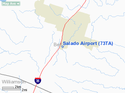
Location & QuickFacts
| FAA Information Effective: | 2008-09-25 |
| Airport Identifier: | 73TA |
| Airport Status: | Operational |
| Longitude/Latitude: | 097-32-23.0320W/30-55-14.6630N
-97.539731/30.920740 (Estimated) |
| Elevation: | 670 ft / 204.22 m (Estimated) |
| Land: | 60 acres |
| From nearest city: | 2 nautical miles S of Salado, TX |
| Location: | Bell County, TX |
| Magnetic Variation: | 07E (1985) |
Owner & Manager
| Ownership: | Privately owned |
| Owner: | Salado Arpt Corp. |
| Address: | 201 San Juan
Salado, TX 76571 |
| Phone number: | 817-947-5132 |
| Manager: | Glenn Hodge |
| Address: | 201 San Juan
Salado, TX 76571 |
| Phone number: | 817-947-5132 |
Airport Operations and Facilities
| Airport Use: | Private |
| Wind indicator: | Yes |
| Segmented Circle: | No |
| Control Tower: | No |
| Landing fee charge: | No |
| Sectional chart: | San Antonio |
| Region: | ASW - Southwest |
| Boundary ARTCC: | ZHU - Houston |
| Tie-in FSS: | SJT - San Angelo |
| FSS on Airport: | No |
| FSS Toll Free: | 1-800-WX-BRIEF |
Airport Services
| Airframe Repair: | NONE |
| Power Plant Repair: | NONE |
| Bottled Oxygen: | NONE |
| Bulk Oxygen: | NONE |
Runway Information
Runway 01/19
| Dimension: | 3190 x 100 ft / 972.3 x 30.5 m |
| Surface: | TURF-DIRT, Fair Condition |
| |
Runway 01 |
Runway 19 |
| Traffic Pattern: | Left | Left |
| Markings: | Nonstandard,
01/19 WHITE AUTO TIRES & RED & AMBER REFLECTORS MARK THR; RWY EDGES MRKD BY RED AND AMBER REFECTORS. | Nonstandard, |
| Obstruction: | 4 ft post, 55 ft right of centerline | 4 ft post, 0.0 ft from runway, 55 ft right of centerline |
|
Radio Navigation Aids
| ID |
Type |
Name |
Ch |
Freq |
Var |
Dist |
| IL | NDB | Iresh | | 278.00 | 07E | 10.7 nm |
| HLR | NDB | Hood | | 347.00 | 07E | 15.3 nm |
| GUO | NDB | Georgetown | | 332.00 | 06E | 15.9 nm |
| GR | NDB | Starn | | 323.00 | 07E | 22.9 nm |
| BMQ | NDB | Burnet | | 341.00 | 07E | 37.6 nm |
| ROB | NDB | Robinson | | 400.00 | 07E | 42.6 nm |
| MFS | NDB | Horseshoe Bay Resort | | 403.00 | 07E | 48.6 nm |
| GRK | VOR/DME | Gray | 055X | 111.80 | 07E | 15.6 nm |
| TPL | VOR/DME | Temple | 041X | 110.40 | 09E | 18.3 nm |
| CWK | VORTAC | Centex | 075X | 112.80 | 06E | 32.6 nm |
| LZZ | VORTAC | Lampasas | 072X | 112.50 | 08E | 34.9 nm |
| ACT | VORTAC | Waco | 100X | 115.30 | 09E | 46.7 nm |
Remarks
- UNUSBL DURG AND 24 HOURS AFTER HEAVY RAIN.
- RWY ROUGH.
- (E110-2) RWY ROUGH.
- VFR ONLY
Images and information placed above are from
http://www.airport-data.com/airport/73TA/
We thank them for the data!
| General Info
|
| Country |
United States
|
| State |
TEXAS
|
| FAA ID |
73TA
|
| Latitude |
30-55-14.663N
|
| Longitude |
097-32-23.032W
|
| Elevation |
670 feet
|
| Near City |
SALADO
|
We don't guarantee the information is fresh and accurate. The data may
be wrong or outdated.
For more up-to-date information please refer to other sources.
|
|


