 |
|
Coordinates: 29°45′42″N 094°50′47″W / 29.76167°N 94.84639°W / 29.76167; -94.84639
| RWJ Airpark |
| IATA: none – ICAO: none – FAA LID: 54T |
| Summary |
| Airport type |
Public |
| Owner |
R. W. Johnson Const Co. Inc. |
| Serves |
Beach City, Texas |
| Elevation AMSL |
30 ft / 9 m |
| Website |
www.rwjairpark.com |
| Runways |
| Direction |
Length |
Surface |
| ft |
m |
| 8/26 |
5,035 |
1,535 |
Asphalt |
| 14/32 |
3,500 |
1,067 |
Turf |
| Statistics (2004) |
| Aircraft operations |
9,300 |
| Based aircraft |
45 |
| Source: airport web site and FAA |
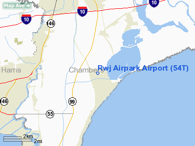
RWJ Airpark (FAA LID: 54T) is a public-use airport located in Beach City, Chambers County, Texas, United States, seven miles (11 km) east of the central business district of Baytown. It is privately-owned by the R. W. Johnson Const. Co. Inc.
Facilities and aircraft
RWJ Airpark covers an area of 55 acres (22 ha) which contains two runways: 8/26 with a 5,035 x 40 ft (1,535 x 12 m) asphalt pavement and 14/32 with a 3,500 x 100 ft (1,067 x 30 m) turf surface.
For the 12-month period ending July 12, 2004, the airport had 9,300 general aviation aircraft operations, an average of 25 per day. At that time there were 45 aircraft based at the airport: 67% single-engine, 7% multi-engine and 27% ultralight.
The above content comes from Wikipedia and is published under free licenses – click here to read more.
Location & QuickFacts
| FAA Information Effective: | 2008-09-25 |
| Airport Identifier: | 54T |
| Airport Status: | Operational |
| Longitude/Latitude: | 094-50-47.4000W/29-45-42.0000N
-94.846500/29.761667 (Estimated) |
| Elevation: | 30 ft / 9.14 m (Surveyed) |
| Land: | 55 acres |
| From nearest city: | 7 nautical miles E of Baytown, TX |
| Location: | Chambers County, TX |
| Magnetic Variation: | 05E (1985) |
Owner & Manager
| Ownership: | Privately owned |
| Owner: | R. W. Johnson Const Co Inc |
| Address: | 15111 Lakeview Drive
Baytown, TX 77520 |
| Phone number: | 281-383-2461 |
| Manager: | Buddy Johnson |
| Address: | 15111 Lakeview Drive
Baytown, TX 77520 |
| Phone number: | 281-383-2320 |
Airport Operations and Facilities
| Airport Use: | Open to public |
| Wind indicator: | Yes |
| Segmented Circle: | No |
| Control Tower: | No |
| Lighting Schedule: | DUSK-DAWN
FOR LIRL AFT 2200 ACTVT - CTAF. |
| Beacon Color: | Clear-Green (lighted land airport) |
| Landing fee charge: | No |
| Sectional chart: | Houston |
| Region: | ASW - Southwest |
| Boundary ARTCC: | ZHU - Houston |
| Tie-in FSS: | CXO - Montgomery County |
| FSS on Airport: | No |
| FSS Toll Free: | 1-800-WX-BRIEF
FOR FP FILING CALL CXO FSS 1-800-833-5602 |
| NOTAMs Facility: | CXO (NOTAM-d service avaliable) |
Airport Communications
| CTAF: | 122.700 |
| Unicom: | 122.700 |
Airport Services
| Fuel available: | 100LLA |
| Airframe Repair: | MINOR |
| Power Plant Repair: | MINOR |
Runway Information
Runway 08/26
| Dimension: | 5035 x 40 ft / 1534.7 x 12.2 m
EAST 1100 FT 60 FT WIDE. |
| Surface: | ASPH, Good Condition |
| Weight Limit: | Single wheel: 6000 lbs. |
| Edge Lights: | Low |
| |
Runway 08 |
Runway 26 |
| Longitude: | 094-51-15.9970W | 094-50-18.8840W |
| Latitude: | 29-45-41.5370N | 29-45-42.3840N |
| Elevation: | 30.00 ft | 27.00 ft |
| Alignment: | 89 | 127 |
| Traffic Pattern: | Left | Left |
| Markings: | Nonstandard, Good Condition
08/26 NUMBERS 40 FT TALL. | Nonstandard, Good Condition |
| Displaced threshold: | 0.00 ft | 939.00 ft |
| Obstruction: | 32 ft plines, 460.0 ft from runway, 8:1 slope to clear | 30 ft pole, 235.0 ft from runway, 90 ft left of centerline, 1:1 slope to clear
APCH SLOPE 0:1 TO DSPLCD THLD; +4 FT FENCE 92 FT R CNTRLN & +15 FT ROAD 60 FT R CNTRLN AT DSPLCD THLD.
+15 FT RD 0-200 FT FM THLD 60 FT R CNTRLN; +4 FT FENCE 0-200 FT FM THLD 92 FT R CNTRLN. 50 FT TREES 110 FT FM THLD 135 FT LT CNTRLN. |
|
Runway 14/32
| Dimension: | 3500 x 100 ft / 1066.8 x 30.5 m
EAST 1100 FT 60 FT WIDE. |
| Surface: | TURF, Good Condition |
| Weight Limit: | Single wheel: 4000 lbs. |
| |
Runway 14 |
Runway 32 |
| Longitude: | 094-51-10.7240W | 094-50-49.2230W |
| Latitude: | 29-45-58.8060N | 29-45-29.3070N |
| Elevation: | 33.00 ft | 28.00 ft |
| Traffic Pattern: | Left | Left |
| Obstruction: | 15 ft road, 50 ft left of centerline | 40 ft trees, 0.0 ft from runway, 100 ft left of centerline |
|
Radio Navigation Aids
| ID |
Type |
Name |
Ch |
Freq |
Var |
Dist |
| CBC | NDB | Anahuac | | 413.00 | 05E | 9.6 nm |
| JPA | NDB | Sanjac | | 347.00 | 05E | 12.9 nm |
| BVP | NDB | Nixin | | 326.00 | 05E | 23.7 nm |
| GLS | NDB | Galveston | | 206.00 | 08E | 26.1 nm |
| SYG | NDB | Sandy Point | | 402.00 | 05E | 36.0 nm |
| GDE | NDB | Goodhue | | 368.00 | 07E | 38.3 nm |
| EYQ | NDB | Weiser | | 286.00 | 06E | 42.7 nm |
| SGR | NDB | Hull | | 388.00 | 05E | 43.0 nm |
| DWH | NDB | David Hooks | | 521.00 | 05E | 43.4 nm |
| LYD | NDB | Lakeside | | 249.00 | 05E | 43.5 nm |
| HRD | NDB | Hardin County | | 524.00 | 04E | 46.1 nm |
| EFD | TACAN | Ellington | 031X | | 05E | 18.8 nm |
| MHF | VOR/DME | Trinity | 083X | 113.60 | 07E | 13.9 nm |
| HUB | VOR/DME | Hobby | 118X | 117.10 | 05E | 23.3 nm |
| SBI | VOR/DME | Sabine Pass | 101X | 115.40 | 07E | 42.4 nm |
| BPT | VOR/DME | Beaumont | 092X | 114.50 | 07E | 44.7 nm |
| DAS | VORTAC | Daisetta | 116X | 116.90 | 05E | 27.8 nm |
| IAH | VORTAC | Humble | 113X | 116.60 | 05E | 28.5 nm |
| VUH | VORTAC | Scholes | 077X | 113.00 | 06E | 29.6 nm |
| HOU | VOT | Houston Wm P Hobby | | 108.40 | | 23.6 nm |
Remarks
- TWY TOO NARROW FOR SOME ACFT USE EXTREME CARE. TWIN ENGINE ACFT PROHIBIT ON TWY.
Images and information placed above are from
http://www.airport-data.com/airport/54T/
We thank them for the data!
| General Info
|
| Country |
United States
|
| State |
TEXAS
|
| FAA ID |
54T
|
| Latitude |
29-45-42.000N
|
| Longitude |
094-50-47.400W
|
| Elevation |
30 feet
|
| Near City |
BAYTOWN
|
We don't guarantee the information is fresh and accurate. The data may
be wrong or outdated.
For more up-to-date information please refer to other sources.
|
|


