 |
|
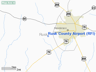
Location & QuickFacts
| FAA Information Effective: | 2008-09-25 |
| Airport Identifier: | RFI |
| Airport Status: | Operational |
| Longitude/Latitude: | 094-51-06.2000W/32-08-30.2000N
-94.851722/32.141722 (Estimated) |
| Elevation: | 442 ft / 134.72 m (Surveyed) |
| Land: | 521 acres |
| From nearest city: | 3 nautical miles W of Henderson, TX |
| Location: | Rusk County, TX |
| Magnetic Variation: | 06E (1980) |
Owner & Manager
| Ownership: | Publicly owned |
| Owner: | Rusk County |
| Address: | Rusk Co Courthouse
Henderson, TX 75652 |
| Phone number: | 903-657-0302 |
| Manager: | Jim Patterson |
| Address: | 3500 County Road 416a
Henderson, TX 75652 |
| Phone number: | 903-657-7081 |
Airport Operations and Facilities
| Airport Use: | Open to public |
| Wind indicator: | Yes |
| Segmented Circle: | Yes |
| Control Tower: | No |
| Lighting Schedule: | DUSK-DAWN |
| Beacon Color: | Clear-Green (lighted land airport) |
| Landing fee charge: | No |
| Sectional chart: | Memphis |
| Region: | ASW - Southwest |
| Boundary ARTCC: | ZFW - Fort Worth |
| Tie-in FSS: | FTW - Fort Worth |
| FSS on Airport: | No |
| FSS Phone: | 817-541-3474 |
| FSS Toll Free: | 1-800-WX-BRIEF |
| NOTAMs Facility: | FTW (NOTAM-d service avaliable) |
| Federal Agreements: | NGY3 |
Airport Communications
| CTAF: | 122.800 |
| Unicom: | 122.800 |
Airport Services
| Fuel available: | 100LL
FUEL SELF SERVICE; CREDIT CARD ONLY BTN 1830-0630. |
| Bottled Oxygen: | NONE |
| Bulk Oxygen: | NONE |
Runway Information
Runway 12/30
| Dimension: | 3002 x 75 ft / 915.0 x 22.9 m |
| Surface: | ASPH, Good Condition |
| Weight Limit: | Single wheel: 22000 lbs. |
| |
Runway 12 |
Runway 30 |
| Longitude: | 094-51-19.8960W | 094-50-51.6510W |
| Latitude: | 32-08-36.0830N | 32-08-18.6300N |
| Elevation: | 434.00 ft | 437.00 ft |
| Alignment: | 126 | 127 |
| Traffic Pattern: | Left | Left |
| Markings: | Basic, Good Condition | Basic, Good Condition |
| Obstruction: | 18 ft trees, 575.0 ft from runway, 20:1 slope to clear | 80 ft tree, 1320.0 ft from runway, 200 ft right of centerline, 14:1 slope to clear |
|
Runway 16/34
| Dimension: | 4004 x 75 ft / 1220.4 x 22.9 m |
| Surface: | ASPH, Good Condition |
| Weight Limit: | Single wheel: 22000 lbs. |
| Edge Lights: | Non-standard lighting system
NSTD MIRL DUE TO INCORRECT SPACING. |
| |
Runway 16 |
Runway 34 |
| Longitude: | 094-51-10.6020W | 094-51-02.5080W |
| Latitude: | 32-08-51.8400N | 32-08-12.8200N |
| Elevation: | 435.00 ft | 440.00 ft |
| Alignment: | 127 | 127 |
| Traffic Pattern: | Left | Left |
| Markings: | Non-precision instrument, Good Condition | Non-precision instrument, Good Condition |
| Crossing Height: | 24.00 ft | 30.00 ft |
| VASI: | 2-box on left side | 4-light PAPI on left side |
| Visual Glide Angle: | 4.00° | 3.00° |
| Obstruction: | 80 ft trees, 1200.0 ft from runway, 180 ft right of centerline, 12:1 slope to clear | 24 ft trees, 200.0 ft from runway, 200 ft right of centerline
10-24 FT TREES FM THLD TO 200 FT; 220 FT RIGHT. |
|
Radio Navigation Aids
| ID |
Type |
Name |
Ch |
Freq |
Var |
Dist |
| HNO | NDB | Henderson | | 371.00 | 06E | 2.8 nm |
| JSO | NDB | Cherokee County | | 263.00 | 05E | 24.7 nm |
| RPF | NDB | Carthage | | 332.00 | 04E | 28.4 nm |
| ABG | NDB | Ambassador | | 404.00 | 07E | 29.8 nm |
| GXD | NDB | Nacogdoches | | 391.00 | 05E | 30.6 nm |
| TY | NDB | Tyler | | 320.00 | 06E | 35.5 nm |
| OC | NDB | Nados | | 253.00 | 05E | 40.0 nm |
| CZJ | NDB | Amason | | 341.00 | 04E | 40.1 nm |
| LST | NDB | Lone Star | | 305.00 | 05E | 47.6 nm |
| PSN | NDB | Palestine | | 375.00 | 04E | 48.5 nm |
| AHX | NDB | Athens | | 269.00 | 06E | 49.8 nm |
| TYR | VOR/DME | Tyler | 089X | 114.20 | 06E | 30.9 nm |
| FZT | VOR/DME | Frankston | 051X | 111.40 | 06E | 34.8 nm |
| GGG | VORTAC | Gregg County | 070X | 112.30 | 07E | 17.3 nm |
Images and information placed above are from
http://www.airport-data.com/airport/RFI/
We thank them for the data!
|
|


