 |
|
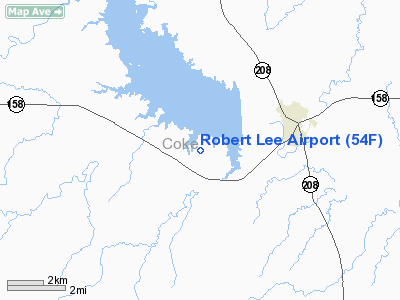
Location & QuickFacts
| FAA Information Effective: | 2008-09-25 |
| Airport Identifier: | 54F |
| Airport Status: | Operational |
| Longitude/Latitude: | 100-32-25.3610W/31-52-54.5160N
-100.540378/31.881810 (Estimated) |
| Elevation: | 1922 ft / 585.83 m (Estimated) |
| Land: | 57 acres |
| From nearest city: | 3 nautical miles SW of Robert Lee, TX |
| Location: | Coke County, TX |
| Magnetic Variation: | 08E (1985) |
Owner & Manager
| Ownership: | Publicly owned |
| Owner: | County Of Coke |
| Address: | 13 East 7th
Robert Lee, TX 76945 |
| Phone number: | 325-453-2641 |
| Manager: | Roy Blair
COUNTY JUDGE. |
| Address: | County Courthouse, 13 East 7th
Robert Lee, TX 76945 |
| Phone number: | 325-453-2641 |
Airport Operations and Facilities
| Airport Use: | Open to public |
| Wind indicator: | Yes |
| Segmented Circle: | Yes |
| Control Tower: | No |
| Lighting Schedule: | DUSK-DAWN
ACTVT MIRL RY 17/35 - 122.8. |
| Beacon Color: | Clear-Green (lighted land airport)
ROTG BCN OTS INDEFLY. |
| Landing fee charge: | No |
| Sectional chart: | San Antonio |
| Region: | ASW - Southwest |
| Boundary ARTCC: | ZFW - Fort Worth |
| Tie-in FSS: | SJT - San Angelo |
| FSS on Airport: | No |
| FSS Toll Free: | 1-800-WX-BRIEF |
| NOTAMs Facility: | SJT (NOTAM-d service avaliable) |
Airport Communications
Airport Services
Runway Information
Runway 17/35
| Dimension: | 4450 x 50 ft / 1356.4 x 15.2 m |
| Surface: | ASPH, Fair Condition |
| Weight Limit: | Single wheel: 12500 lbs. |
| Edge Lights: | Medium
PCL OTS INDEFLY. |
| |
Runway 17 |
Runway 35 |
| Traffic Pattern: | Left | Left |
| Markings: | Basic, Fair Condition | Basic, Fair Condition |
| Obstruction: | 10 ft brush, 279.0 ft from runway, 7:1 slope to clear | 13 ft tree, 330.0 ft from runway, 10:1 slope to clear |
|
Radio Navigation Aids
| ID |
Type |
Name |
Ch |
Freq |
Var |
Dist |
| IEW | NDB | Winters | | 396.00 | 08E | 28.4 nm |
| UBC | NDB | Ballinger | | 239.00 | 08E | 31.3 nm |
| SWW | NDB | Sweetwater | | 275.00 | 08E | 35.1 nm |
| DYS | TACAN | Dyess | 063X | | 08E | 47.4 nm |
| TQA | VOR/DME | Tuscola | 053X | 111.60 | 10E | 42.6 nm |
| SJT | VORTAC | San Angelo | 098X | 115.10 | 10E | 30.8 nm |
| ABI | VORTAC | Abilene | 084X | 113.70 | 10E | 49.8 nm |
Remarks
- LOOSE GRAVEL ON RY; TWY & APRON.
Images and information placed above are from
http://www.airport-data.com/airport/54F/
We thank them for the data!
| General Info
|
| Country |
United States
|
| State |
TEXAS
|
| FAA ID |
54F
|
| Latitude |
31-52-54.516N
|
| Longitude |
100-32-25.361W
|
| Elevation |
1922 feet
|
| Near City |
ROBERT LEE
|
We don't guarantee the information is fresh and accurate. The data may
be wrong or outdated.
For more up-to-date information please refer to other sources.
|
|


