 |
|
Killeen-Fort Hood Regional Airport
Robert Gray Army Airfield |
 |
| IATA: GRK – ICAO: KGRK |
| Summary |
| Airport type |
Military/Public |
| Operator |
United States Army ATCA-ASO |
| Location |
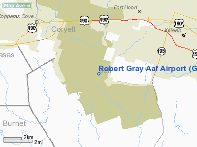
Bell County, near Killeen, Texas |
| Elevation AMSL |
1,015 ft / 309 m |
| Coordinates |
31°04′02″N 97°49′44″W / 31.06722°N 97.82889°W / 31.06722; -97.82889Coordinates: 31°04′02″N 97°49′44″W / 31.06722°N 97.82889°W / 31.06722; -97.82889 |
| Runways |
| Direction |
Length |
Surface |
| ft |
m |
| 15/33 |
10,000 |
3,048 |
PEM |
Killeen-Fort Hood Regional Airport (IATA: GRK, ICAO: KGRK) is a small military/commercial joint-use airport also known by its military designation as Robert Gray Army Airfield. The airport is based inside the south end of the Fort Hood Military Reservation (known as West Fort Hood), a few miles southwest of Killeen in unincorporated Bell County, Texas. The airport has a single runway. The commercial side replaced the old Killeen Municipal Airport (now Skylark Field), which was unable to expand. Airlines
| Airlines |
Destinations |
| American Eagle |
Dallas/Fort Worth |
| American Eagle operated by Executive Airlines |
Dallas/Fort Worth |
| Continental Connection operated by Colgan Air |
Houston-Intercontinental |
| Delta Connection operated by Atlantic Southeast Airlines |
Atlanta |
The above content comes from Wikipedia and is published under free licenses – click here to read more.
Location & QuickFacts
| FAA Information Effective: | 2008-09-25 |
| Airport Identifier: | GRK |
| Airport Status: | Operational |
| Longitude/Latitude: | 097-49-44.1000W/31-04-02.1000N
-97.828917/31.067250 (Estimated) |
| Elevation: | 1015 ft / 309.37 m (Surveyed) |
| Land: | 0 acres |
| From nearest city: | 6 nautical miles SW of Fort Hood/killeen, TX |
| Location: | Bell County, TX |
| Magnetic Variation: | 07E (1990) |
Owner & Manager
| Ownership: | Army owned |
| Owner: | Us Army Atca-aso
CONTACT RON GERNER, DIRECTOR OF AVIATION FOR MILITARY. |
| Address: | Cameron Station
Alexandria, VA 22314 |
| Phone number: | 254-288-9200 |
| Manager: | John Sutton
CIVILIAN ARPT MANAGER. |
| Address: | 8101 Clear Creek Rd, Box C
Killeen, TX 76549 |
| Phone number: | 254-288-1432 |
Airport Operations and Facilities
| Airport Use: | Open to public |
| Wind indicator: | Yes |
| Segmented Circle: | No |
| Control Tower: | Yes |
| Lighting Schedule: | DUSK-DAWN |
| Beacon Color: | Split-Clear-Green (lighted military airport) |
| Sectional chart: | San Antonio |
| Region: | ASW - Southwest |
| Boundary ARTCC: | ZHU - Houston |
| Responsible ARTCC: | ZFW - Fort Worth |
| Tie-in FSS: | SJT - San Angelo |
| FSS on Airport: | No |
| FSS Toll Free: | 1-800-WX-BRIEF |
| NOTAMs Facility: | GRK (NOTAM-d service avaliable) |
| Certification type/date: | I E S 08/1990 |
| Federal Agreements: | NGY |
Airport Communications
Airport Services
| Fuel available: | A
JET A AVBL 0600-2000. |
Runway Information
Runway 15/33
| Dimension: | 10000 x 200 ft / 3048.0 x 61.0 m |
| Surface: | PEM, |
| Pavement Class: | 57 /R/B/W/T |
| Weight Limit: | Dual wheel: 135000 lbs.
Dual tandem wheel: 345000 lbs. |
| Edge Lights: | High |
| |
Runway 15 |
Runway 33 |
| Longitude: | 097-50-06.2815W | 097-49-22.0050W |
| Latitude: | 31-04-47.7210N | 31-03-16.3957N |
| Elevation: | 1015.00 ft | 972.00 ft |
| Alignment: | 127 | 127 |
| ILS Type: | ILS
| ILS/DME
|
| Traffic Pattern: | Left | Left |
| Markings: | Precision instrument, Good Condition | Precision instrument, Good Condition |
| Arresting: | | BAK12 |
| Crossing Height: | 71.00 ft | 52.00 ft |
| Displaced threshold: | 0.00 ft | 194.00 ft |
| VASI: | 4-light PAPI on left side | 4-light PAPI on left side |
| Visual Glide Angle: | 3.00° | 2.77° |
| RVR Equipment: | touchdown | |
| Approach lights: | SALS | SALS |
|
Radio Navigation Aids
| ID |
Type |
Name |
Ch |
Freq |
Var |
Dist |
| GR | NDB | Starn | | 323.00 | 07E | 6.6 nm |
| IL | NDB | Iresh | | 278.00 | 07E | 6.7 nm |
| HLR | NDB | Hood | | 347.00 | 07E | 7.1 nm |
| GUO | NDB | Georgetown | | 332.00 | 06E | 24.3 nm |
| BMQ | NDB | Burnet | | 341.00 | 07E | 28.8 nm |
| MNZ | NDB | Hamilton | | 251.00 | 07E | 37.0 nm |
| MFS | NDB | Horseshoe Bay Resort | | 403.00 | 07E | 42.6 nm |
| ROB | NDB | Robinson | | 400.00 | 07E | 47.0 nm |
| GRK | VOR/DME | Gray | 055X | 111.80 | 07E | 2.2 nm |
| TPL | VOR/DME | Temple | 041X | 110.40 | 09E | 22.5 nm |
| LZZ | VORTAC | Lampasas | 072X | 112.50 | 08E | 17.6 nm |
| CWK | VORTAC | Centex | 075X | 112.80 | 06E | 44.2 nm |
| ACT | VORTAC | Waco | 100X | 115.30 | 09E | 45.9 nm |
Remarks
- TFC PAT: TFC PAT ALT LEFT AND RGT. R/W 1800', F/W 2500', PURE JET/OVERHEAD 3000'.
- MISC: CLSD CIRCUIT TV OPR.
- MISC: ALL INBD VIP ACFT CTC PTD 20 MIN PRIOR TO LDG. BASE OPS FAX DSN 738-1930, C254-288-1930.
- PPR ALL CIVIL ACFT CTC AMGR AT 254-501-8704, OR OPS 254-501-8750.
- RSTD: PPR RQR DSN 738-9200/9209, C254-288-9200/9209. NO OFFL TRANS AVBL.
- MISC: TWY B (FROM TWY E TO APCH END RWY 33) NOT AUTH FOR DOD ACFT THAT RQR CLASS B RWY.
- MISC: TWY B (FROM TWY C TO TWY E) RSTD TO ACFT WITH WINGSPAN 200' OR LESS.
- MISC: PAR NOT AVBL (EXC EMERGENCY) FROM 0500-1300Z++.
- MISC: GUARD APVL FOR RAMP ACCESS.
- CAUTION: EXTV COPTER OPR VCNTY FORT HOOD, SOME WO CONSPICUOUS MRK AND BLEND WITH TERRAIN.
- CSTMS/AG/IMG: CSTMS AVBL 24 HR PN RQR. DUR NML DUTY HR CTC PMO CSTMS DSN 737-1942, C254-287-1942, OT CTC BASE OPS DSN 738-9200, C254-288-9200.
- MISC: CTC GRAY TWR FOR LDG/DEP PAD 24. LTD PRK.
- MISC: WX VIS OBST RSTD S THRU NW.
- CAUTION: DEER VCNTY RWY.
- BEARING STRENGTH RWY 15/33: ST175 SBTT593 TRT840 TRT585.
- JASU: 1(AM32A-60) 4(A/M32A-86).
- FUEL: J8 PPR ONLY.
Images and information placed above are from
http://www.airport-data.com/airport/GRK/
We thank them for the data!
| General Info
|
| Country |
United States
|
| State |
TEXAS
|
| FAA ID |
GRK
|
| Latitude |
31-04-02.062N
|
| Longitude |
097-49-44.139W
|
| Elevation |
1015 feet
|
| Near City |
FORT HOOD/KILLEEN
|
We don't guarantee the information is fresh and accurate. The data may
be wrong or outdated.
For more up-to-date information please refer to other sources.
|
|


