 |
|
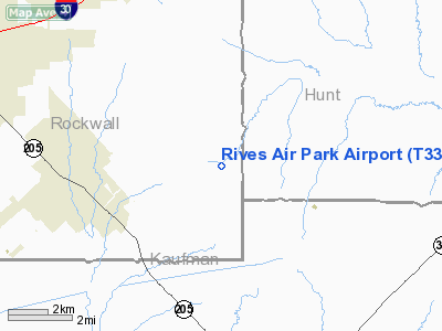
| Rives Air Park |
| IATA: none – ICAO: none – FAA LID: T33 |
| Summary |
| Airport type |
Public |
| Location |
Royse City, Texas |
| Elevation AMSL |
555 ft / 169 m |
| Coordinates |
32°51′25″N 096°18′30″W / 32.85694°N 96.30833°W / 32.85694; -96.30833Coordinates: 32°51′25″N 096°18′30″W / 32.85694°N 96.30833°W / 32.85694; -96.30833 |
| Runways |
| Direction |
Length |
Surface |
| ft |
m |
| 4/22 |
2,800 |
853 |
Asphalt |
Rives Air Park (FAA LID: T33) is a public airport located nine miles (14.5 km) south of the central business district (CBD) of Royse City, in Rockwall County, Texas, USA.
The airport is used solely for general aviation purposes.
Facilities
Rives Air Park has one runway:
- Runway 4/22: 2,800 x 40 ft. (853 x 12 m), Surface: Asphalt
The above content comes from Wikipedia and is published under free licenses – click here to read more.
Location & QuickFacts
| FAA Information Effective: | 2008-09-25 |
| Airport Identifier: | T33 |
| Airport Status: | Operational |
| Longitude/Latitude: | 096-18-29.9300W/32-51-25.4500N
-96.308314/32.857069 (Estimated) |
| Elevation: | 555 ft / 169.16 m (Estimated) |
| Land: | 43 acres |
| From nearest city: | 9 nautical miles S of Royse City, TX |
| Location: | Rockwall County, TX |
| Magnetic Variation: | 06E (1995) |
Owner & Manager
| Ownership: | Privately owned |
| Owner: | Marion T Rives |
| Address: | 1540 Fm 548
Terrell, TX 75160 |
| Phone number: | 972-279-2235 |
| Manager: | Marion T Rives |
| Address: | 1550 S Fm 548
Terrell, TX 75160 |
| Phone number: | 972-563-4303 |
Airport Operations and Facilities
| Airport Use: | Open to public |
| Wind indicator: | Yes |
| Segmented Circle: | Yes |
| Control Tower: | No |
| Sectional chart: | Dallas-ft Worth |
| Region: | ASW - Southwest |
| Boundary ARTCC: | ZFW - Fort Worth |
| Tie-in FSS: | FTW - Fort Worth |
| FSS on Airport: | No |
| FSS Phone: | 817-541-3474 |
| FSS Toll Free: | 1-800-WX-BRIEF |
| NOTAMs Facility: | FTW (NOTAM-d service avaliable) |
Airport Communications
| CTAF: | 122.700 |
| Unicom: | 122.700 |
Airport Services
| Airframe Repair: | MINOR |
| Power Plant Repair: | MINOR |
Runway Information
Runway 04/22
| Dimension: | 2800 x 40 ft / 853.4 x 12.2 m |
| Surface: | ASPH, Poor Condition
RY OVERGROWN WITH 2-3 FT WEEDS & GRASS. |
| |
Runway 04 |
Runway 22 |
| Traffic Pattern: | Left | Right |
| Markings: | Nonstandard, Good Condition
RY 04 /22 NSTD NRS; LINES FORMING NRS ONLY 1 FT WIDE. PAINT FADED. | Nonstandard, Good Condition |
| Obstruction: | 10 ft trees, 200.0 ft from runway
+10 FT TREES 70 FT ON EXTDD CNTRLN, +4 FT FENCE 10 FT ON CNTRLN. | 40 ft trees, 200.0 ft from runway
+40 FT TREES 125 FT ON EXTDD CNTRLN. |
|
Radio Navigation Aids
| ID |
Type |
Name |
Ch |
Freq |
Var |
Dist |
| AVZ | NDB | Travis | | 260.00 | 06E | 6.5 nm |
| MII | NDB | Caddo Mills | | 316.00 | 06E | 11.4 nm |
| PQF | NDB | Mesquite | | 248.00 | 06E | 11.5 nm |
| SYW | NDB | Cash | | 428.00 | 05E | 14.3 nm |
| JUG | NDB | Jecca | | 388.00 | 06E | 16.0 nm |
| LNC | NDB | Lancaster | | 239.00 | 06E | 26.8 nm |
| RBD | NDB | Redbird | | 287.00 | 06E | 30.4 nm |
| XQH | NDB | Cedar Hill | | 353.00 | 08E | 37.4 nm |
| HJM | NDB | Rayburn | | 415.00 | 06E | 46.0 nm |
| CGQ | NDB | Powell | | 344.00 | 06E | 48.1 nm |
| AHX | NDB | Athens | | 269.00 | 06E | 48.4 nm |
| MJF | TACAN | Arvilla | 033X | | 05E | 17.7 nm |
| CVE | VOR/DME | Cowboy | 109X | 116.20 | 06E | 30.1 nm |
| TTT | VOR/DME | Maverick | 078X | 113.10 | 06E | 37.0 nm |
| SLR | VOR/DME | Sulphur Springs | 027X | 109.00 | 08E | 43.7 nm |
| UIM | VOR/DME | Quitman | 087X | 114.00 | 08E | 47.6 nm |
| CQY | VORTAC | Cedar Creek | 095X | 114.80 | 06E | 40.6 nm |
| BYP | VORTAC | Bonham | 093X | 114.60 | 06E | 41.1 nm |
| FUZ | VORTAC | Ranger | 104X | 115.70 | 06E | 44.0 nm |
| DAL | VOT | Dallas Love Field | | 113.30 | | 27.4 nm |
Remarks
- NO LINE OF SIGHT.
- AIRPORT ACCESS GATE LOCKED
Images and information placed above are from
http://www.airport-data.com/airport/T33/
We thank them for the data!
| General Info
|
| Country |
United States
|
| State |
TEXAS
|
| FAA ID |
T33
|
| Latitude |
32-51-25.450N
|
| Longitude |
096-18-29.930W
|
| Elevation |
555 feet
|
| Near City |
ROYSE CITY
|
We don't guarantee the information is fresh and accurate. The data may
be wrong or outdated.
For more up-to-date information please refer to other sources.
|
|


