 |
|
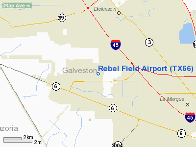
Location & QuickFacts
| FAA Information Effective: | 2008-09-25 |
| Airport Identifier: | TX66 |
| Airport Status: | Operational |
| Longitude/Latitude: | 095-04-42.7420W/29-23-55.8430N
-95.078539/29.398845 (Estimated) |
| Elevation: | 28 ft / 8.53 m (Estimated) |
| Land: | 0 acres |
| From nearest city: | 2 nautical miles NN of Alta Loma, TX |
| Location: | Galveston County, TX |
| Magnetic Variation: | 06E (1985) |
Owner & Manager
| Ownership: | Privately owned |
| Owner: | Santa Fe Flying Club Inc |
| Address: | Po Box 1058
Santa Fe, TX 77510 |
| Phone number: | 409-925-4305 |
| Manager: | Sonny Johnson |
| Address: | Po Box 1058
Santa Fe, TX 77510 |
| Phone number: | 409-925-4305 |
Airport Operations and Facilities
| Airport Use: | Private |
| Wind indicator: | Yes |
| Segmented Circle: | No |
| Control Tower: | No |
| Landing fee charge: | No |
| Sectional chart: | Houston |
| Region: | ASW - Southwest |
| Boundary ARTCC: | ZHU - Houston |
| Tie-in FSS: | CXO - Montgomery County |
| FSS on Airport: | No |
| FSS Toll Free: | 1-800-WX-BRIEF
FOR FP FILING CALL CXO FSS 1-800-833-5602. |
Airport Communications
Airport Services
| Airframe Repair: | MINOR |
| Power Plant Repair: | MINOR |
Runway Information
Runway 17/35
| Dimension: | 1900 x 80 ft / 579.1 x 24.4 m |
| Surface: | TURF, |
| |
Runway 17 |
Runway 35 |
| Traffic Pattern: | Left | Left |
| Obstruction: | 70 ft pline, 200.0 ft from runway | 4 ft fence, 0.0 ft from runway |
|
Radio Navigation Aids
| ID |
Type |
Name |
Ch |
Freq |
Var |
Dist |
| JPA | NDB | Sanjac | | 347.00 | 05E | 16.2 nm |
| GLS | NDB | Galveston | | 206.00 | 08E | 17.3 nm |
| SYG | NDB | Sandy Point | | 402.00 | 05E | 21.3 nm |
| CBC | NDB | Anahuac | | 413.00 | 05E | 31.3 nm |
| SGR | NDB | Hull | | 388.00 | 05E | 33.3 nm |
| BVP | NDB | Nixin | | 326.00 | 05E | 36.4 nm |
| LYD | NDB | Lakeside | | 249.00 | 05E | 40.1 nm |
| EYQ | NDB | Weiser | | 286.00 | 06E | 43.6 nm |
| BYY | NDB | Bay City | | 344.00 | 06E | 48.3 nm |
| EFD | TACAN | Ellington | 031X | | 05E | 13.2 nm |
| HUB | VOR/DME | Hobby | 118X | 117.10 | 05E | 18.6 nm |
| MHF | VOR/DME | Trinity | 083X | 113.60 | 07E | 19.5 nm |
| VUH | VORTAC | Scholes | 077X | 113.00 | 06E | 13.5 nm |
| IAH | VORTAC | Humble | 113X | 116.60 | 05E | 36.3 nm |
| HOU | VOT | Houston Wm P Hobby | | 108.40 | | 18.1 nm |
Remarks
- PRVDD TO PROVIDE A 20:1 SLOPE OVER PLINES & OTHER OBSTRUCTIONS IN APCH AREAS & RWY THRS ARE DSPLCD & MARKED.
Images and information placed above are from
http://www.airport-data.com/airport/TX66/
We thank them for the data!
| General Info
|
| Country |
United States
|
| State |
TEXAS
|
| FAA ID |
TX66
|
| Latitude |
29-23-55.843N
|
| Longitude |
095-04-42.742W
|
| Elevation |
28 feet
|
| Near City |
ALTA LOMA
|
We don't guarantee the information is fresh and accurate. The data may
be wrong or outdated.
For more up-to-date information please refer to other sources.
|
|


