 |
|
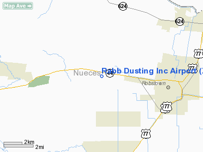
Location & QuickFacts
| FAA Information Effective: | 2008-09-25 |
| Airport Identifier: | XS66 |
| Airport Status: | Operational |
| Longitude/Latitude: | 097-44-36.9870W/27-48-14.0870N
-97.743608/27.803913 (Estimated) |
| Elevation: | 83 ft / 25.30 m (Estimated) |
| Land: | 0 acres |
| From nearest city: | 3 nautical miles W of Robstown, TX |
| Location: | Nueces County, TX |
| Magnetic Variation: | 07E (1985) |
Owner & Manager
| Ownership: | Privately owned |
| Owner: | Aubrey Harper Jr |
| Address: | Rt 2 Box 263
Robstown, TX 78380 |
| Manager: | Aubrey Harper Jr |
| Address: | Rt 2 Box 263
Robstown, TX 78380 |
| Phone number: | 512-387-7511 |
Airport Operations and Facilities
| Airport Use: | Private |
| Wind indicator: | Yes |
| Segmented Circle: | No |
| Control Tower: | No |
| Landing fee charge: | No |
| Sectional chart: | Brownsville |
| Region: | ASW - Southwest |
| Boundary ARTCC: | ZHU - Houston |
| Tie-in FSS: | SJT - San Angelo |
| FSS on Airport: | No |
| FSS Toll Free: | 1-800-WX-BRIEF |
Runway Information
Runway 16/34
| Dimension: | 2000 x 35 ft / 609.6 x 10.7 m |
| Surface: | GRAVEL, |
| |
Runway 16 |
Runway 34 |
| Traffic Pattern: | Left | Left |
|
Runway 18/36
| Dimension: | 2200 x 25 ft / 670.6 x 7.6 m |
| Surface: | ASPH, |
| Edge Lights: | Low |
| |
Runway 18 |
Runway 36 |
| Traffic Pattern: | Left | Left |
| Displaced threshold: | 300.00 ft | 0.00 ft |
|
Radio Navigation Aids
| ID |
Type |
Name |
Ch |
Freq |
Var |
Dist |
| TKB | NDB | Kleberg County | | 347.00 | 06E | 21.7 nm |
| BEA | NDB | Beeville | | 284.00 | 07E | 34.1 nm |
| MNO | NDB | Mellon Ranch | | 375.00 | 06E | 40.4 nm |
| RKP | NDB | Rockport | | 391.00 | 06E | 40.8 nm |
| BKS | NDB | Brooks County | | 353.00 | 06E | 41.2 nm |
| NOG | TACAN | Orange Grove | 063X | | 09E | 16.8 nm |
| NQI | TACAN | Kingsville | 125X | | 09E | 18.6 nm |
| ALI | VOR | Alice | | 114.50 | 06E | 15.3 nm |
| CRP | VORTAC | Corpus Christi | 102X | 115.50 | 09E | 17.0 nm |
| NGP | VORTAC | Truax | 087X | 114.00 | 06E | 24.9 nm |
| THX | VORTAC | Three Rivers | 051X | 111.40 | 08E | 47.3 nm |
Remarks
- STORAGE TANKS NEAR RWY 36.
- VFR OPERATIONS; RWY 18 THRESHOLD LOCATED TO PROVIDE 20:1 CLEARANCE OVER STATE ROUTE 44.
Images and information placed above are from
http://www.airport-data.com/airport/XS66/
We thank them for the data!
| General Info
|
| Country |
United States
|
| State |
TEXAS
|
| FAA ID |
XS66
|
| Latitude |
27-48-14.087N
|
| Longitude |
097-44-36.987W
|
| Elevation |
83 feet
|
| Near City |
ROBSTOWN
|
We don't guarantee the information is fresh and accurate. The data may
be wrong or outdated.
For more up-to-date information please refer to other sources.
|
|


