 |
|
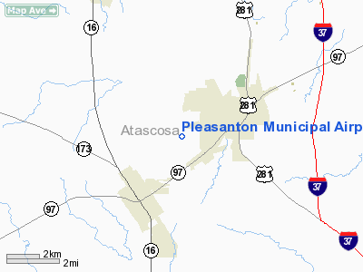
Location & QuickFacts
| FAA Information Effective: | 2008-09-25 |
| Airport Identifier: | PEZ |
| Airport Status: | Operational |
| Longitude/Latitude: | 098-31-11.9450W/28-57-15.0820N
-98.519985/28.954189 (Estimated) |
| Elevation: | 430 ft / 131.06 m (Surveyed) |
| Land: | 94 acres |
| From nearest city: | 3 nautical miles W of Pleasanton, TX |
| Location: | Atascosa County, TX |
| Magnetic Variation: | 06E (2000) |
Owner & Manager
| Ownership: | Publicly owned |
| Owner: | City Of Pleasanton |
| Address: | Box 209
Pleasanton, TX 78064 |
| Phone number: | 830-569-3867 |
| Manager: | Kathy Coronado, City Mgr |
| Address: | Po Box 209
Pleasanton, TX 78064 |
| Phone number: | 830-569-3867 |
Airport Operations and Facilities
| Airport Use: | Open to public |
| Wind indicator: | Yes |
| Segmented Circle: | Yes |
| Control Tower: | No |
| Lighting Schedule: | DUSK-DAWN
MIRL RY 16/34 PRESET LOW INTST; TO INCR INTST ACTVT - CTAF. |
| Beacon Color: | Clear-Green (lighted land airport) |
| Landing fee charge: | No |
| Sectional chart: | San Antonio |
| Region: | ASW - Southwest |
| Boundary ARTCC: | ZHU - Houston |
| Tie-in FSS: | SJT - San Angelo |
| FSS on Airport: | No |
| FSS Toll Free: | 1-800-WX-BRIEF |
| NOTAMs Facility: | SJT (NOTAM-d service avaliable) |
| Federal Agreements: | NGY |
Airport Communications
| CTAF: | 122.700 |
| Unicom: | 122.700
UNICOM MONITORED IN SHOP HANGAR. |
Airport Services
| Fuel available: | 100LL
FUEL SELF-SERVICE WITH MAJOR CREDIT CARD. |
| Bottled Oxygen: | NONE |
| Bulk Oxygen: | NONE |
Runway Information
Runway 16/34
| Dimension: | 4000 x 75 ft / 1219.2 x 22.9 m |
| Surface: | ASPH, Good Condition |
| Weight Limit: | Single wheel: 4000 lbs. |
| Edge Lights: | Medium |
| |
Runway 16 |
Runway 34 |
| Longitude: | 098-31-18.4920W | 098-31-05.3970W |
| Latitude: | 28-57-34.0270N | 28-56-56.1360N |
| Elevation: | 430.00 ft | 400.00 ft |
| Alignment: | 127 | 127 |
| Traffic Pattern: | Left | Left |
| Markings: | Non-precision instrument, Good Condition | Non-precision instrument, Good Condition |
| Crossing Height: | 25.00 ft | 35.00 ft |
| Displaced threshold: | 403.00 ft | 0.00 ft |
| VASI: | 2-light PAPI on left side | 2-light PAPI on left side |
| Visual Glide Angle: | 4.00° | 3.00° |
| Obstruction: | 39 ft tree, 260.0 ft from runway, 270 ft left of centerline, 1:1 slope to clear
APCH SLOPE 0:1 TO DSPLCD THLD FM +6 FT FENCE AT DSPLCD THLD 199 FT RIGHT ON RISING GROUND.
+4 FT FENCE FM THLD TO 200 FT AT 200 FT R; +4 FT FENCE 98 FT FM THLD ON CNTRLN; +15 FT ROAD 137 FT FM THLD ON CNTRLN. | 3 ft fence, 200.0 ft from runway, 200 ft left of centerline
+3 FT FENCE FM THLD TO 200 FT AT 200 FT LEFT, +25 FT TREE 160 FT FM THLD 186 FT LEFT. |
|
Radio Navigation Aids
| ID |
Type |
Name |
Ch |
Freq |
Var |
Dist |
| HHH | NDB | Devine | | 359.00 | 07E | 24.7 nm |
| CVB | NDB | Castroville | | 338.00 | 08E | 29.2 nm |
| HMA | NDB | Hondo | | 329.00 | 08E | 42.5 nm |
| KSY | TACAN | Kelly | 057X | | 07E | 26.5 nm |
| DHK | TACAN | Randolph | 036X | | 09E | 37.4 nm |
| SSF | VOR | Stinson | | 108.40 | 09E | 18.7 nm |
| HDO | VOR/DME | Hondo | 31X | 109.40 | 08E | 41.9 nm |
| THX | VORTAC | Three Rivers | 051X | 111.40 | 08E | 33.3 nm |
| RND | VORTAC | Randolph | 70X | 112.30 | 09E | 36.1 nm |
| SAT | VORTAC | San Antonio | 115X | 116.80 | 08E | 41.6 nm |
| COT | VORTAC | Cotulla | 105X | 115.80 | 09E | 43.3 nm |
| SAT | VOT | San Antonio Intl | | 110.40 | | 34.9 nm |
Images and information placed above are from
http://www.airport-data.com/airport/PEZ/
We thank them for the data!
| General Info
|
| Country |
United States
|
| State |
TEXAS
|
| FAA ID |
PEZ
|
| Latitude |
28-57-15.082N
|
| Longitude |
098-31-11.945W
|
| Elevation |
430 feet
|
| Near City |
PLEASANTON
|
We don't guarantee the information is fresh and accurate. The data may
be wrong or outdated.
For more up-to-date information please refer to other sources.
|
|


