 |
|
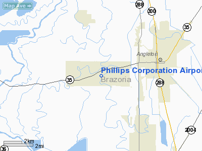
Phillips Corporation Airport |
Location & QuickFacts
| FAA Information Effective: | 2008-09-25 |
| Airport Identifier: | 46TX |
| Airport Status: | Operational |
| Longitude/Latitude: | 095-29-42.7940W/29-09-02.8790N
-95.495221/29.150800 (Estimated) |
| Elevation: | 30 ft / 9.14 m (Estimated) |
| Land: | 0 acres |
| From nearest city: | 4 nautical miles W of Angleton, TX |
| Location: | Brazoria County, TX |
| Magnetic Variation: | 06E (1985) |
Owner & Manager
| Ownership: | Privately owned |
| Owner: | Phillips Corp |
| Address: | P.o. Box 29
Angleton, TX 77516-0029 |
| Manager: | Jimmy Phillips Jr |
| Address: | Drawer Jj
Angleton, TX 77515 |
| Phone number: | 713-849-6170 |
Airport Operations and Facilities
| Airport Use: | Private |
| Wind indicator: | Yes |
| Segmented Circle: | No |
| Control Tower: | No |
| Landing fee charge: | No |
| Sectional chart: | Houston |
| Region: | ASW - Southwest |
| Boundary ARTCC: | ZHU - Houston |
| Tie-in FSS: | CXO - Montgomery County |
| FSS on Airport: | No |
| FSS Toll Free: | 1-800-WX-BRIEF |
Airport Services
| Airframe Repair: | NONE |
| Power Plant Repair: | NONE |
Runway Information
Runway 03/21
| Dimension: | 2200 x 50 ft / 670.6 x 15.2 m |
| Surface: | TURF, |
| |
Runway 03 |
Runway 21 |
| Traffic Pattern: | Left | Left |
| Obstruction: | 50 ft trees, 300.0 ft from runway | 70 ft trees, 200.0 ft from runway |
|
Radio Navigation Aids
| ID |
Type |
Name |
Ch |
Freq |
Var |
Dist |
| SYG | NDB | Sandy Point | | 402.00 | 05E | 21.2 nm |
| BYY | NDB | Bay City | | 344.00 | 06E | 21.9 nm |
| SGR | NDB | Hull | | 388.00 | 05E | 30.1 nm |
| ARM | NDB | Wharton | | 245.00 | 06E | 35.0 nm |
| JPA | NDB | Sanjac | | 347.00 | 05E | 38.3 nm |
| GLS | NDB | Galveston | | 206.00 | 08E | 40.3 nm |
| LYD | NDB | Lakeside | | 249.00 | 05E | 41.1 nm |
| EYQ | NDB | Weiser | | 286.00 | 06E | 47.7 nm |
| EFD | TACAN | Ellington | 031X | | 05E | 32.5 nm |
| HUB | VOR/DME | Hobby | 118X | 117.10 | 05E | 32.4 nm |
| MHF | VOR/DME | Trinity | 083X | 113.60 | 07E | 45.8 nm |
| VUH | VORTAC | Scholes | 077X | 113.00 | 06E | 33.7 nm |
| PSX | VORTAC | Palacios | 120X | 117.30 | 08E | 48.6 nm |
| IAH | VORTAC | Humble | 113X | 116.60 | 05E | 49.1 nm |
| HOU | VOT | Houston Wm P Hobby | | 108.40 | | 31.8 nm |
Images and information placed above are from
http://www.airport-data.com/airport/46TX/
We thank them for the data!
| General Info
|
| Country |
United States
|
| State |
TEXAS
|
| FAA ID |
46TX
|
| Latitude |
29-09-02.879N
|
| Longitude |
095-29-42.794W
|
| Elevation |
30 feet
|
| Near City |
ANGLETON
|
We don't guarantee the information is fresh and accurate. The data may
be wrong or outdated.
For more up-to-date information please refer to other sources.
|
|


