|
 |
|
||||
|
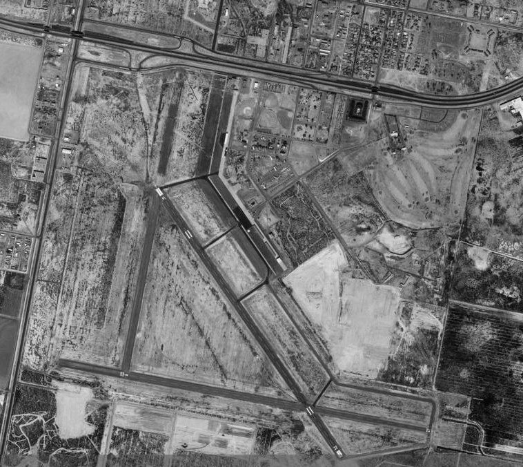
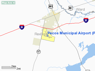
Pecos Municipal Airport (IATA: PEQ, ICAO: KPEQ, FAA LID: PEQ) is a city-owned, public-use airport located two nautical miles (3.7 km) southwest of the central business district of Pecos, a city in Reeves County, Texas, United States. According to the FAA's National Plan of Integrated Airport Systems for 2009–2013, it is categorized as a general aviation airport. HistoryThe airport was opened as Pecos Airport. the airport initially included 400 acres located three miles south and slightly west of Pecos. Proceeds of a $10,000 bond issue authorized in a special election on September 14, 1940, were used for land purchase. The site was cleared, fenced, and graded under a WPA contract. As the war in Europe intensified, the desire of Pecos residents for a military base increased. Efforts were unsuccessful, however, until the attack on Pearl Harbor galvanized the Army Air Force into launching a training program, first for 50,000 and then for 70,000 pilots. At that time, Pecos was chosen as one of five new training fields. The United States Army Air Forces used Pecos Airport as a training airfield by the Army Air Forces Flying Training Command, West Coast Training Center (later the Western Flying Training Command). It was named Pecos Army Airfield. Pecos Army Air Field was activated on 11 July 1942 while still under construction. Because more land was required for the long runways necessary for novice pilots, the town council promptly called another bond election to authorize an additional $50,000. The field's size was increased to 1,834 acres, accommodating one runway 7,200 feet long and two others of 6,200 feet each. Following the formal announcement of a military base on March 25, 1942, construction contracts were let in May. Both the construction and the early flying phases of the base were handicapped by wind-whipped dust until late 1943, when extensive palliation efforts relieved the situation. The first commander, Col. Harry C. Wisehart, arrived on June 28, 1942, as project officer. The first military units to arrive were the 744th School Squadron (100 men) and the 341st Air Base Squadron (18 men). A week later five more school squadrons, each with 80 men, arrived from Lemoore Army Air Field, California, as the vanguard of the eventual population of 4,000. It first was used as a basic pilot school. The field was redesignated an advanced pilot school (twin-engine) on December 29, 1943, and had four auxiliary fields. At its peak, on April 30, 1944, the field numbered 4,304 people, including 482 officers, 972 cadets and student officers, 2,218 enlisted personnel (including 200 WACs), and 604 civilian employees, of which 25 were WASPs. This population, nearly as large as that of Pecos itself, placed a great strain on the town's resources. PAAF consisted chiefly of "theater of operations" type buildings-cheap, rapidly constructed, single-story structures covered with black tarpaper. It also had two large hangars, extensive maintenance facilities, and barely adequate eating and living quarters. Off-base housing in Pecos and neighboring towns was very limited, for an even larger airfield, Pyote,qv had been built twenty miles east. PAAF eventually set up dormitories and small apartments to house civilian employees and some military families on base. The first Pecos class, designated 43-A, graduated 133 cadets and student officers after nine weeks of combined ground school and flight training. In all, PAAF produced seventeen classes of basic pilots at roughly one-month intervals, the classes varying from ninety to 528 men. With an elimination rate ranging from 3 percent to 29 percent per class, a total of 3,367 finished the course. As basic pilot training ended on January 7, 1944, no time was lost converting to advanced pilot training by the newly redesignated 3027th Army Air Forces Base Unit (Advanced 2-Engine). Col. Olin C. Bushey relieved Colonel Wisehart as commander on August 28, 1943, and was succeeded in turn by colonels Harry B. Fisher (August 19, 1944) and Harold D. Smith (March 3, 1945). Advanced classes ranged in size from 245 to 526, and fewer students were washed out than in basic training. When the last advanced class at PAAF, 45-B, received silver wings and commissions as second lieutenants or appointments as flight officers on April 15, 1945, the active mission of the field ended. Twelve classes had by then produced 4,215 pilots. The airfield was placed on "temporary standby" status on May 1, 1945, and was never again an active military installation. Although the city tried to develop a continuing federal use for the field, it was closed on May 12, 1945, and was deactivated on August 30. A year later it was returned to municipal control. Over the years part of the field was sold off, and Interstate Highway 20 cut through it. Sold portions were used for the site of a hospital, zoo, and trailer park. The Pecos Municipal Airport was on the remaining airfield property, but most of the original facilities were torn down. The last hangar came down about 1986, and the last barracks were torn down about 1987. In the 1990s the airport still used four runways that had been maintained since the 1940s. An original ramp and rotating beacon were still in use. The West of the Pecos Museum in Pecos maintained a permanent exhibit at Pecos Army Air Field. Facilities and aircraftPecos Municipal Airport covers an area of 771 acres (312 ha) at an elevation of 2,613 feet (796 m) above mean sea level. It has two asphalt paved runways: 9/27 is 5,953 by 80 feet (1,814 x 24 m) and 14/32 is 6,236 by 80 feet (1,901 x 24 m). For the 12-month period ending August 12, 2009, the airport had 20,050 aircraft operations, an average of 54 per day: 71% general aviation and 29% military. At that time there were 13 aircraft based at this airport: 84.6% single-engine, 7.7% multi-engine and 7.7% helicopter. The above content comes from Wikipedia and is published under free licenses – click here to read more.
Location & QuickFacts
Owner & Manager
Airport Operations and Facilities
Airport Communications
Airport Services
Runway InformationRunway 09/27
Runway 14/32
Radio Navigation Aids
Images and information placed above are from We thank them for the data!
We don't guarantee the information is fresh and accurate. The data may
be wrong or outdated.
|
|||||||||||||||||||||||||||||||||||||||||||||||||||||||||||||||||||||||||||||||||||||||||||||||||||||||||||||||||||||||||||||||||||||||||||||||||||||||||||||||||||||||||||||||||||||||||||||||||||||||||||||||||||||||||||||||||||||||||||||||||||||||||||||||||||||||||||||||||||||||||||||||||||||||||||||||

 |
|
Copyright 2004-2026 © by Airports-Worldwide.com, Vyshenskoho st. 36, Lviv 79010, Ukraine Legal Disclaimer |