|
|
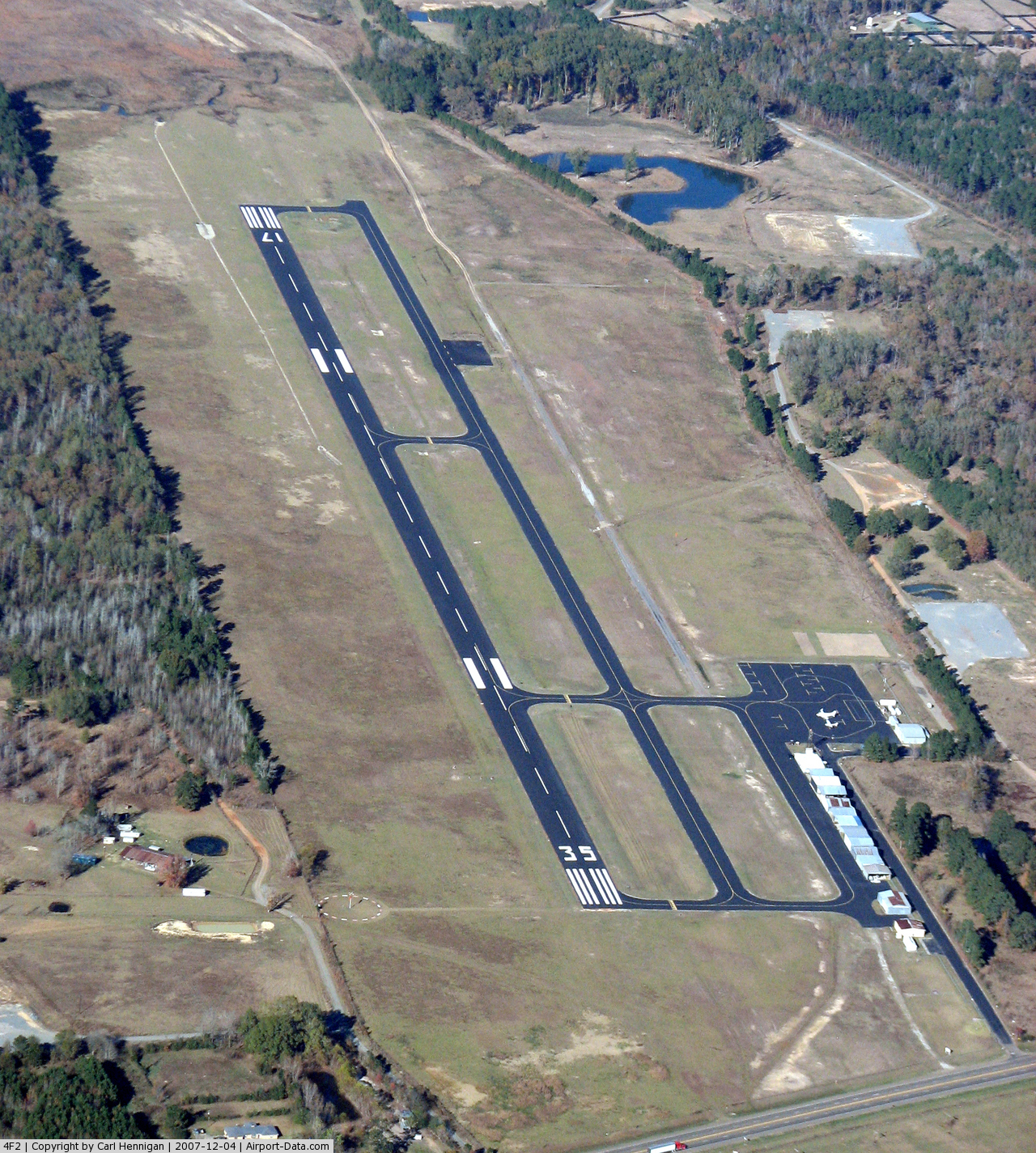
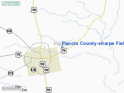
Panola County-sharpe Field Airport |
 |
(Click on the photo to enlarge) |
Location & QuickFacts
| FAA Information Effective: | 2008-09-25 |
| Airport Identifier: | 4F2 |
| Airport Status: | Operational |
| Longitude/Latitude: | 094-17-55.7000W/32-10-33.9000N
-94.298806/32.176083 (Estimated) |
| Elevation: | 248 ft / 75.59 m (Surveyed) |
| Land: | 112 acres |
| From nearest city: | 2 nautical miles E of Carthage, TX |
| Location: | Panola County, TX |
| Magnetic Variation: | 04E (1995) |
Owner & Manager
| Ownership: | Publicly owned |
| Owner: | Panola Co |
| Address: | Panola Co. Courthouse
Carthage, TX 75633 |
| Phone number: | 903-693-0391
EMERGENCY PHONE NRS: 903-754-2741 (CELL), SHERIFF: 903-693-8665, FAX: 903-693-7894. |
| Manager: | John De Presca, Jr. |
| Address: | 1305 Highway 79 North
Carthage, TX 75633 |
| Phone number: | 903-693-7856 |
Airport Operations and Facilities
| Airport Use: | Open to public |
| Wind indicator: | Yes |
| Segmented Circle: | Yes |
| Control Tower: | No |
| Lighting Schedule: | DUSK-DAWN
MIRL RY 17/35 PRESET LOW INTST; TO INCR INTST ACTVT - CTAF. |
| Beacon Color: | Clear-Green (lighted land airport) |
| Landing fee charge: | No |
| Sectional chart: | Dallas-ft Worth |
| Region: | ASW - Southwest |
| Boundary ARTCC: | ZFW - Fort Worth |
| Tie-in FSS: | FTW - Fort Worth |
| FSS on Airport: | No |
| FSS Phone: | 817-541-3474 |
| FSS Toll Free: | 1-800-WX-BRIEF |
| NOTAMs Facility: | FTW (NOTAM-d service avaliable) |
| Federal Agreements: | NGY |
Airport Communications
| CTAF: | 122.800 |
| Unicom: | 122.800 |
Airport Services
| Fuel available: | 100LLA
FUEL AVBL 24 HRS SELF-SERVE WITH MAJOR CREDIT CARD. |
| Bottled Oxygen: | NONE |
| Bulk Oxygen: | NONE |
Runway Information
Runway 17/35
| Dimension: | 4000 x 75 ft / 1219.2 x 22.9 m |
| Surface: | ASPH, Good Condition |
| Edge Lights: | Medium |
| |
Runway 17 |
Runway 35 |
| Longitude: | 094-17-56.6228W | 094-17-54.8304W |
| Latitude: | 32-10-53.6551N | 32-10-14.1000N |
| Elevation: | 244.00 ft | 248.00 ft |
| Alignment: | 127 | 127 |
| Traffic Pattern: | Left | Left |
| Markings: | Non-precision instrument, Good Condition | Non-precision instrument, Good Condition |
| VASI: | 4-light PAPI on left side | 4-light PAPI on left side |
| Visual Glide Angle: | 3.00° | 4.00° |
| Obstruction: | 92 ft trees, 2800.0 ft from runway, 28:1 slope to clear | 57 ft trees, 1200.0 ft from runway, 20 ft right of centerline, 17:1 slope to clear |
|
Radio Navigation Aids
| ID |
Type |
Name |
Ch |
Freq |
Var |
Dist |
| RPF | NDB | Carthage | | 332.00 | 04E | 0.3 nm |
| CZJ | NDB | Amason | | 341.00 | 04E | 21.9 nm |
| MSD | NDB | Mansfield | | 414.00 | 04E | 28.0 nm |
| HNO | NDB | Henderson | | 371.00 | 06E | 28.6 nm |
| GXD | NDB | Nacogdoches | | 391.00 | 05E | 37.9 nm |
| VIV | NDB | Vivian | | 284.00 | 06E | 43.6 nm |
| OC | NDB | Nados | | 253.00 | 05E | 46.8 nm |
| ABG | NDB | Ambassador | | 404.00 | 07E | 48.1 nm |
| BAD | TACAN | Barksdale | 105X | | 05E | 37.6 nm |
| DTN | VOR | Downtown | | 108.60 | 07E | 35.8 nm |
| GGG | VORTAC | Gregg County | 070X | 112.30 | 07E | 27.3 nm |
| EMG | VORTAC | Elm Grove | 049X | 111.20 | 07E | 38.2 nm |
| EIC | VORTAC | Belcher | 121X | 117.40 | 07E | 43.5 nm |
| SHV | VOT | Shreveport Regional | | 108.20 | | 35.3 nm |
Remarks
Images and information placed above are from
http://www.airport-data.com/airport/4F2/
We thank them for the data!
| General Info
|
| Country |
United States
|
| State |
TEXAS
|
| FAA ID |
4F2
|
| Latitude |
32-10-33.900N
|
| Longitude |
094-17-55.700W
|
| Elevation |
248 feet
|
| Near City |
CARTHAGE
|
We don't guarantee the information is fresh and accurate. The data may
be wrong or outdated.
For more up-to-date information please refer to other sources.
|
|