 |
|
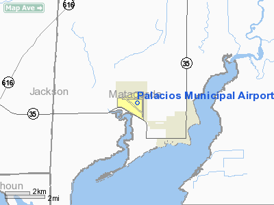
| Palacios Municipal Airport |
 |
| IATA: GLE – ICAO: KGLE |
| Summary |
| Airport type |
Public |
| Operator |
City of Palacios, Texas |
| Location |
Palacios, Texas, USA |
| Elevation AMSL |
14 ft / 4.3 m |
| Coordinates |
28°43′39.0329″N 096°15′03.4474″W / 28.727509139°N 96.250957611°W / 28.727509139; -96.250957611Coordinates: 28°43′39.0329″N 096°15′03.4474″W / 28.727509139°N 96.250957611°W / 28.727509139; -96.250957611 |
| Runways |
| Direction |
Length |
Surface |
| ft |
m |
| 08/26 |
5,000 |
1,524 |
Asphalt |
| 13/31 |
5,000 |
1,524 |
Asphalt |
| 17/35 |
5,000 |
1,524 |
Asphalt |
Palacios Municipal Airport (IATA: PSX, ICAO: KPSX) is a commercial airport located within city limits, 3 miles NW of central Palacios, Texas. History
Camp Palacios was originally established as a summer training camp for the 36th Infantry Division of the TX National Guard after the Palacios Campsite Association donated the land to the state in 1926. As a result of World War II, Palacios Army Airfield was constructed in 1943 and opened in August by the United States Army Air Forces as a maintenance depot and supply facility for Air Technical Service Command.
At the end of the war the airfield was determined to be excess by the military and turned over to the local government for civil use.
The above content comes from Wikipedia and is published under free licenses – click here to read more.
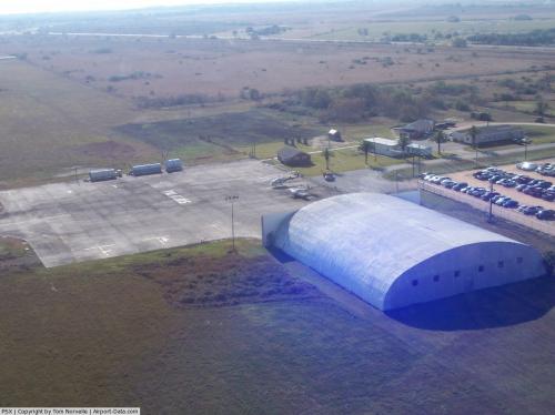 |
(Click on the photo to enlarge) |
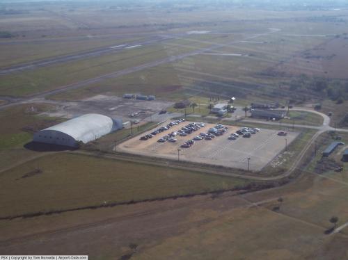 |
(Click on the photo to enlarge) |
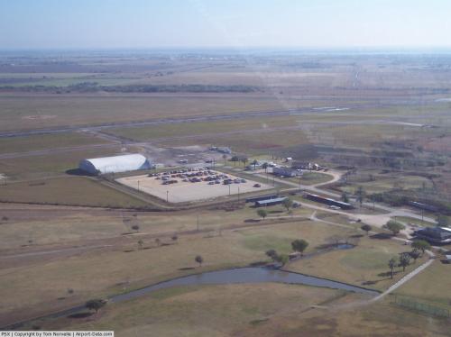 |
(Click on the photo to enlarge) |
Location & QuickFacts
| FAA Information Effective: | 2008-09-25 |
| Airport Identifier: | PSX |
| Airport Status: | Operational |
| Longitude/Latitude: | 096-15-03.4000W/28-43-39.0000N
-96.250944/28.727500 (Estimated) |
| Elevation: | 14 ft / 4.27 m (Surveyed) |
| Land: | 1538 acres |
| From nearest city: | 3 nautical miles NW of Palacios, TX |
| Location: | Matagorda County, TX |
| Magnetic Variation: | 08E (1965) |
Owner & Manager
| Ownership: | Publicly owned |
| Owner: | City Of Palacios |
| Address: | Box 845
Palacios, TX 77465 |
| Phone number: | 361-972-3605 |
| Manager: | Charles Winfield
CITY ADMINISTRATOR. |
| Address: | Po Box 845
Palacios, TX 77465 |
| Phone number: | 361-972-3605 |
Airport Operations and Facilities
| Airport Use: | Open to public |
| Wind indicator: | Yes |
| Segmented Circle: | Yes |
| Control Tower: | No |
| Lighting Schedule: | DUSK-DAWN
MIRL RY 13/31 PRESET ON LOW INTST; TO INCR INTST ACTVT - CTAF. |
| Beacon Color: | Clear-Green (lighted land airport) |
| Landing fee charge: | No |
| Sectional chart: | Houston |
| Region: | ASW - Southwest |
| Boundary ARTCC: | ZHU - Houston |
| Tie-in FSS: | CXO - Montgomery County |
| FSS on Airport: | No |
| FSS Toll Free: | 1-800-WX-BRIEF
FOR FP FILING CALL CXO FSS 1-800-992-7433. |
| NOTAMs Facility: | PSX (NOTAM-d service avaliable) |
| Federal Agreements: | NPR |
Airport Communications
| CTAF: | 122.800 |
| Unicom: | 122.800 |
Airport Services
| Fuel available: | 100LL
FUEL SELF-SERVICE WITH CREDIT CARD. |
Runway Information
Runway 08/26
| Dimension: | 5001 x 150 ft / 1524.3 x 45.7 m |
| Surface: | CONC, Fair Condition |
| Weight Limit: | Single wheel: 46000 lbs.
Dual wheel: 58000 lbs.
Dual tandem wheel: 105000 lbs. |
| |
Runway 08 |
Runway 26 |
| Longitude: | 096-15-43.5126W | 096-14-47.3378W |
| Latitude: | 28-43-49.3959N | 28-43-49.2140N |
| Elevation: | 11.00 ft | 12.00 ft |
| Alignment: | 90 | 127 |
| Traffic Pattern: | Left | Left |
| Markings: | Basic, Poor Condition
RY 08/26 MARKINGS VERY FADED. | Basic, Poor Condition |
| Obstruction: | 11 ft trees, 572.0 ft from runway, 75 ft left of centerline, 33:1 slope to clear | 20 ft tower, 697.0 ft from runway, 280 ft left of centerline, 24:1 slope to clear |
|
Runway 13/31
| Dimension: | 5001 x 150 ft / 1524.3 x 45.7 m |
| Surface: | CONC, Good Condition |
| Weight Limit: | Single wheel: 46000 lbs.
Dual wheel: 58000 lbs.
Dual tandem wheel: 105000 lbs. |
| Edge Lights: | Medium |
| |
Runway 13 |
Runway 31 |
| Longitude: | 096-15-26.4653W | 096-14-46.8871W |
| Latitude: | 28-43-50.6070N | 28-43-15.4715N |
| Elevation: | 12.00 ft | 14.00 ft |
| Alignment: | 127 | 127 |
| Traffic Pattern: | Left | Left |
| Markings: | Non-precision instrument, Good Condition | Non-precision instrument, Good Condition |
| Runway End Identifier: | Yes | Yes |
| Obstruction: | , 50:1 slope to clear | 8 ft tree, 490.0 ft from runway, 195 ft right of centerline, 36:1 slope to clear |
|
Runway 17/35
| Dimension: | 5001 x 150 ft / 1524.3 x 45.7 m |
| Surface: | CONC, Fair Condition |
| Weight Limit: | Single wheel: 46000 lbs.
Dual wheel: 58000 lbs.
Dual tandem wheel: 105000 lbs. |
| |
Runway 17 |
Runway 35 |
| Longitude: | 096-14-48.1424W | 096-14-48.3493W |
| Latitude: | 28-43-59.5087N | 28-43-09.9937N |
| Elevation: | 11.00 ft | 14.00 ft |
| Alignment: | 127 | 0 |
| Traffic Pattern: | Left | Left |
| Markings: | Basic, Poor Condition
RY 17/35 MARKINGS VERY FADED. | Basic, Poor Condition |
|
Radio Navigation Aids
| ID |
Type |
Name |
Ch |
Freq |
Var |
Dist |
| PKV | NDB | Port Lavaca | | 515.00 | 05E | 23.2 nm |
| BYY | NDB | Bay City | | 344.00 | 06E | 25.3 nm |
| ARM | NDB | Wharton | | 245.00 | 06E | 32.1 nm |
| VCT | VOR/DME | Victoria | 027X | 109.00 | 06E | 39.7 nm |
| PSX | VORTAC | Palacios | 120X | 117.30 | 08E | 3.7 nm |
Images and information placed above are from
http://www.airport-data.com/airport/PSX/
We thank them for the data!
| General Info
|
| Country |
United States
|
| State |
TEXAS
|
| FAA ID |
PSX
|
| Latitude |
28-43-39.064N
|
| Longitude |
096-15-03.483W
|
| Elevation |
15 feet
|
| Near City |
PALACIOS
|
We don't guarantee the information is fresh and accurate. The data may
be wrong or outdated.
For more up-to-date information please refer to other sources.
|
|


