 |
|
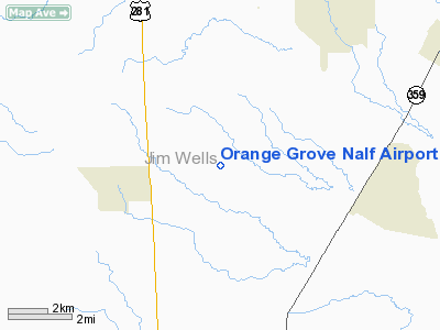
Orange Grove Nalf Airport |
Coordinates: 27°54′04″N 098°03′06″W / 27.90111°N 98.05167°W / 27.90111; -98.05167
| NALF Orange Grove |
| IATA: none – ICAO: KNOG – FAA LID: NOG |
| Summary |
| Airport type |
Military |
| Owner |
United States Navy |
| Location |
Jim Wells County, near Orange Grove, Texas |
| Elevation AMSL |
257 ft / 78 m |
| Runways |
| Direction |
Length |
Surface |
| ft |
m |
| 1/19 |
8,000 |
2,438 |
PEM |
| 13/31 |
8,000 |
2,438 |
PEM |
| Source: Federal Aviation Administration |
Naval Auxiliary Landing Field Orange Grove or NALF Orange Grove (ICAO: KNOG, FAA LID: NOG) is a military airport located southwest of Orange Grove, a city in Jim Wells County, Texas, United States. It covers an area of 1373 acres. Owned by the United States Navy, it supports pilot training for NAS Kingsville. It has two runways, 1/19 and 13/31, each measuring 8,000 x 200 ft. (2,438 x 61 m).
Although most U.S. airports use the same three-letter location identifier for the FAA and IATA, NALF Orange Grove is assigned NOG by the FAA but has no designation from the IATA (which assigned NOG to Nogales International Airport in Nogales, Sonora, Mexico).
The above content comes from Wikipedia and is published under free licenses – click here to read more.
Location & QuickFacts
| FAA Information Effective: | 2008-09-25 |
| Airport Identifier: | NOG |
| Airport Status: | Operational |
| Longitude/Latitude: | 098-03-06.0000W/27-54-04.2000N
-98.051667/27.901167 (Estimated) |
| Elevation: | 257 ft / 78.33 m (Estimated) |
| Land: | 0 acres |
| From nearest city: | 8 nautical miles N of Orange Grove, TX |
| Location: | Jim Wells County, TX |
| Magnetic Variation: | 09E (1965) |
Owner & Manager
| Ownership: | Navy owned |
| Owner: | Us Navy |
| Address: | Oceanographic Ofc - Code 3142
Washington, DC 20373 |
| Address: |
|
Airport Operations and Facilities
| Airport Use: | Private |
| Segmented Circle: | No |
| Control Tower: | Yes |
| Lighting Schedule: | DUSK-DAWN |
| Beacon Color: | Split-Clear-Green (lighted military airport) |
| Sectional chart: | Brownsville |
| Region: | ASW - Southwest |
| Boundary ARTCC: | ZHU - Houston |
| Tie-in FSS: | SJT - San Angelo |
| FSS on Airport: | No |
| FSS Toll Free: | 1-800-WX-BRIEF |
| NOTAMs Facility: | SJT |
Airport Services
| Bottled Oxygen: | NONE |
| Bulk Oxygen: | NONE |
Runway Information
Runway 01/19
| Dimension: | 8000 x 200 ft / 2438.4 x 61.0 m |
| Surface: | PEM, |
| Pavement Class: | 25 /R/C/W/T |
| Edge Lights: | Medium |
| |
Runway 01 |
Runway 19 |
| Traffic Pattern: | Left | Left |
| Arresting: | E28 | E28 |
|
Runway 13/31
| Dimension: | 8000 x 200 ft / 2438.4 x 61.0 m |
| Surface: | PEM, |
| Pavement Class: | 19 /R/C/W/T |
| Weight Limit: | Dual wheel: 93000 lbs.
Dual tandem wheel: 166000 lbs.
Dual dual tandem wheel: 550000 lbs. |
| Edge Lights: | Medium |
| |
Runway 13 |
Runway 31 |
| ILS Type: | LOC/GS
| |
| Traffic Pattern: | Left | Left |
| Arresting: | E28 | E28 |
|
Radio Navigation Aids
| ID |
Type |
Name |
Ch |
Freq |
Var |
Dist |
| TKB | NDB | Kleberg County | | 347.00 | 06E | 17.8 nm |
| BEA | NDB | Beeville | | 284.00 | 07E | 31.2 nm |
| BKS | NDB | Brooks County | | 353.00 | 06E | 41.9 nm |
| HBV | NDB | Hebbronville | | 266.00 | 06E | 49.4 nm |
| NOG | TACAN | Orange Grove | 063X | | 09E | 0.6 nm |
| NQI | TACAN | Kingsville | 125X | | 09E | 27.5 nm |
| ALI | VOR | Alice | | 114.50 | 06E | 9.8 nm |
| CRP | VORTAC | Corpus Christi | 102X | 115.50 | 09E | 32.2 nm |
| THX | VORTAC | Three Rivers | 051X | 111.40 | 08E | 36.7 nm |
| NGP | VORTAC | Truax | 087X | 114.00 | 06E | 42.3 nm |
Remarks
- CAUTION: STUDENT JET TRNG IN VCNTY DUR OPR HR.
- RWY-LGTS: RWY 01 - OLS. RWY 19 - OLS.
- RWY-LGTS: RWY 13 - OLS. RWY 31 - OLS.
- SERVICE-LGT: OLS GS 3.25‘.
- RSTD: CNATRA USE ONLY EXC IN EMERG, TWR DSN 876-6140. NALF TO KINGSVILLE NAS, BASE OPS DSN 876-6108.
- TRAN ALERT: NO TRAN MAINT OR SVC AVBL. REFUEL CNATRA ACFT ONLY.
- BEARING STRENGTH RWY 13/31: ST119 SBTT320 TRT306.
- JASU: 1(NC-8A).
- FUEL: J8.
- FLUID: SP PRESAIR.
- OIL: O-156.
Images and information placed above are from
http://www.airport-data.com/airport/NOG/
We thank them for the data!
| General Info
|
| Country |
United States
|
| State |
TEXAS
|
| FAA ID |
NOG
|
| Latitude |
27-54-04.072N
|
| Longitude |
098-03-06.008W
|
| Elevation |
257 feet
|
| Near City |
ORANGE GROVE
|
We don't guarantee the information is fresh and accurate. The data may
be wrong or outdated.
For more up-to-date information please refer to other sources.
|
|


