 |
|
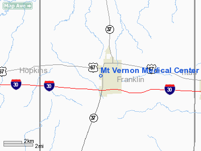
Mt Vernon Medical Center Heliport |
Location & QuickFacts
| FAA Information Effective: | 2008-09-25 |
| Airport Identifier: | 8TE5 |
| Airport Status: | Operational |
| Longitude/Latitude: | 095-14-08.7960W/33-10-34.4180N
-95.235777/33.176227 (Estimated) |
| Elevation: | 482 ft / 146.91 m (Estimated) |
| Land: | 0 acres |
| From nearest city: | 0 nautical miles N of Mount Vernon, TX |
| Location: | Franklin County, TX |
| Magnetic Variation: | 06E (1985) |
Owner & Manager
| Ownership: | Privately owned |
| Owner: | Mt Vernon Medical Center |
| Address: | Po Box 477
Mount Vernon, TX 75457 |
| Phone number: | 214-537-4552 |
| Manager: | Perry Henderson
HOSPITAL ADMINISTRATOR |
| Address: | Po Box 477
Mount Vernon, TX 75457 |
| Phone number: | 214-537-4552 |
Airport Operations and Facilities
| Airport Use: | Private
MEDICAL. |
| Wind indicator: | Yes |
| Segmented Circle: | No |
| Control Tower: | No |
| Lighting Schedule: | DUSK-DAWN |
| Sectional chart: | Dallas-ft Worth |
| Region: | ASW - Southwest |
| Boundary ARTCC: | ZFW - Fort Worth |
| Tie-in FSS: | FTW - Fort Worth |
| FSS Phone: | 817-541-3474 |
| FSS Toll Free: | 1-800-WX-BRIEF |
Runway Information
Helipad H1
| Dimension: | 25 x 25 ft / 7.6 x 7.6 m |
| Surface: | CONC, |
| |
Runway H1 |
Runway |
| Traffic Pattern: | Left | Left |
|
Radio Navigation Aids
| ID |
Type |
Name |
Ch |
Freq |
Var |
Dist |
| LST | NDB | Lone Star | | 305.00 | 05E | 29.0 nm |
| ABG | NDB | Ambassador | | 404.00 | 07E | 36.0 nm |
| SYW | NDB | Cash | | 428.00 | 05E | 43.5 nm |
| TY | NDB | Tyler | | 320.00 | 06E | 47.2 nm |
| IBO | NDB | Idabel | | 271.00 | 03E | 48.1 nm |
| MJF | TACAN | Arvilla | 033X | | 05E | 42.1 nm |
| SLR | VOR/DME | Sulphur Springs | 027X | 109.00 | 08E | 15.5 nm |
| UIM | VOR/DME | Quitman | 087X | 114.00 | 08E | 19.0 nm |
| PRX | VOR/DME | Paris | 083X | 113.60 | 07E | 24.5 nm |
Remarks
- PRVDD INGRESS/EGRESS ROUTES ARE ESTABLISHED TO/FROM SOUTH ONLY AND SOME TYPE OF RESTRAINING DEVICE IS INSTALLED BETWEEN LANDING AREA AND PARKING LOT TO RESTRICT PUBLIC ACCESS TO PAD.
Images and information placed above are from
http://www.airport-data.com/airport/8TE5/
We thank them for the data!
| General Info
|
| Country |
United States
|
| State |
TEXAS
|
| FAA ID |
8TE5
|
| Latitude |
33-10-34.418N
|
| Longitude |
095-14-08.796W
|
| Elevation |
482 feet
|
| Near City |
MOUNT VERNON
|
We don't guarantee the information is fresh and accurate. The data may
be wrong or outdated.
For more up-to-date information please refer to other sources.
|
|


