 |
|
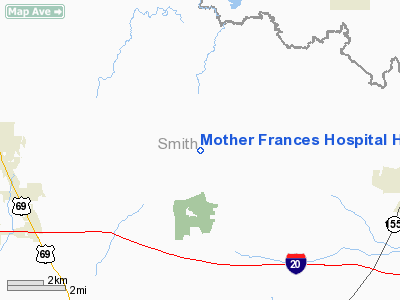
Mother Frances Hospital Heliport |
Location & QuickFacts
| FAA Information Effective: | 2008-09-25 |
| Airport Identifier: | TE18 |
| Airport Status: | Operational |
| Longitude/Latitude: | 095-17-23.8230W/32-30-33.5150N
-95.289951/32.509310 (Estimated) |
| Elevation: | 520 ft / 158.50 m (Estimated) |
| Land: | 0 acres |
| From nearest city: | 0 nautical miles N of Tyler, TX |
| Location: | Smith County, TX |
| Magnetic Variation: | 06E (1985) |
Owner & Manager
| Ownership: | Privately owned |
| Owner: | Mother Frances Hospital |
| Address: | 800 E. Dawson
Tyler, TX 75701 |
| Phone number: | 1-441-8677 |
| Manager: | Jim Lynn |
| Address: | 800 E. Dawson
Tyler, TX 75701 |
| Phone number: | 1-441-8677 |
Airport Operations and Facilities
| Airport Use: | Private
MEDICAL |
| Wind indicator: | Yes |
| Segmented Circle: | No |
| Control Tower: | No |
| Lighting Schedule: | PHONE REQ
FOR PERIMETER & FLOOD LGTS CALL 1-800-441-8677. |
| Sectional chart: | Dallas-ft Worth |
| Region: | ASW - Southwest |
| Boundary ARTCC: | ZFW - Fort Worth |
| Tie-in FSS: | FTW - Fort Worth |
| FSS Phone: | 817-541-3474 |
| FSS Toll Free: | 1-800-WX-BRIEF |
Airport Communications
Airport Services
Runway Information
Helipad H1
| Dimension: | 80 x 60 ft / 24.4 x 18.3 m |
| Surface: | ASPH, |
| |
Runway H1 |
Runway |
| Traffic Pattern: | Left | Left |
|
Radio Navigation Aids
| ID |
Type |
Name |
Ch |
Freq |
Var |
Dist |
| ABG | NDB | Ambassador | | 404.00 | 07E | 10.1 nm |
| TY | NDB | Tyler | | 320.00 | 06E | 10.7 nm |
| HNO | NDB | Henderson | | 371.00 | 06E | 29.1 nm |
| AHX | NDB | Athens | | 269.00 | 06E | 34.6 nm |
| LST | NDB | Lone Star | | 305.00 | 05E | 37.4 nm |
| JSO | NDB | Cherokee County | | 263.00 | 05E | 38.6 nm |
| CSZ | NDB | Crossroads | | 215.00 | 08E | 43.2 nm |
| LIQ | NDB | Lochridge Ranch | | 335.00 | 09E | 45.1 nm |
| SYW | NDB | Cash | | 428.00 | 05E | 48.5 nm |
| PSN | NDB | Palestine | | 375.00 | 04E | 48.6 nm |
| TYR | VOR/DME | Tyler | 089X | 114.20 | 06E | 10.9 nm |
| UIM | VOR/DME | Quitman | 087X | 114.00 | 08E | 22.6 nm |
| FZT | VOR/DME | Frankston | 051X | 111.40 | 06E | 28.9 nm |
| SLR | VOR/DME | Sulphur Springs | 027X | 109.00 | 08E | 43.4 nm |
| GGG | VORTAC | Gregg County | 070X | 112.30 | 07E | 27.8 nm |
Remarks
- PRVDD VFR/PR USE ONLY; WIND CONE BE INSTALLED; PLINES ARE MKD/LGTD; OBSTN LGTS PLACED ON LGT STANCHIONS LOCATED IN EMERGENCY ROOM PKG LOT; AND SECURITY GUARDS ARE PRVDD AT EMERGENCY ROOM PAD FOR PEDESTRIAN CONTROL.
Images and information placed above are from
http://www.airport-data.com/airport/TE18/
We thank them for the data!
| General Info
|
| Country |
United States
|
| State |
TEXAS
|
| FAA ID |
7TA4
|
| Latitude |
32-20-31.537N
|
| Longitude |
095-17-31.823W
|
| Elevation |
520 feet
|
| Near City |
TYLER
|
We don't guarantee the information is fresh and accurate. The data may
be wrong or outdated.
For more up-to-date information please refer to other sources.
|
|


