 |
|
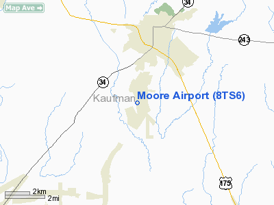
Location & QuickFacts
| FAA Information Effective: | 2008-09-25 |
| Airport Identifier: | 8TS6 |
| Airport Status: | Operational |
| Longitude/Latitude: | 096-19-20.9310W/32-31-59.4930N
-96.322481/32.533192 (Estimated) |
| Elevation: | 418 ft / 127.41 m (Estimated) |
| Land: | 0 acres |
| From nearest city: | 3 nautical miles S of Kaufman, TX |
| Location: | Kaufman County, TX |
| Magnetic Variation: | 06E (1985) |
Owner & Manager
| Ownership: | Privately owned |
| Owner: | Gerald D. Moore |
| Address: | Rt 5, Box 132a
Kaufman, TX 75142 |
| Phone number: | 214-932-4083 |
| Manager: | Gerald D. Moore |
| Address: | Rt 5, Box 132a
Kaufman, TX 75142 |
| Phone number: | 214-932-4083 |
Airport Operations and Facilities
| Airport Use: | Private |
| Wind indicator: | Yes |
| Segmented Circle: | No |
| Control Tower: | No |
| Landing fee charge: | No |
| Sectional chart: | Dallas-ft Worth |
| Region: | ASW - Southwest |
| Boundary ARTCC: | ZFW - Fort Worth |
| Tie-in FSS: | FTW - Fort Worth |
| FSS on Airport: | No |
| FSS Phone: | 817-541-3474 |
| FSS Toll Free: | 1-800-WX-BRIEF |
Runway Information
Runway 06/24
| Dimension: | 1835 x 40 ft / 559.3 x 12.2 m |
| Surface: | TURF, |
| |
Runway 06 |
Runway 24 |
| Traffic Pattern: | Left | Left |
| Obstruction: | | 30 ft pline |
|
Radio Navigation Aids
| ID |
Type |
Name |
Ch |
Freq |
Var |
Dist |
| JUG | NDB | Jecca | | 388.00 | 06E | 13.4 nm |
| AVZ | NDB | Travis | | 260.00 | 06E | 14.1 nm |
| PQF | NDB | Mesquite | | 248.00 | 06E | 19.6 nm |
| LNC | NDB | Lancaster | | 239.00 | 06E | 20.4 nm |
| CGQ | NDB | Powell | | 344.00 | 06E | 28.7 nm |
| RBD | NDB | Redbird | | 287.00 | 06E | 29.1 nm |
| SYW | NDB | Cash | | 428.00 | 05E | 29.9 nm |
| CRS | NDB | Corsicana | | 396.00 | 06E | 30.6 nm |
| MII | NDB | Caddo Mills | | 316.00 | 06E | 30.7 nm |
| XQH | NDB | Cedar Hill | | 353.00 | 08E | 33.3 nm |
| AHX | NDB | Athens | | 269.00 | 06E | 33.6 nm |
| CSZ | NDB | Crossroads | | 215.00 | 08E | 33.8 nm |
| LIQ | NDB | Lochridge Ranch | | 335.00 | 09E | 36.6 nm |
| PYF | NDB | Pyramid | | 418.00 | 06E | 40.8 nm |
| TY | NDB | Tyler | | 320.00 | 06E | 43.8 nm |
| MJF | TACAN | Arvilla | 033X | | 05E | 34.7 nm |
| CVE | VOR/DME | Cowboy | 109X | 116.20 | 06E | 36.4 nm |
| TTT | VOR/DME | Maverick | 078X | 113.10 | 06E | 41.6 nm |
| TYR | VOR/DME | Tyler | 089X | 114.20 | 06E | 47.8 nm |
| FZT | VOR/DME | Frankston | 051X | 111.40 | 06E | 48.8 nm |
| CQY | VORTAC | Cedar Creek | 095X | 114.80 | 06E | 21.5 nm |
| FUZ | VORTAC | Ranger | 104X | 115.70 | 06E | 48.3 nm |
| DAL | VOT | Dallas Love Field | | 113.30 | | 32.8 nm |
Remarks
- PRVDD THRS ARE LOCATED TO PROVIDE 20:1 APCH SLOPE OVER ANY OBSTRUCTIONS IN APCH AREA.
Images and information placed above are from
http://www.airport-data.com/airport/8TS6/
We thank them for the data!
| General Info
|
| Country |
United States
|
| State |
TEXAS
|
| FAA ID |
1TE6
|
| Latitude |
35-07-05.197N
|
| Longitude |
102-11-06.714W
|
| Elevation |
3850 feet
|
| Near City |
WILDORADO
|
We don't guarantee the information is fresh and accurate. The data may
be wrong or outdated.
For more up-to-date information please refer to other sources.
|
|


