 |
|
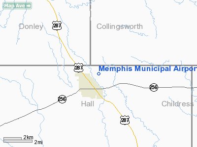
| Memphis Municipal Airport |
| IATA: none – ICAO: none – FAA LID: F21 |
| Summary |
| Airport type |
Public |
| Owner |
City of Memphis, Texas |
| Serves |
Memphis, Texas |
| Elevation AMSL |
2,102 ft / 641 m |
| Coordinates |
34°44′23″N 100°31′47″W / 34.73972°N 100.52972°W / 34.73972; -100.52972 |
| Runways |
| Direction |
Length |
Surface |
| ft |
m |
| 8/26 |
2,750 |
838 |
Turf |
| 17/35 |
4,670 |
1,423 |
Asphalt |
| Statistics (2007) |
| Aircraft operations |
2,300 |
| Source: Federal Aviation Administration |
Memphis Municipal Airport (FAA LID: F21) is a city-owned public use airport located one nautical mile (1.85 km) northeast of the central business district of Memphis, a city in Hall County, Texas, United States.
Facilities and aircraft
Memphis Municipal Airport covers an area of 231 acres (93 ha) at an elevation of 2,102 feet (641 m) above mean sea level. It has two runways: 17/35 is 4,670 by 75 feet (1,423 x 23 m) with an asphalt pavement and 8/26 is 2,750 by 70 feet (838 x 21 m) with a turf surface. For the 12-month period ending April 1, 2007, the airport had 2,300 general aviation aircraft operations, an average of 191 per month.
The above content comes from Wikipedia and is published under free licenses – click here to read more.
Location & QuickFacts
| FAA Information Effective: | 2008-09-25 |
| Airport Identifier: | F21 |
| Airport Status: | Operational |
| Longitude/Latitude: | 100-31-46.9230W/34-44-22.5220N
-100.529701/34.739589 (Estimated) |
| Elevation: | 2102 ft / 640.69 m (Estimated) |
| Land: | 231 acres |
| From nearest city: | 1 nautical miles NE of Memphis, TX |
| Location: | Hall County, TX |
| Magnetic Variation: | 08E (1985) |
Owner & Manager
| Ownership: | Publicly owned |
| Owner: | City Of Memphis |
| Address: | 721 Robertson St
Memphis, TX 79245 |
| Phone number: | 806-259-3001 |
| Manager: | Kirby Gardenhire
DIRECTOR OF PUBLIC WORKS OR CITY SECRETARY. |
| Address: | 721 Robertson St
Memphis, TX 79245 |
| Phone number: | 806-259-3001 |
Airport Operations and Facilities
| Airport Use: | Open to public |
| Wind indicator: | Yes |
| Segmented Circle: | Yes |
| Control Tower: | No |
| Lighting Schedule: | DUSK-DAWN
ACTVT MIRL RY 17/35 - CTAF. |
| Beacon Color: | Clear-Green (lighted land airport) |
| Landing fee charge: | No |
| Sectional chart: | Dallas-ft Worth |
| Region: | ASW - Southwest |
| Boundary ARTCC: | ZAB - Albuquerque |
| Tie-in FSS: | FTW - Fort Worth |
| FSS on Airport: | No |
| FSS Phone: | 817-541-3474 |
| FSS Toll Free: | 1-800-WX-BRIEF |
| NOTAMs Facility: | FTW (NOTAM-d service avaliable) |
| Federal Agreements: | NGY |
Airport Communications
Airport Services
| Airframe Repair: | NONE |
| Power Plant Repair: | NONE |
| Bottled Oxygen: | NONE |
| Bulk Oxygen: | NONE |
Runway Information
Runway 08/26
| Dimension: | 2750 x 70 ft / 838.2 x 21.3 m |
| Surface: | TURF, Fair Condition |
| |
Runway 08 |
Runway 26 |
| Longitude: | 100-31-56.0000W | 100-31-23.0500W |
| Latitude: | 34-44-09.0000N | 34-44-09.0000N |
| Alignment: | 90 | 127 |
| Traffic Pattern: | Left | Left |
| Obstruction: | 8 ft road, 90.0 ft from runway, 11:1 slope to clear | 28 ft pline, 250.0 ft from runway, 8:1 slope to clear |
|
Runway 17/35
| Dimension: | 4670 x 75 ft / 1423.4 x 22.9 m |
| Surface: | ASPH, Good Condition |
| Weight Limit: | Single wheel: 10000 lbs. |
| Edge Lights: | Medium |
| |
Runway 17 |
Runway 35 |
| Longitude: | 100-31-50.9900W | 100-31-51.5700W |
| Latitude: | 34-44-53.5800N | 34-44-07.3900N |
| Elevation: | 2102.00 ft | 2070.00 ft |
| Alignment: | 127 | 1 |
| Traffic Pattern: | Left | Left |
| Markings: | Non-precision instrument, Fair Condition | Non-precision instrument, Fair Condition |
| Obstruction: | , 50:1 slope to clear | 18 ft trees, 747.0 ft from runway, 30:1 slope to clear |
|
Radio Navigation Aids
| ID |
Type |
Name |
Ch |
Freq |
Var |
Dist |
| CDS | VORTAC | Childress | 123X | 117.60 | 10E | 25.3 nm |
Images and information placed above are from
http://www.airport-data.com/airport/F21/
We thank them for the data!
| General Info
|
| Country |
United States
|
| State |
TEXAS
|
| FAA ID |
F21
|
| Latitude |
34-44-22.522N
|
| Longitude |
100-31-46.923W
|
| Elevation |
2102 feet
|
| Near City |
MEMPHIS
|
We don't guarantee the information is fresh and accurate. The data may
be wrong or outdated.
For more up-to-date information please refer to other sources.
|
|


