 |
|
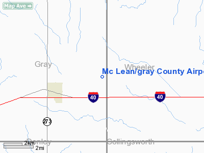
Mc Lean/gray County Airport |
Location & QuickFacts
| FAA Information Effective: | 2008-09-25 |
| Airport Identifier: | 2E7 |
| Airport Status: | Operational |
| Longitude/Latitude: | 100-32-38.4720W/35-14-49.1780N
-100.544020/35.246994 (Estimated) |
| Elevation: | 2835 ft / 864.11 m (Estimated) |
| Land: | 250 acres |
| From nearest city: | 3 nautical miles E of Mc Lean, TX |
| Location: | Gray County, TX |
| Magnetic Variation: | 08E (1985) |
Owner & Manager
| Ownership: | Publicly owned |
| Owner: | Gray County |
| Address: | Gray Co Courthouse
Pampa, TX 79057 |
| Phone number: | 806-669-8007 |
| Manager: | James Hefley
COUNTY COMMISSIONER. |
| Address: | Po Box 42
Mclean, TX 79057 |
| Phone number: | 806-779-2493
OR 806-779-3134. |
Airport Operations and Facilities
| Airport Use: | Open to public |
| Wind indicator: | Yes |
| Segmented Circle: | Yes |
| Control Tower: | No |
| Lighting Schedule: | DUSK-DAWN |
| Beacon Color: | Clear-Green (lighted land airport)
ROTG BCN OTS INDEFLY. |
| Landing fee charge: | No |
| Sectional chart: | Dallas-ft Worth |
| Region: | ASW - Southwest |
| Boundary ARTCC: | ZAB - Albuquerque |
| Tie-in FSS: | FTW - Fort Worth |
| FSS on Airport: | No |
| FSS Phone: | 817-541-3474 |
| FSS Toll Free: | 1-800-WX-BRIEF |
| NOTAMs Facility: | FTW (NOTAM-d service avaliable) |
| Federal Agreements: | SX |
Airport Communications
Airport Services
| Airframe Repair: | NONE |
| Power Plant Repair: | NONE |
| Bottled Oxygen: | NONE |
| Bulk Oxygen: | NONE |
Runway Information
Runway 17/35
| Dimension: | 3225 x 50 ft / 983.0 x 15.2 m |
| Surface: | ASPH, |
| Weight Limit: | Single wheel: 12500 lbs. |
| Edge Lights: | Non-standard lighting system
NSTD FRUIT JAR LGTS ON NON-FRANGIBLE METAL CONDUIT. |
| |
Runway 17 |
Runway 35 |
| Traffic Pattern: | Left | Left |
| Markings: | Basic, Good Condition | Basic, Good Condition |
| Obstruction: | , 50:1 slope to clear | 10 ft road, 464.0 ft from runway, 26:1 slope to clear |
|
Radio Navigation Aids
| ID |
Type |
Name |
Ch |
Freq |
Var |
Dist |
| PPA | NDB | Pampa | | 368.00 | 09E | 31.1 nm |
| HHF | NDB | Hemphill County | | 400.00 | 08E | 39.3 nm |
| SYO | VORTAC | Sayre | 099X | 115.20 | 10E | 45.0 nm |
Remarks
- RY 17/35 TRANSITIONAL SURFACE OBSTRUCT BY +35 FT TREES WEST AND EAST OF RY CNTRLN.
- WILDLIFE ON AND IN VICINITY OF AIRPORT.
- NO LINE OF SIGHT BTN RY ENDS.
Images and information placed above are from
http://www.airport-data.com/airport/2E7/
We thank them for the data!
| General Info
|
| Country |
United States
|
| State |
TEXAS
|
| FAA ID |
2E7
|
| Latitude |
35-14-49.178N
|
| Longitude |
100-32-38.472W
|
| Elevation |
2835 feet
|
| Near City |
MC LEAN
|
We don't guarantee the information is fresh and accurate. The data may
be wrong or outdated.
For more up-to-date information please refer to other sources.
|
|


