 |
|
Maverick County Memorial Intl Airport |
| Maverick County Memorial International Airport |
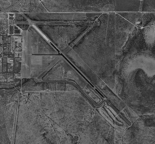 |
| USGS aerial photo, 20 February 2002 |
| IATA: EGP – ICAO: none – FAA LID: 5T9 |
| Summary |
| Airport type |
Public |
| Owner |
County of Maverick |
| Serves |
Eagle Pass, Texas |
| Location |
Radar Base, Maverick County, near Eagle Pass, Texas |
| Elevation AMSL |
887 ft / 270 m |
| Coordinates |
28°51′26″N 100°30′48″W / 28.85722°N 100.51333°W / 28.85722; -100.51333 |
| Runways |
| Direction |
Length |
Surface |
| ft |
m |
| 13/31 |
5,506 |
1,678 |
Asphalt |
| Statistics (2008) |
| Aircraft operations |
600 |
| Based aircraft |
2 |
| Source: Federal Aviation Administration |
Maverick County Memorial International Airport (IATA: EGP, FAA LID: 5T9) is a county-owned public use airport in Maverick County, Texas, United States. It is located eight nautical miles (15 km) north of the central business district of Eagle Pass, Texas. History
The airport was opened in July 1943 as Eagle Pass Army Airfield and was used by the United States Army Air Forces as an advanced single engine flying school. In November 1944, the training at the base was changed to a basic flying school. All flight training at the field was discontinued in April 1945, with the airfield being determined to be excess by the military and turned over to the local government for civil use.
Eagle Pass Air Force Station was built in the 1950s on the former Eagle Pass AAF cantonment area. It was a long-range radar site. The 733rd AC&W Squadron began operating an AN/FPS-20A search radar and an AN/FPS-6 height-finder radar at this site in 1959. Eagle Pass AFS ceased operations in 1963. The airfield was abandoned and the Air Force housing was turned over to Maverick county.
Eagle Pass airfield was reopened under the name of "Laughlin AF Aux #1" in 1962 for touch & go landings by T-37 training aircraft based at Laughlin AFB. In 1991 a replacement airfield was built in nearby Spofford, and Eagle Pass was closed.
At some point between 1991–94, after the closure of this field by the Air Force, it was apparently operated as a private airfield, named "Bowles".
Facilities and aircraft
Maverick County Memorial International Airport has one asphalt paved runway designated 13/31 which measures 5,506 by 100 feet (1,678 x 30 m). For the 12-month period ending July 28, 2008, the airport had 600 general aviation aircraft operations, an average of 50 per month.
The above content comes from Wikipedia and is published under free licenses – click here to read more.

Location & QuickFacts
| FAA Information Effective: | 2008-09-25 |
| Airport Identifier: | 5T9 |
| Airport Status: | Operational |
| Longitude/Latitude: | 100-30-48.4840W/28-51-25.5340N
-100.513468/28.857093 (Estimated) |
| Elevation: | 887 ft / 270.36 m (Estimated) |
| Land: | 0 acres |
| From nearest city: | 8 nautical miles N of Eagle Pass, TX |
| Location: | Maverick County, TX |
| Magnetic Variation: | 08E (1985) |
Owner & Manager
| Ownership: | Publicly owned |
| Owner: | County Of Maverick |
| Address: | 500 Quarry
Eagle Pass, TX 78852 |
| Phone number: | 830-773-3824 |
| Manager: | Jose Aranda, Jr.
COUNTY JUDGE. |
| Address: | 500 Quarry Street, Suite 3
Eagle Pass, TX 78852 |
| Phone number: | 830-773-3824 |
Airport Operations and Facilities
| Airport Use: | Open to public |
| Wind indicator: | Yes |
| Segmented Circle: | Yes |
| Control Tower: | No |
| Lighting Schedule: | DUSK-DAWN
MIRL RY 13/31 PRESET LOW INTST; TO INCR INTST ACTVT - CTAF. |
| Sectional chart: | San Antonio |
| Region: | ASW - Southwest |
| Boundary ARTCC: | ZHU - Houston |
| Tie-in FSS: | SJT - San Angelo |
| FSS on Airport: | No |
| FSS Toll Free: | 1-800-WX-BRIEF |
| NOTAMs Facility: | SJT (NOTAM-d service avaliable) |
| Federal Agreements: | NP |
Airport Communications
| CTAF: | 122.800 |
| Unicom: | 122.800 |
Airport Services
| Fuel available: | 100LLA |
| Airframe Repair: | NONE |
| Power Plant Repair: | NONE |
| Bottled Oxygen: | NONE |
| Bulk Oxygen: | NONE |
Runway Information
Runway 13/31
| Dimension: | 5506 x 100 ft / 1678.2 x 30.5 m |
| Surface: | ASPH, Fair Condition |
| Edge Lights: | Medium |
| |
Runway 13 |
Runway 31 |
| Longitude: | 100-31-10.3800W | 100-30-26.5880W |
| Latitude: | 28-51-44.8020N | 28-51-06.2660N |
| Elevation: | 887.00 ft | 882.00 ft |
| Traffic Pattern: | Left | Left |
| Markings: | Non-precision instrument, Good Condition | Non-precision instrument, Good Condition |
| Obstruction: | 8 ft brush, 240.0 ft from runway, 200 ft left of centerline, 5:1 slope to clear
5-10 FT BRUSH 0-200 FT FM THLD 175-250 FT LEFT. | 10 ft brush, 210.0 ft from runway, 80 ft right of centerline, 1:1 slope to clear
5-15 FT BRUSH 0-200 FT FM THLD 70-125 FT RIGHT. |
|
Radio Navigation Aids
| ID |
Type |
Name |
Ch |
Freq |
Var |
Dist |
| PFO | NDB | Spofford | | 356.00 | 08E | 17.9 nm |
| BRX | NDB | La Fonda Ranch | | 269.00 | 09E | 21.9 nm |
| CPZ | NDB | Chaparrosa Ranch | | 385.00 | 10E | 26.9 nm |
| LKX | NDB | La Pryor | | 223.00 | 09E | 34.9 nm |
| DMD | NDB | Dimmit County | | 343.00 | 07E | 41.4 nm |
| UVA | NDB | Uvalde | | 281.00 | 07E | 45.7 nm |
| DLF | VORTAC | Laughlin | 091X | 114.40 | 07E | 33.2 nm |
Remarks
- FLIGHT NOTIFICATION SERVICE (ADCUS) AVBL.
Images and information placed above are from
http://www.airport-data.com/airport/5T9/
We thank them for the data!
| General Info
|
| Country |
United States
|
| State |
TEXAS
|
| FAA ID |
5T9
|
| Latitude |
28-51-25.897N
|
| Longitude |
100-30-44.279W
|
| Elevation |
878 feet
|
| Near City |
EAGLE PASS
|
We don't guarantee the information is fresh and accurate. The data may
be wrong or outdated.
For more up-to-date information please refer to other sources.
|
|


