 |
|
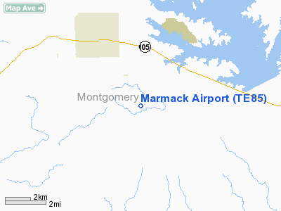
Location & QuickFacts
| FAA Information Effective: | 2008-09-25 |
| Airport Identifier: | TE85 |
| Airport Status: | Operational |
| Longitude/Latitude: | 095-39-40.7700W/30-20-31.9600N
-95.661325/30.342211 (Estimated) |
| Elevation: | 295 ft / 89.92 m (Estimated) |
| Land: | 50 acres |
| From nearest city: | 5 nautical miles NW of Montgomery, TX |
| Location: | Montgomery County, TX |
| Magnetic Variation: | 05E (1995) |
Owner & Manager
| Ownership: | Privately owned |
| Owner: | Jam Holdings, Ltd |
| Address: | 14655 Champion Forest #1002
Houston, TX 77069 |
| Phone number: | 713-822-4476 |
| Manager: | Jeff Marmack |
| Address: | 14655 Champion Forest #1002
Houston, TX 77069 |
| Phone number: | 713-822-4476 |
Airport Operations and Facilities
| Airport Use: | Private |
| Wind indicator: | Yes |
| Segmented Circle: | No |
| Control Tower: | No |
| Lighting Schedule: | RDO-CTL
ACTVT LIRL RY 12/30 - 122.6. |
| Sectional chart: | Houston |
| Region: | ASW - Southwest |
| Boundary ARTCC: | ZHU - Houston |
| Tie-in FSS: | CXO - Montgomery County |
| FSS Toll Free: | 1-800-WX-BRIEF |
Runway Information
Runway 12/30
| Dimension: | 2100 x 16 ft / 640.1 x 4.9 m |
| Surface: | ASPH, |
| Edge Lights: | Low |
| |
Runway 12 |
Runway 30 |
| Traffic Pattern: | Left | Left |
| Obstruction: | | 100 ft trees, 200.0 ft from runway |
|
Radio Navigation Aids
| ID |
Type |
Name |
Ch |
Freq |
Var |
Dist |
| DWH | NDB | David Hooks | | 521.00 | 05E | 13.9 nm |
| UTS | NDB | Huntsville | | 308.00 | 06E | 24.2 nm |
| EYQ | NDB | Weiser | | 286.00 | 06E | 24.6 nm |
| BVP | NDB | Nixin | | 326.00 | 05E | 31.3 nm |
| LYD | NDB | Lakeside | | 249.00 | 05E | 31.6 nm |
| BNH | NDB | Brenham | | 362.00 | 06E | 37.7 nm |
| SGR | NDB | Hull | | 388.00 | 05E | 42.7 nm |
| HUB | VOR/DME | Hobby | 118X | 117.10 | 05E | 45.9 nm |
| TNV | VORTAC | Navasota | 106X | 115.90 | 08E | 20.8 nm |
| IAH | VORTAC | Humble | 113X | 116.60 | 05E | 28.4 nm |
| CLL | VORTAC | College Station | 080X | 113.30 | 08E | 42.4 nm |
| LOA | VORTAC | Leona | 045X | 110.80 | 08E | 49.6 nm |
| HOU | VOT | Houston Wm P Hobby | | 108.40 | | 46.4 nm |
Remarks
- CATTLE AND DEER ON & INVOF ARPT.
Images and information placed above are from
http://www.airport-data.com/airport/TE85/
We thank them for the data!
| General Info
|
| Country |
United States
|
| State |
TEXAS
|
| FAA ID |
TE85
|
| Latitude |
30-20-31.960N
|
| Longitude |
095-39-40.770W
|
| Elevation |
295 feet
|
| Near City |
MONTGOMERY
|
We don't guarantee the information is fresh and accurate. The data may
be wrong or outdated.
For more up-to-date information please refer to other sources.
|
|


