 |
|
Location & QuickFacts
| FAA Information Effective: | 2008-09-25 |
| Airport Identifier: | XS48 |
| Airport Status: | Operational |
| Longitude/Latitude: | 095-34-39.0000W/32-57-14.0000N
-95.577500/32.953889 (Estimated) |
| Elevation: | 490 ft / 149.35 m (Estimated) |
| Land: | 0 acres |
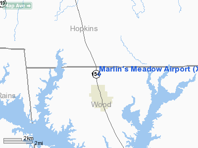
| From nearest city: | 2 nautical miles N of Yantis, TX |
| Location: | Wood County, TX |
| Magnetic Variation: | () |
Owner & Manager
| Ownership: | Privately owned |
| Owner: | Ben M. Scarborough |
| Address: | 5944 W. State Hwy 154
Yantis, TX 75497 |
| Phone number: | 903-383-2373 |
| Manager: | Ben M. Scarborough |
| Address: | 5944 W. State Hwy 154
Yantis, TX 75497 |
| Phone number: | 903-383-2373 |
Airport Operations and Facilities
| Airport Use: | Private |
| Control Tower: | No |
| Sectional chart: | Dallas-ft Worth |
| Region: | ASW - Southwest |
| Boundary ARTCC: | ZFW - Fort Worth |
| Tie-in FSS: | FTW - Fort Worth |
| FSS Phone: | 817-541-3474 |
| FSS Toll Free: | 1-800-WX-BRIEF |
Runway Information
Runway 03/21
| Dimension: | 2840 x 40 ft / 865.6 x 12.2 m |
| Surface: | TURF, |
| |
Runway 03 |
Runway 21 |
| Traffic Pattern: | Left | Left |
| Obstruction: | 30 ft pline | 40 ft trees, 200.0 ft from runway |
|
Radio Navigation Aids
| ID |
Type |
Name |
Ch |
Freq |
Var |
Dist |
| SYW | NDB | Cash | | 428.00 | 05E | 24.8 nm |
| ABG | NDB | Ambassador | | 404.00 | 07E | 32.3 nm |
| TY | NDB | Tyler | | 320.00 | 06E | 32.8 nm |
| MII | NDB | Caddo Mills | | 316.00 | 06E | 34.2 nm |
| AVZ | NDB | Travis | | 260.00 | 06E | 35.9 nm |
| LST | NDB | Lone Star | | 305.00 | 05E | 42.1 nm |
| PQF | NDB | Mesquite | | 248.00 | 06E | 48.8 nm |
| AHX | NDB | Athens | | 269.00 | 06E | 49.4 nm |
| HJM | NDB | Rayburn | | 415.00 | 06E | 49.8 nm |
| MJF | TACAN | Arvilla | 033X | | 05E | 25.3 nm |
| UIM | VOR/DME | Quitman | 087X | 114.00 | 08E | 11.5 nm |
| SLR | VOR/DME | Sulphur Springs | 027X | 109.00 | 08E | 14.8 nm |
| PRX | VOR/DME | Paris | 083X | 113.60 | 07E | 36.0 nm |
| TYR | VOR/DME | Tyler | 089X | 114.20 | 06E | 37.0 nm |
| BYP | VORTAC | Bonham | 093X | 114.60 | 06E | 48.2 nm |
Remarks
- 390 FT TWR 3000 FT SE OF ARPT.
- PRVDD VFR OPNS, CLEAR 20:1 APCHS AND OPERATORAMENDSOPNS TO ACCOUNT FOR 390 FT CELL TWR 3000 FT SE OF ARPT.
Images and information placed above are from
http://www.airport-data.com/airport/XS48/
We thank them for the data!
| General Info
|
| Country |
United States
|
| State |
TEXAS
|
| FAA ID |
XS48
|
| Latitude |
31-16-38.660N
|
| Longitude |
094-59-22.764W
|
| Elevation |
290 feet
|
| Near City |
APPLESPRINGS
|
We don't guarantee the information is fresh and accurate. The data may
be wrong or outdated.
For more up-to-date information please refer to other sources.
|
|


