 |
|
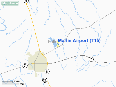
Location & QuickFacts
| FAA Information Effective: | 2008-09-25 |
| Airport Identifier: | T15 |
| Airport Status: | Operational |
| Longitude/Latitude: | 096-51-07.3000W/31-20-26.4000N
-96.852028/31.340667 (Estimated) |
| Elevation: | 411 ft / 125.27 m (Surveyed) |
| Land: | 38 acres |
| From nearest city: | 3 nautical miles NE of Marlin, TX |
| Location: | Falls County, TX |
| Magnetic Variation: | 05E (2000) |
Owner & Manager
| Ownership: | Publicly owned |
| Owner: | City Of Marlin & Texas Ng |
| Address: | Po Box 980
Marlin, TX 76661 |
| Phone number: | 254-883-1450 |
| Manager: | Randall E. Holly
CITY MANAGER. |
| Address: | Po Box 980
Marlin, TX 76661 |
| Phone number: | 254-883-1450 |
Airport Operations and Facilities
| Airport Use: | Open to public |
| Wind indicator: | Yes |
| Segmented Circle: | Yes |
| Control Tower: | No |
| Lighting Schedule: | DUSK-DAWN |
| Beacon Color: | Clear-Green (lighted land airport) |
| Landing fee charge: | No |
| Sectional chart: | Houston |
| Region: | ASW - Southwest |
| Boundary ARTCC: | ZFW - Fort Worth |
| Tie-in FSS: | FTW - Fort Worth |
| FSS on Airport: | No |
| FSS Phone: | 817-541-3474 |
| FSS Toll Free: | 1-800-WX-BRIEF |
| NOTAMs Facility: | FTW (NOTAM-d service avaliable) |
Airport Communications
Airport Services
| Airframe Repair: | NONE |
| Power Plant Repair: | NONE |
| Bottled Oxygen: | NONE |
| Bulk Oxygen: | NONE |
Runway Information
Runway 17/35
| Dimension: | 3021 x 50 ft / 920.8 x 15.2 m |
| Surface: | ASPH, Good Condition |
| Weight Limit: | Single wheel: 4000 lbs. |
| Edge Lights: | Non-standard lighting system
NSTD LIRL; NORTH 2900 FT LGTD. |
| |
Runway 17 |
Runway 35 |
| Longitude: | 096-51-07.0051W | 096-51-07.6793W |
| Latitude: | 31-20-41.3894N | 31-20-11.4972N |
| Elevation: | 410.00 ft | 402.00 ft |
| Alignment: | 127 | 1 |
| Traffic Pattern: | Left | Left |
| Markings: | Basic, Fair Condition | Basic, Fair Condition |
| Displaced threshold: | 0.00 ft | 90.00 ft |
| Obstruction: | 45 ft tree, 993.0 ft from runway, 138 ft right of centerline, 17:1 slope to clear | 17 ft bldg, 306.0 ft from runway, 110 ft right of centerline, 5:1 slope to clear
APCH RATIO 10:1 TO DSPLCD THLD +8 FT FENCE 80 FT FM DSPLCD THLD 82 FT RIGHT OF CNTRLN.
+8 FT FENCE 82 FT RIGHT & 80 FT SOUTH OF DSPLCD THLD. |
|
Radio Navigation Aids
| ID |
Type |
Name |
Ch |
Freq |
Var |
Dist |
| ROB | NDB | Robinson | | 400.00 | 07E | 14.9 nm |
| LXY | NDB | Mexia | | 329.00 | 07E | 25.0 nm |
| PYF | NDB | Pyramid | | 418.00 | 06E | 45.9 nm |
| HLR | NDB | Hood | | 347.00 | 07E | 46.0 nm |
| CRS | NDB | Corsicana | | 396.00 | 06E | 47.4 nm |
| IL | NDB | Iresh | | 278.00 | 07E | 48.0 nm |
| CGQ | NDB | Powell | | 344.00 | 06E | 48.6 nm |
| GNL | VOR/DME | Groesbeck | 025X | 108.80 | 05E | 21.2 nm |
| TPL | VOR/DME | Temple | 041X | 110.40 | 09E | 30.5 nm |
| ACT | VORTAC | Waco | 100X | 115.30 | 09E | 28.8 nm |
| LOA | VORTAC | Leona | 045X | 110.80 | 08E | 47.3 nm |
| CLL | VORTAC | College Station | 080X | 113.30 | 08E | 49.5 nm |
Remarks
Images and information placed above are from
http://www.airport-data.com/airport/T15/
We thank them for the data!
| General Info
|
| Country |
United States
|
| State |
TEXAS
|
| FAA ID |
T15
|
| Latitude |
31-20-26.400N
|
| Longitude |
096-51-07.300W
|
| Elevation |
411 feet
|
| Near City |
MARLIN
|
We don't guarantee the information is fresh and accurate. The data may
be wrong or outdated.
For more up-to-date information please refer to other sources.
|
|


