 |
|
| Marfa Municipal Airport |
| IATA: MRF – ICAO: KMRF – FAA LID: MRF |
| Summary |
| Airport type |
Public |
| Owner |
Presidio County |
| Serves |
Marfa, Texas |
| Elevation AMSL |
4,849 ft / 1,478 m |
| Coordinates |
30°22′16″N 104°01′03″W / 30.37111°N 104.0175°W / 30.37111; -104.0175 |
| Runways |
| Direction |
Length |
Surface |
| ft |
m |
| 12/30 |
6,214 |
1,894 |
Asphalt |
| 3/21 |
5,307 |
1,618 |
Asphalt |
| 8/26 |
2,825 |
861 |
Dirt |
| Statistics (2007) |
| Aircraft operations |
15,000 |
| Based aircraft |
18 |
| Sources: FAA, Texas DOT |
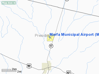
Marfa Municipal Airport (IATA: MRF, ICAO: KMRF, FAA LID: MRF) is a county-owned public-use airport located three nautical miles (6 km) north of the central business district of Marfa, a city in Presidio County, Texas, United States. The airport serves private aircraft and has no scheduled airlines service. Facilities and aircraft
Marfa Municipal Airport covers an area of 816 acres (330 ha) at an elevation of 4,849 feet (1,478 m) above mean sea level. It has two asphalt paved runways: 12/30 is 6,214 by 75 feet (1,894 x 23 m) and 3/21 is 5,307 by 75 feet (1,618 x 23 m). It also has a third runway with a dirt surface: 8/26 is 2,825 by 60 feet (861 x 18 m).
For the 12-month period ending April 23, 2007, the airport had 15,000 aircraft operations, an average of 41 per day, all of which were general aviation. At that time there were 18 aircraft based at this airport: 61% single-engine, 6% multi-engine and 33% glider.
Gliders
In April 2008, the Marfa Airport was recognized as the 15th National Landmark of Soaring by the National Soaring Museum.
Marfa Gliders offers sailplane flight training and glider rides throughout the year and hosts a soaring camp in spring.
The above content comes from Wikipedia and is published under free licenses – click here to read more.
Location & QuickFacts
| FAA Information Effective: | 2008-09-25 |
| Airport Identifier: | MRF |
| Airport Status: | Operational |
| Longitude/Latitude: | 104-01-03.3110W/30-22-15.9700N
-104.017586/30.371103 (Estimated) |
| Elevation: | 4849 ft / 1477.98 m (Surveyed) |
| Land: | 816 acres |
| From nearest city: | 3 nautical miles N of Marfa, TX |
| Location: | Presidio County, TX |
| Magnetic Variation: | 10E (1985) |
Owner & Manager
| Ownership: | Publicly owned |
| Owner: | Presidio County |
| Address: | Box 691
Marfa, TX 79843 |
| Phone number: | 432-729-4452 |
| Manager: | Danny Watts
COUNTY COMMISSIONER. |
| Address: | Po Box 606
Marfa, TX 79843 |
| Phone number: | 432-295-0147
AFT HRS PHONE NUMBER 432-729-3102. |
Airport Operations and Facilities
| Airport Use: | Open to public |
| Wind indicator: | Yes |
| Segmented Circle: | Yes |
| Control Tower: | No |
| Lighting Schedule: | DUSK-DAWN
MIRL RY 12/30 PRESET LOW INTST; TO INCR INTST ACTVT - CTAF. |
| Beacon Color: | Clear-Green (lighted land airport) |
| Landing fee charge: | Yes
LANDING FEE FOR ACFT WITH MAX GROSS WEIGHT OF 40,000 LBS & OVER. |
| Sectional chart: | El Paso |
| Region: | ASW - Southwest |
| Boundary ARTCC: | ZAB - Albuquerque |
| Tie-in FSS: | SJT - San Angelo |
| FSS on Airport: | No |
| FSS Toll Free: | 1-800-WX-BRIEF |
| NOTAMs Facility: | MRF (NOTAM-d service avaliable) |
| Federal Agreements: | NGY3 |
Airport Communications
| CTAF: | 122.800 |
| Unicom: | 122.800 |
Airport Services
| Fuel available: | 100LLA |
| Airframe Repair: | MAJOR |
| Power Plant Repair: | MAJOR |
| Bottled Oxygen: | NONE |
| Bulk Oxygen: | NONE |
Runway Information
Runway 03/21
| Dimension: | 5307 x 75 ft / 1617.6 x 22.9 m |
| Surface: | ASPH,
ROUGH. |
| Weight Limit: | Single wheel: 38000 lbs. |
| |
Runway 03 |
Runway 21 |
| Longitude: | 104-01-13.6400W | 104-00-30.5800W |
| Latitude: | 30-21-56.5500N | 30-22-33.5000N |
| Elevation: | 4827.00 ft | 4849.00 ft |
| Alignment: | 45 | 127 |
| Traffic Pattern: | Left | Left |
| Markings: | Basic, Good Condition | Basic, Good Condition |
| Obstruction: | 4 ft brush, 250.0 ft from runway, 150 ft left of centerline, 12:1 slope to clear | , 50:1 slope to clear |
|
Runway 08/26
| Dimension: | 2825 x 60 ft / 861.1 x 18.3 m |
| Surface: | DIRT, Poor Condition
ROUGH. |
| |
Runway 08 |
Runway 26 |
| Longitude: | 104-01-32.6590W | 104-01-00.6580W |
| Latitude: | 30-22-10.5720N | 30-22-10.5730N |
| Elevation: | 4825.00 ft | 4836.00 ft |
| Traffic Pattern: | Left | Left |
| Obstruction: | 5 ft fence, 132.0 ft from runway, 26:1 slope to clear | , 50:1 slope to clear |
|
Runway 12/30
| Dimension: | 6214 x 75 ft / 1894.0 x 22.9 m |
| Surface: | ASPH, Good Condition
ROUGH. |
| Weight Limit: | Single wheel: 38000 lbs. |
| Edge Lights: | Medium |
| |
Runway 12 |
Runway 30 |
| Longitude: | 104-01-31.7900W | 104-00-41.9220W |
| Latitude: | 30-22-41.0740N | 30-21-57.3530N |
| Elevation: | 4840.00 ft | 4830.00 ft |
| Alignment: | 127 | 127 |
| Traffic Pattern: | Left | Left |
| Markings: | Non-precision instrument, Good Condition | Non-precision instrument, Good Condition |
| VASI: | pulsating/steady burning on left side | pulsating/steady burning on left side |
|
Radio Navigation Aids
| ID |
Type |
Name |
Ch |
Freq |
Var |
Dist |
| BWR | NDB | Brewster County | | 412.00 | 09E | 19.9 nm |
| IMP | NDB | Marathon | | 388.00 | 10E | 41.0 nm |
| MRF | VOR/DME | Marfa | 106X | 115.90 | 11E | 5.5 nm |
Remarks
- 104 FT AGL UNLGTD WATER TOWER 1800 FT S OF AER 30.
- GLIDER OPNS ON & INVOF ARPT.
Images and information placed above are from
http://www.airport-data.com/airport/MRF/
We thank them for the data!
| General Info
|
| Country |
United States
|
| State |
TEXAS
|
| FAA ID |
MRF
|
| Latitude |
30-22-17.300N
|
| Longitude |
104-01-00.100W
|
| Elevation |
4849 feet
|
| Near City |
MARFA
|
We don't guarantee the information is fresh and accurate. The data may
be wrong or outdated.
For more up-to-date information please refer to other sources.
|
|


