|
|
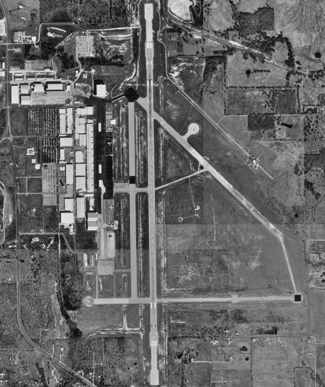
| Majors Airport |
 |
| USGS aerial image - 21 February 1995 |
| IATA: GVT – ICAO: KGVT – FAA LID: GVT |
| Summary |
| Airport type |
Public |
| Owner |
City of Greenville |
| Serves |
Greenville, Texas |
| Elevation AMSL |
535 ft / 163 m |
| Coordinates |
33°04′04″N 096°03′55″W / 33.06778°N 96.06528°W / 33.06778; -96.06528Coordinates: 33°04′04″N 096°03′55″W / 33.06778°N 96.06528°W / 33.06778; -96.06528 |
| Runways |
| Direction |
Length |
Surface |
| ft |
m |
| 17/35 |
8,030 |
2,448 |
Asphalt |
| Statistics (2007) |
| Aircraft operations |
35,640 |
| Based aircraft |
39 |
| Source: Federal Aviation Administration |
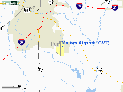
Majors Airport (IATA: GVT, ICAO: KGVT, FAA LID: GVT) is a city-owned, public-use airport located four nautical miles (7 km) southeast of the central business district of Greenville, a city in Hunt County, Texas, United States.
Originally named Majors Field, is mostly used for general aviation, but is also home to an L-3 Communications facility that is used to modify aircraft. History
Majors Airport, named for Lieutenant Truett Majors, the first Hunt County native to perish in World War II, began operations on June 26, 1942, as a training center for the United States Army Air Forces. Lt Majors was killed in the 1942 Battle of the Philippines in January 1942. Greenville was chosen as a site for the USAAF basic flight-training center due to the efforts of the influential politician Sam Rayburn, the base was formally dedicated and named on 5 January 1943.
Majors Army Airfield was assigned initially to the Gulf Coast Training Center (later Central Flying Command), the airport was at one point the home to approximately 5,000 pilots, support personnel, and civilian employees. Majors also was a major training base for Women Airforce Service Pilots (WASP)s. Flying training was performed with Fairchild PT-19s as the primary trainer. Also had several PT-17 Stearmans and a few P-40 Warhawks assigned.
In addition to training United States Army pilots, the airfield was the training site for Escuadrón 201 of the Mexican Air Force. The training center was reassigned to Second Air Force on 30 November 1944 as a group training center, primary for the assignment of replacement personnel to combat squadrons in Overseas theaters.
Majors AAF was inactivated on 18 July 1945 after the defeat of Germany; the city of Greenville then took ownership of the property, then leased the site to TEMCO (later L-3 Communications).
Facilities and aircraft
Majors Airport covers an area of 1,525 acres (617 ha) at an elevation of 535 feet (163 m) above mean sea level. It has one runway designated 17/35 with an asphalt surface measuring 8,030 by 150 feet (2,448 x 46 m).
For the 12-month period ending April 30, 2007, the airport had 35,640 aircraft operations, an average of 97 per day: 92% general aviation and 8% military. At that time there were 39 aircraft based at this airport: 90% single-engine and 10% multi-engine.
The above content comes from Wikipedia and is published under free licenses – click here to read more.
Location & QuickFacts
| FAA Information Effective: | 2008-09-25 |
| Airport Identifier: | GVT |
| Airport Status: | Operational |
| Longitude/Latitude: | 096-03-55.1970W/33-04-04.2200N
-96.065332/33.067839 (Estimated) |
| Elevation: | 535 ft / 163.07 m (Surveyed) |
| Land: | 1525 acres |
| From nearest city: | 4 nautical miles SE of Greenville, TX |
| Location: | Hunt County, TX |
| Magnetic Variation: | 05E (1995) |
Owner & Manager
| Ownership: | Publicly owned |
| Owner: | City Of Greenville |
| Address: | 2821 Washington Street
Greenville, TX 75401 |
| Phone number: | 903-457-3100 |
| Manager: | Lori Philyaw
ACTING AIRPORT MANAGER. |
| Address: | Greenville Municipal Airport
Greenville, TX 75401 |
| Phone number: | 903-457-3168 |
Airport Operations and Facilities
| Airport Use: | Open to public |
| Wind indicator: | Yes |
| Segmented Circle: | Yes |
| Control Tower: | Yes |
| Lighting Schedule: | DUSK-DAWN
ACTVT MALS RY 17 - CTAF. |
| Beacon Color: | Clear-Green (lighted land airport) |
| Landing fee charge: | No |
| Sectional chart: | Dallas-ft Worth |
| Region: | ASW - Southwest |
| Boundary ARTCC: | ZFW - Fort Worth |
| Tie-in FSS: | FTW - Fort Worth |
| FSS on Airport: | No |
| FSS Phone: | 817-541-3474 |
| FSS Toll Free: | 1-800-WX-BRIEF |
| NOTAMs Facility: | GVT (NOTAM-d service avaliable) |
| Federal Agreements: | NGPRY3 |
Airport Communications
| CTAF: | 118.650 |
| Unicom: | 122.950 |
Airport Services
| Fuel available: | 100LLA |
| Airframe Repair: | MAJOR |
| Power Plant Repair: | MAJOR |
| Bottled Oxygen: | NONE |
| Bulk Oxygen: | NONE |
Runway Information
Runway 17/35
| Dimension: | 8030 x 150 ft / 2447.5 x 45.7 m |
| Surface: | ASPH, Good Condition |
| Weight Limit: | Single wheel: 26000 lbs. |
| Edge Lights: | Medium |
| |
Runway 17 |
Runway 35 |
| Longitude: | 096-03-54.5590W | 096-03-55.7620W |
| Latitude: | 33-04-43.9493N | 33-03-24.5101N |
| Elevation: | 520.00 ft | 524.00 ft |
| Alignment: | 127 | 1 |
| ILS Type: | ILS
| |
| Traffic Pattern: | Left | Left |
| Markings: | Precision instrument, Poor Condition
MARKINGS TOTALLY FADED OUT. | Non-precision instrument, Poor Condition
MARKINGS TOTALLY FADED OUT. |
| Crossing Height: | 64.00 ft | 58.00 ft |
| VASI: | 4-light PAPI on left side | 4-light PAPI on left side |
| Visual Glide Angle: | 3.00° | 3.00° |
| Approach lights: | MALS | |
| Runway End Identifier: | | Yes
REIL OTS INDEFLY. |
| Obstruction: | 9 ft fence, 280.0 ft from runway, 500 ft right of centerline, 8:1 slope to clear | 11 ft fence, 200.0 ft from runway, 367 ft right of centerline
6 FT FENCE ON 5 FT HILL 367 FT RIGHT OF CNTRLN AT THLD. |
|
Radio Navigation Aids
| ID |
Type |
Name |
Ch |
Freq |
Var |
Dist |
| SYW | NDB | Cash | | 428.00 | 05E | 5.2 nm |
| MII | NDB | Caddo Mills | | 316.00 | 06E | 9.4 nm |
| AVZ | NDB | Travis | | 260.00 | 06E | 20.7 nm |
| PQF | NDB | Mesquite | | 248.00 | 06E | 28.1 nm |
| HJM | NDB | Rayburn | | 415.00 | 06E | 33.3 nm |
| JUG | NDB | Jecca | | 388.00 | 06E | 33.7 nm |
| LNC | NDB | Lancaster | | 239.00 | 06E | 44.4 nm |
| RBD | NDB | Redbird | | 287.00 | 06E | 47.0 nm |
| TY | NDB | Tyler | | 320.00 | 06E | 49.4 nm |
| MJF | TACAN | Arvilla | 033X | | 05E | 0.2 nm |
| SLR | VOR/DME | Sulphur Springs | 027X | 109.00 | 08E | 27.5 nm |
| UIM | VOR/DME | Quitman | 087X | 114.00 | 08E | 37.0 nm |
| PRX | VOR/DME | Paris | 083X | 113.60 | 07E | 42.1 nm |
| CVE | VOR/DME | Cowboy | 109X | 116.20 | 06E | 43.6 nm |
| BYP | VORTAC | Bonham | 093X | 114.60 | 06E | 29.5 nm |
| DAL | VOT | Dallas Love Field | | 113.30 | | 41.8 nm |
Remarks
- EXTENSIVE ACFT MODIFICATION TAKING PLACE
- MILITARY USE: JASU - 1(B-10) 1(B-10A) 1(MD-3) 1(MA-1) 1(MA-3).
Images and information placed above are from
http://www.airport-data.com/airport/GVT/
We thank them for the data!
| General Info
|
| Country |
United States
|
| State |
TEXAS
|
| FAA ID |
GVT
|
| Latitude |
33-04-04.220N
|
| Longitude |
096-03-55.197W
|
| Elevation |
535 feet
|
| Near City |
GREENVILLE
|
We don't guarantee the information is fresh and accurate. The data may
be wrong or outdated.
For more up-to-date information please refer to other sources.
|
|