|
|
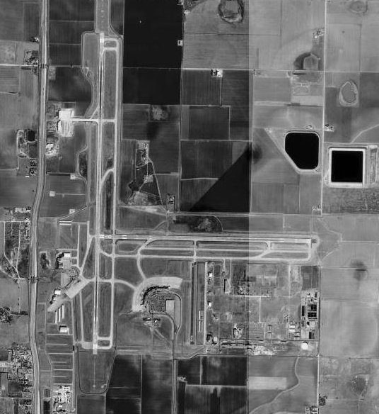
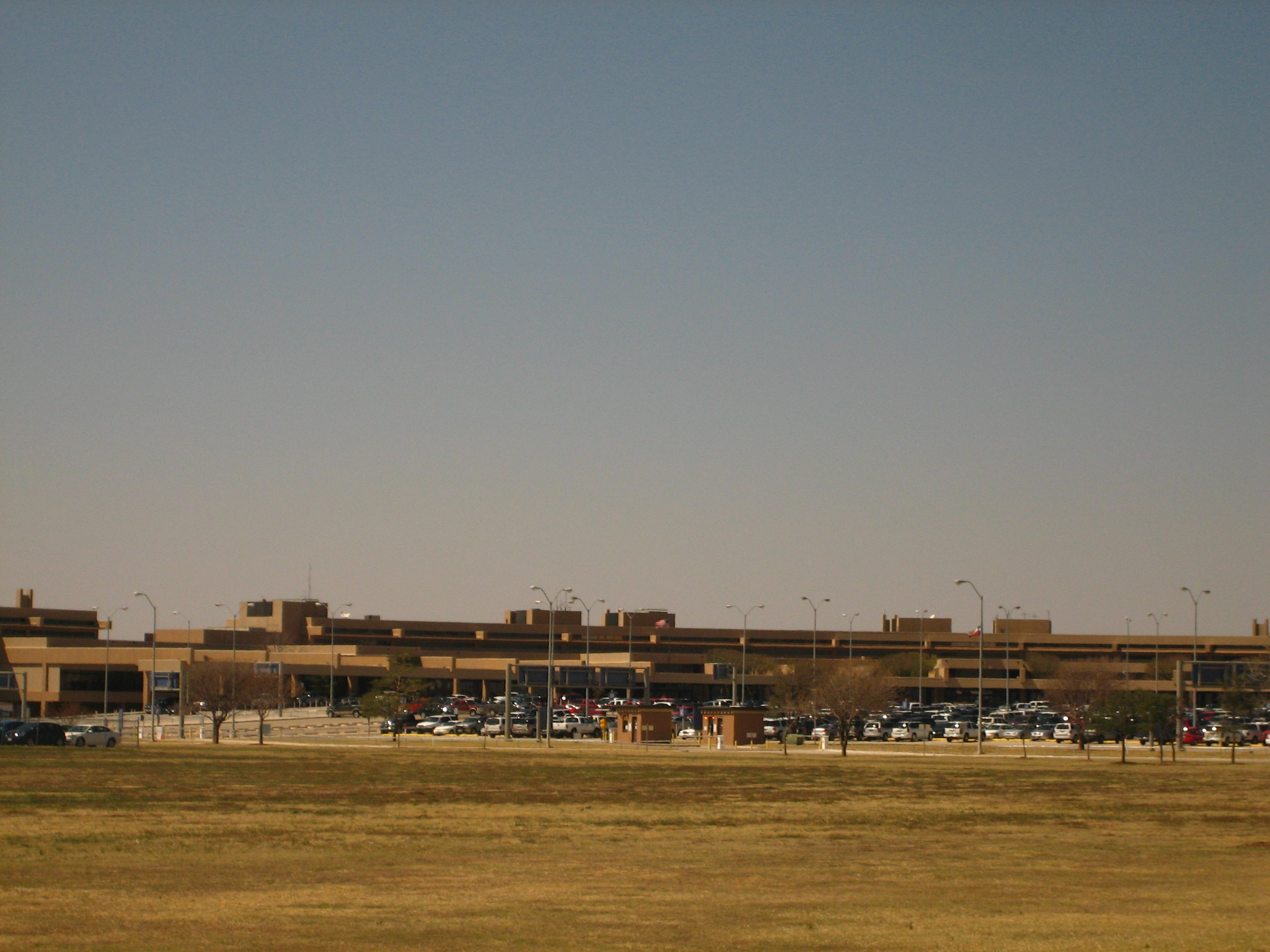
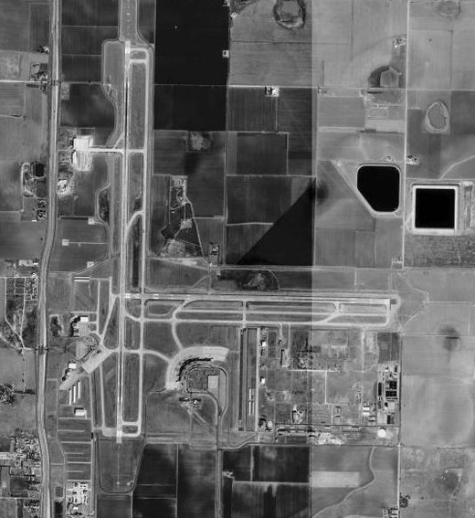
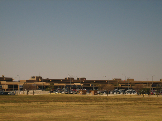
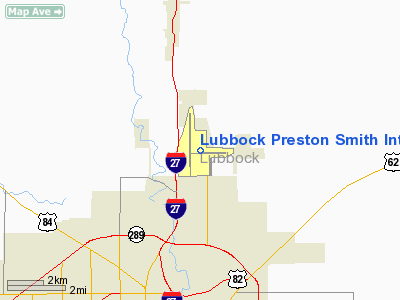
Lubbock Preston Smith Intl Airport |
| Lubbock Preston Smith International Airport |
 |
| IATA: LBB – ICAO: KLBB |
| Summary |
| Airport type |
Public |
| Operator |
City of Lubbock |
| Location |
Lubbock, Texas |
| Elevation AMSL |
3,282 ft / 1,000 m |
| Coordinates |
33°39′49″N 101°49′22″W / 33.66361°N 101.82278°W / 33.66361; -101.82278 |
| Runways |
| Direction |
Length |
Surface |
| ft |
m |
| 8/26 |
8,001 |
2,439 |
Concrete |
| 17R/35L |
11,500 |
3,502 |
Concrete |
| 17L/35R |
2,891 |
881 |
Asphalt |
Lubbock Preston Smith International Airport (IATA: LBB, ICAO: KLBB) is an airport located just north of Lubbock, Texas. Originally known as Lubbock International Airport, it was renamed in 2004 to honor and former Texas governor Preston E. Smith, an alumnus of Texas Tech University. The airport has three runways. Information
 | |
Lubbock Preston Smith International Airport |
The airport is the 8th busiest airport in Texas, with more than 90,000 more enplaned people than the 9th busiest. Lubbock International is first among the smaller Texas cities (behind only Dallas, Houston, San Antonio, Austin, and El Paso). It just finished completion on its major re-construction and re-configuration of its parking facilities. Wait times at this airport are extremely minimal usually taking about ten minutes from entering the airport, to ticket-counters, to gate. Lubbock Preston Smith international Airport is one of only 42 airports around the world with CNN Airport Network. Lubbock Preston Airport plays host as a major hub to Fedex's feeder planes that serve cities around Lubbock.
History
The airport was opened in November 1937 as South Plains Airport. In 1942, the United States Army Air Forces indicated a need for the airport as a training airfield. After its requisition by the Air Force, it was assigned to the World War II Army Air Forces Flying Training Command, Gulf Coast Training Center (later Central Flying Training Command). The airport was renmed South Plains Army Airfield and a rapid period of construction was begun to convert the civil airport into a military training airfield.
Construction involved improving runways and airplane hangars, with three concrete runways, several taxiways and a large parking apron and a control tower. Several large hangars were also constructed. Buildings were ultimately utilitarian and quickly assembled. Most base buildings, not meant for long-term use, were constructed of temporary or semi-permanent materials. Although some hangars had steel frames and the occasional brick or tile brick building could be seen, most support buildings sat on concrete foundations but were of frame construction clad in little more than plywood and tarpaper.
The base was activated on 11 September 1942 as the South Plains Flying School. The mission was ground and flying training of glider pilots. Glider training was performed by the 848th School Squadron (Special), with overall training being under the 64th Two-Engine Flying Training Group. Aircraft assigned were Douglas C-47 Skytrains and Waco CG-4A gliders. The CG-4A was the USAAF's primary glider, consisting of little more than a wooden and fabric shell, equipped with radio, wheels, and brakes. Glider pilots trained at South Plains flew these craft in combat during the Normandy Invasion, Operation Market-Garden, and also Operation Varsity, the airborne invasion of Germany.
By late 1944 Flying Training Command ended all glider instruction, and control of South Plains AAF was transferred to Air Service Command at Tinker Field, Oklahoma. Under Air Service Command, South Plains became a maintenance and supply depot for excess aircraft that could not be accommodated at Tinker. After the war ended, in 1946 and 1947, South Plains was used as a storage facility for excess aircraft prior to their reclamation.
The military use of South Plains ended on December 1, 1947 and the facility was returned to the local government for civil use.
Historically, Braniff International Airways had regularly scheduled service to Amarillo and Dallas. Continental Airlines had service to Dallas, Midland/Odessa, El Paso and Los Angeles. Trans-Texas Airways had service to Amarillo and Abilene. Texas International Airlines had service to Dallas. America West Airlines had service to Midland/Odessa, Phoenix, and Las Vegas. United Airlines had service to Denver. Some of these previously scheduled flights were from the old facility before Preston Smith International operations commenced. Delta Air Lines also used to offer service to its hub at Dallas.
Airlines and destinations
| Airlines |
Destinations |
| American Eagle |
Dallas/Fort Worth |
| Continental Express operated by ExpressJet Airlines |
Houston-Intercontinental |
| Delta Connection operated by Pinnacle Airlines |
Memphis |
| Southwest Airlines |
Albuquerque, Austin, Dallas-Love, Las Vegas |
Cargo carriers
- FedEx Express (Memphis, Tucson)
- Ameriflight (Dallas/ Ft.Worth)
- Empire Airlines (Midland, Ft.Worth Alliance)
- Baron Aviation Services (Abilene, Roswell)
Accidents and incidents
- On July 8, 1962, Vickers Viscount N243V of Continental Airlines was damaged beyond economic repair when the propellers struck the runway shortly after take-off. A wheels-up landing was made in a wheat field.
- On 27 January 2009, an Empire Airlines ATR-42 cargo plane under contract from FedEx Express crashed on landing at Lubbock Preston Smith International Airport at 04:37 CT. The plane, which had been traveling from Fort Worth Alliance Airport, landed short of the touchdown zone and skidded off the runway amid light freezing rain. There was a small fire on the plane and two crew members were taken to hospital with minor injuries.
The above content comes from Wikipedia and is published under free licenses – click here to read more.
Location & QuickFacts
| FAA Information Effective: | 2008-09-25 |
| Airport Identifier: | LBB |
| Airport Status: | Operational |
| Longitude/Latitude: | 101-49-22.0000W/33-39-49.1000N
-101.822778/33.663639 (Estimated) |
| Elevation: | 3282 ft / 1000.35 m (Surveyed) |
| Land: | 3000 acres |
| From nearest city: | 4 nautical miles N of Lubbock, TX |
| Location: | Lubbock County, TX |
| Magnetic Variation: | 09E (1985) |
Owner & Manager
| Ownership: | Publicly owned |
| Owner: | City Of Lubbock |
| Address: | Po Box 2000
Lubbock, TX 79457 |
| Phone number: | 806-775-3000 |
| Manager: | James Loomis |
| Address: | Rt 3 Box 389
Lubbock, TX 79401 |
| Phone number: | 806-775-3126 |
Airport Operations and Facilities
| Airport Use: | Open to public |
| Wind indicator: | Yes |
| Segmented Circle: | No |
| Control Tower: | Yes |
| Lighting Schedule: | DUSK-DAWN |
| Beacon Color: | Clear-Green (lighted land airport) |
| Landing fee charge: | No |
| Sectional chart: | Dallas-ft Worth |
| Region: | ASW - Southwest |
| Boundary ARTCC: | ZFW - Fort Worth |
| Tie-in FSS: | FTW - Fort Worth |
| FSS on Airport: | No |
| FSS Phone: | 817-541-3474 |
| FSS Toll Free: | 1-800-WX-BRIEF |
| NOTAMs Facility: | LBB (NOTAM-d service avaliable) |
| Certification type/date: | I C S 05/1973 |
| Federal Agreements: | NGPY |
Airport Communications
Airport Services
| Fuel available: | 100LLA A1+ |
| Airframe Repair: | MAJOR |
| Power Plant Repair: | MAJOR |
| Bottled Oxygen: | HIGH/LOW |
| Bulk Oxygen: | HIGH/LOW |
Runway Information
Runway 08/26
| Dimension: | 8001 x 150 ft / 2438.7 x 45.7 m |
| Surface: | CONC, Good Condition |
| Surface Treatment: | Saw-cut or plastic Grooved |
| Weight Limit: | Single wheel: 100000 lbs.
Dual wheel: 170000 lbs.
Dual tandem wheel: 350000 lbs. |
| Edge Lights: | High |
| |
Runway 08 |
Runway 26 |
| Longitude: | 101-49-44.9120W | 101-48-10.2709W |
| Latitude: | 33-39-43.9077N | 33-39-44.3732N |
| Elevation: | 3257.00 ft | 3255.00 ft |
| Alignment: | 90 | 127 |
| ILS Type: | | ILS
|
| Traffic Pattern: | Right | Left |
| Markings: | Precision instrument, Good Condition | Precision instrument, Good Condition |
| Crossing Height: | 52.00 ft | 45.00 ft |
| Displaced threshold: | 200.00 ft | 0.00 ft |
| VASI: | 4-box on left side | 4-box on left side |
| Visual Glide Angle: | 3.00° | 3.00° |
| RVR Equipment: | | touchdown |
| Approach lights: | | MALSR |
| Runway End Identifier: | Yes | |
| Decleard distances: | Take off run available 8001.00 ft
Take off distance available 8001.00 ft
Actual stop distance available 8001.00 ft
Landing distance available 7801.00 ft
| Take off run available 8001.00 ft
Take off distance available 8001.00 ft
Actual stop distance available 8001.00 ft
Landing distance available 8001.00 ft
|
|
Runway 17L/35R
| Dimension: | 2891 x 75 ft / 881.2 x 22.9 m |
| Surface: | ASPH, Good Condition |
| Weight Limit: | Single wheel: 12500 lbs. |
| |
Runway 17L |
Runway 35R |
| Longitude: | 101-49-01.7572W | 101-49-01.5463W |
| Latitude: | 33-39-35.3488N | 33-39-06.7548N |
| Elevation: | 3254.00 ft | 3262.00 ft |
| Alignment: | 127 | 127 |
| Traffic Pattern: | Left | Right |
| Markings: | Basic, Good Condition | Basic, Good Condition |
| Obstruction: | , 50:1 slope to clear | 18 ft road, 573.0 ft from runway, 162 ft right of centerline, 20:1 slope to clear |
| Decleard distances: | Take off run available 2891.00 ft
Take off distance available 2891.00 ft
Actual stop distance available 2891.00 ft
Landing distance available 2891.00 ft
| Take off run available 2891.00 ft
Take off distance available 2891.00 ft
Actual stop distance available 2891.00 ft
Landing distance available 2891.00 ft
|
|
Runway 17R/35L
| Dimension: | 11500 x 150 ft / 3505.2 x 45.7 m |
| Surface: | CONC, Good Condition |
| Surface Treatment: | Saw-cut or plastic Grooved |
| Weight Limit: | Single wheel: 100000 lbs.
Dual wheel: 170000 lbs.
Dual tandem wheel: 350000 lbs. |
| Edge Lights: | High |
| |
Runway 17R |
Runway 35L |
| Longitude: | 101-49-44.5302W | 101-49-43.7407W |
| Latitude: | 33-40-56.4957N | 33-39-02.7455N |
| Elevation: | 3282.00 ft | 3242.00 ft |
| Alignment: | 127 | 127 |
| ILS Type: | ILS/DME
| |
| Traffic Pattern: | Right | Left |
| Markings: | Precision instrument, Good Condition | Precision instrument, Good Condition |
| Crossing Height: | 0.00 ft | 54.00 ft |
| VASI: | | 4-box on left side |
| Visual Glide Angle: | 0.00° | 3.00° |
| RVR Equipment: | touchdown | |
| Approach lights: | MALSR | ODALS |
| Decleard distances: | Take off run available 11500.00 ft
Take off distance available 11500.00 ft
Actual stop distance available 11500.00 ft
Landing distance available 11500.00 ft
| Take off run available 11500.00 ft
Take off distance available 11500.00 ft
Actual stop distance available 11500.00 ft
Landing distance available 11500.00 ft
|
|
Radio Navigation Aids
| ID |
Type |
Name |
Ch |
Freq |
Var |
Dist |
| LLN | NDB | Levelland | | 266.00 | 09E | 28.4 nm |
| CZX | NDB | Crosbyton | | 332.00 | 09E | 29.3 nm |
| LIU | NDB | Littlefield | | 212.00 | 10E | 32.1 nm |
| BFE | NDB | Brownfield | | 311.00 | 09E | 34.5 nm |
| PVW | VOR/DME | Plainview | 076X | 112.90 | 11E | 25.5 nm |
| LBB | VORTAC | Lubbock | 029X | 109.20 | 11E | 5.2 nm |
Remarks
- RY 17L/35R RESTRICTED TO GENERAL AVIATION ACFT 12,500 LBS OR LESS.
- TWYS A; B; D; E & G RESTRICTED TO ACFT WEIGHING LESS THAN 50,000 LBS.
- PASSENGER TERMINAL RAMP ACCESS RESTRICTED TO AIR CARRIERS & OTHERS WITH PRIOR PERMISSION CALL 806-775-2044.
- RY 17L/35R; TWYS A; B; D; E & G NOT AVBL FOR ACR ACFT WITH OVER 9 PSGR SEATS.
- NUMEROUS BIRDS ON & INVOF ARPT.
- EAST RAMP DELINEATED TAXILANE & APRON AREA RESTRICTED TO 120,000 LBS DUAL TANDEM ACFT, 89,000 LBS DUAL SINGLE WHEEL ACFT & 60,000 LBS SINGLE WHEEL ACFT. ALL OTHER EAST RAMP PAVEMENTS RESTRICTED TO ACFT LESS THAN 12,500 LBS SINGLE WHEEL ACFT.
Images and information placed above are from
http://www.airport-data.com/airport/LBB/
We thank them for the data!
| General Info
|
| Country |
United States
|
| State |
TEXAS
|
| FAA ID |
LBB
|
| Latitude |
33-39-49.100N
|
| Longitude |
101-49-22.000W
|
| Elevation |
3282 feet
|
| Near City |
LUBBOCK
|
We don't guarantee the information is fresh and accurate. The data may
be wrong or outdated.
For more up-to-date information please refer to other sources.
|
|