 |
|
Location & QuickFacts
| FAA Information Effective: | 2008-09-25 |
| Airport Identifier: | 7TE3 |
| Airport Status: | Operational |
| Longitude/Latitude: | 098-28-01.1350W/31-14-00.6010N
-98.466982/31.233500 (Estimated) |
| Elevation: | 1400 ft / 426.72 m (Estimated) |
| Land: | 21 acres |
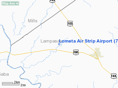
| From nearest city: | 3 nautical miles W of Lometa, TX |
| Location: | Lampasas County, TX |
| Magnetic Variation: | 07E (1985) |
Owner & Manager
| Ownership: | Privately owned |
| Owner: | Weldon Kirby |
| Address: | Po Box 178
Lometa, TX 76853 |
| Phone number: | 512-752-3584 |
| Manager: | Weldon Kirby |
| Address: | Po Box 178
Lometa, TX 76853 |
| Phone number: | 512-752-3584 |
Airport Operations and Facilities
| Airport Use: | Private |
| Wind indicator: | Yes |
| Segmented Circle: | No |
| Control Tower: | No |
| Landing fee charge: | No |
| Sectional chart: | San Antonio |
| Region: | ASW - Southwest |
| Boundary ARTCC: | ZHU - Houston |
| Tie-in FSS: | SJT - San Angelo |
| FSS on Airport: | No |
| FSS Toll Free: | 1-800-WX-BRIEF |
Airport Services
| Airframe Repair: | NONE |
| Power Plant Repair: | NONE |
Runway Information
Runway 17/35
| Dimension: | 2290 x 110 ft / 698.0 x 33.5 m |
| Surface: | TURF, Fair Condition |
| |
Runway 17 |
Runway 35 |
| Traffic Pattern: | Left | Left |
| Obstruction: | 20 ft tree, 72 ft right of centerline
+4' FENCE 89' RIGHT OF CNTRLN. | 4 ft fence, 0.0 ft from runway, 89 ft left of centerline
+4' FENCE 89' LEFT OF CNTRLN. |
|
Radio Navigation Aids
| ID |
Type |
Name |
Ch |
Freq |
Var |
Dist |
| MNZ | NDB | Hamilton | | 251.00 | 07E | 28.4 nm |
| GR | NDB | Starn | | 323.00 | 07E | 30.5 nm |
| BMQ | NDB | Burnet | | 341.00 | 07E | 31.9 nm |
| HLR | NDB | Hood | | 347.00 | 07E | 39.4 nm |
| IL | NDB | Iresh | | 278.00 | 07E | 41.0 nm |
| MFS | NDB | Horseshoe Bay Resort | | 403.00 | 07E | 43.1 nm |
| BBD | NDB | Brady | | 380.00 | 07E | 44.1 nm |
| GRK | VOR/DME | Gray | 055X | 111.80 | 07E | 35.7 nm |
| BWD | VOR/DME | Brownwood | 023X | 108.60 | 08E | 46.9 nm |
| LZZ | VORTAC | Lampasas | 072X | 112.50 | 08E | 17.0 nm |
| LLO | VORTAC | Llano | 019X | 108.20 | 08E | 31.0 nm |
Remarks
- CTN: CATTLE & DEER ON & INVOF ARPT.
- PRE DATES THE ACT.
Images and information placed above are from
http://www.airport-data.com/airport/7TE3/
We thank them for the data!
| General Info
|
| Country |
United States
|
| State |
TEXAS
|
| FAA ID |
7TE3
|
| Latitude |
31-14-00.601N
|
| Longitude |
098-28-01.135W
|
| Elevation |
1400 feet
|
| Near City |
LOMETA
|
We don't guarantee the information is fresh and accurate. The data may
be wrong or outdated.
For more up-to-date information please refer to other sources.
|
|


