 |
|
Coordinates: 30°47′01″N 098°39′43″W / 30.78361°N 98.66194°W / 30.78361; -98.66194
| Llano Municipal Airport |
| IATA: none – ICAO: KAQO – FAA LID: AQO |
| Summary |
| Airport type |
Public |
| Owner |
City of Llano |
| Serves |
Llano, Texas |
| Elevation AMSL |
1,102 ft / 336 m |
| Website |
www.llanotx.com/... |
| Runways |
| Direction |
Length |
Surface |
| ft |
m |
| 17/35 |
4,202 |
1,281 |
Asphalt |
| 13/31 |
3,240 |
988 |
Turf |
| Statistics (2006) |
| Aircraft operations |
11,100 |
| Based aircraft |
41 |
| Source: Federal Aviation Administration |
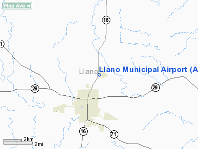
Llano Municipal Airport (ICAO: KAQO, FAA LID: AQO) is a public airport located two miles (3 km) northeast of the central business district of Llano, a city in Llano County, Texas, United States. It is owned by the City of Llano.
Although most U.S. airports use the same three-letter location identifier for the FAA and IATA, Llano Municipal is assigned AQO by the FAA but has no designation from the IATA. The airport's former FAA indentifier was 6R9.
Facilities and aircraft
Llano Municipal Airport covers an area of 95 acres (38 ha) which contains two runways: 17/35 with an asphalt pavement measuring 4,202 x 75 ft (1,281 x 23 m) and 13/31 with a turf surface measuring 3,240 x 150 ft (988 x 46 m).
For the 12-month period ending March 10, 2006, the airport had 11,100 aircraft operations, an average of 30 per day, all of which were general aviation. There are 41 aircraft based at this airport: 90% single-engine, 5% glider and 5% ultralight.
The above content comes from Wikipedia and is published under free licenses – click here to read more.
Location & QuickFacts
| FAA Information Effective: | 2008-09-25 |
| Airport Identifier: | AQO |
| Airport Status: | Operational |
| Longitude/Latitude: | 098-39-43.3000W/30-47-01.4000N
-98.662028/30.783722 (Estimated) |
| Elevation: | 1102 ft / 335.89 m (Surveyed) |
| Land: | 95 acres |
| From nearest city: | 2 nautical miles NE of Llano, TX |
| Location: | Llano County, TX |
| Magnetic Variation: | 08E (1980) |
Owner & Manager
| Ownership: | Publicly owned |
| Owner: | City Of Llano |
| Address: | 301 W Main
Llano, TX 78643 |
| Phone number: | 325-247-4158 |
| Manager: | Larry Cook |
| Address: | 301 W. Main
Llano, TX 78643 |
| Phone number: | 325247-5635 |
Airport Operations and Facilities
| Airport Use: | Open to public |
| Wind indicator: | Yes |
| Segmented Circle: | Yes |
| Control Tower: | No |
| Lighting Schedule: | DUSK-DAWN
MIRL RY 17/35 PRESET LOW INTST; TO INCR INTST ACTVT - CTAF. |
| Beacon Color: | Clear-Green (lighted land airport) |
| Landing fee charge: | No |
| Sectional chart: | San Antonio |
| Region: | ASW - Southwest |
| Boundary ARTCC: | ZHU - Houston |
| Tie-in FSS: | SJT - San Angelo |
| FSS on Airport: | No |
| FSS Toll Free: | 1-800-WX-BRIEF |
| NOTAMs Facility: | AQO (NOTAM-d service avaliable) |
| Federal Agreements: | N |
Airport Communications
| CTAF: | 122.800 |
| Unicom: | 122.800 |
Airport Services
| Fuel available: | 100LLA
SELF-SERVICE FUEL AVBL 24 HRS WITH CREDIT CARD. |
| Bottled Oxygen: | NONE |
| Bulk Oxygen: | NONE |
Runway Information
Runway 13/31
| Dimension: | 3240 x 150 ft / 987.6 x 45.7 m |
| Surface: | TURF, Good Condition |
| |
Runway 13 |
Runway 31 |
| Longitude: | 098-39-41.1350W | 098-39-16.0570W |
| Latitude: | 30-47-19.6390N | 30-46-55.9840N |
| Elevation: | 1110.00 ft | 1090.00 ft |
| Alignment: | 127 | 127 |
| Traffic Pattern: | Left | Left |
| Obstruction: | , 50:1 slope to clear | 12 ft trees, 270.0 ft from runway, 23:1 slope to clear |
|
Runway 17/35
| Dimension: | 4202 x 75 ft / 1280.8 x 22.9 m |
| Surface: | ASPH, Good Condition |
| Weight Limit: | Single wheel: 20000 lbs. |
| Edge Lights: | Medium |
| |
Runway 17 |
Runway 35 |
| Longitude: | 098-39-43.6367W | 098-39-42.9823W |
| Latitude: | 30-47-22.2237N | 30-46-40.6425N |
| Elevation: | 1102.00 ft | 1102.00 ft |
| Alignment: | 127 | 127 |
| Traffic Pattern: | Left | Left |
| Markings: | Non-precision instrument, Good Condition | Non-precision instrument, Good Condition |
| Crossing Height: | 60.00 ft | 0.00 ft |
| VASI: | 2-light PAPI on left side | |
| Visual Glide Angle: | 3.00° | 0.00° |
| Obstruction: | 19 ft trees, 435.0 ft from runway, 277 ft left of centerline, 12:1 slope to clear | , 50:1 slope to clear |
|
Radio Navigation Aids
| ID |
Type |
Name |
Ch |
Freq |
Var |
Dist |
| BMQ | NDB | Burnet | | 341.00 | 07E | 22.1 nm |
| MFS | NDB | Horseshoe Bay Resort | | 403.00 | 07E | 22.2 nm |
| BBD | NDB | Brady | | 380.00 | 07E | 41.5 nm |
| GR | NDB | Starn | | 323.00 | 07E | 46.5 nm |
| GRK | VOR/DME | Gray | 055X | 111.80 | 07E | 46.2 nm |
| LLO | VORTAC | Llano | 019X | 108.20 | 08E | 6.5 nm |
| STV | VORTAC | Stonewall | 085X | 113.80 | 08E | 34.8 nm |
| LZZ | VORTAC | Lampasas | 072X | 112.50 | 08E | 36.1 nm |
Remarks
- DEER ON & INVOF RY.
- PRE-DATES THE ACT.
Images and information placed above are from
http://www.airport-data.com/airport/AQO/
We thank them for the data!
| General Info
|
| Country |
United States
|
| State |
TEXAS
|
| FAA ID |
AQO
|
| Latitude |
30.783722
30° 47' 01.40" N
|
| Longitude |
-98.662028
098° 39' 43.30" W
|
| Elevation |
1102 feet
336 meters
|
| Type |
Civil
|
| Magnetic Variation |
005° E (01/06)
|
| Beacon |
Yes
|
| Operating Agency |
MUNICIPAL
|
| Daylight Saving Time |
Second Sunday in March at 0200 to first Sunday in November at 0200 local time (Exception Arizona and that portion of Indiana in the Eastern Time Zone)
|
We don't guarantee the information is fresh and accurate. The data may
be wrong or outdated.
For more up-to-date information please refer to other sources.
|
|


